
Casa de Piedra, also known as Residencia Amparo Roldán, in Aguadilla, Puerto Rico, is a Spanish Colonial-style home that was erected in 1875. It is the only surviving residence of its era in Aguadilla; most similar ones were damaged in the 1918 San Fermín earthquake and eventually demolished.

The Hacienda Casa del Francés, near Esperanza on the island of Vieques, Puerto Rico, also known as Sportsmen's House, was a plantation house built in 1910. It was listed on the National Register of Historic Places in 1977, and on the Puerto Rico Register of Historic Sites and Zones in 2000.

The Casa Roig Museum is a historic house museum and gallery in Humacao, Puerto Rico. It was designed as a residence for the wealthy sugar planter Antonio Roig by the prominent Czech architect and Puerto Rico resident Antonin Nechodoma (1877–1928) and built in 1920.

Edificio Oliver in Arecibo, Puerto Rico was built in 1914. The building houses government offices for the municipality of Arecibo.

The San Germán Historic District is a 36-acre (15 ha) historic district located in the western section of the town of San Germán, Puerto Rico. The district was added to both the National Register of Historic Places and the Puerto Rico Register of Historic Sites and Zones in 1994. The district contains more than 100 significant buildings, including the Church San Germán de Auxerre and the Convento de Porta Coeli.

Casa de España is the headquarters of a private social organization whose members are those of Spanish descent in San Juan, Puerto Rico on Avenida de La Constitución in Old San Juan.

Hacienda Santa Rita is located in the municipality of Guánica, Puerto Rico. It is also known as Casa Madre y Noviciado de las Hermanas Dominicas de Fatima and was built in 1800 by Don Mariano Quiñonez.

Casa Paoli is a historic house and biographical museum in barrio Cuarto, Ponce, Puerto Rico, in the Ponce Historic Zone. The house is significant as the birthplace of Antonio Paoli (1871–1946), a tenor who was the "first Puerto Rican to reach international recognition in the performing arts" and "one of the most outstanding opera singers of all times". The house was the childhood home of the artist and he was introduced to art and opera at this house during his formative years. In 1987, the house was turned into a museum to honor the career of Antonio Paoli. The building was listed on the U.S. National Register of Historic Places in 2009.

The Cementerio Municipal de Mayagüez, also known as Cementerio Viejo, was constructed in 1876 in Mayaguez, Puerto Rico. It was designed by the municipal architect Félix Vidal d’Ors following the master plan for the city from 1804. The outskirts of the cemetery are defined by brick walls and niches, the area is divided by two streets that intersect. Following an 1872 law the cemetery provided separated areas intended for non-Catholics and for the poor, located in the east.

The José Celso Barbosa House Museum is a historic house museum in Bayamón municipality, Puerto Rico.

Vega Baja barrio-pueblo is a barrio and downtown area that serves as the administrative center (seat) of Vega Baja, a municipality of Puerto Rico. Its population in 2010 was 816.

Caguas Pueblo is a barrio and downtown area that serves the administrative center (seat) of the city and municipality of Caguas, a municipality of Puerto Rico. It is bordered by the Cagüitas River to the north and located two miles southwest of the Río Grande de Loíza. Its population in 2020 was 19,020.

The Edificio Alcaldia is a historic building in Carolina, Puerto Rico. The building was designed by Puerto Rican architect Rafael Carmoega, then an architect of the Department of the Interior, with assistance of Francisco Garden. The Department of the Interior also built the building. In addition to serving as the City Hall, the facilities included government offices, the Municipal Jail, and a Medical Office.

Casa Alcaldía de Arecibo, formerly known as the Casa Consistorial, is the historic city hall and municipal administrative headquarters of the Puerto Rican municipality of Arecibo located in the Plaza Mayor in downtown Arecibo. Constructed by the Spanish between 1850 and 1866, more than 155 years ago, this government building exhibits the standard Neoclassic style that distinguishes the Spanish architecture of the time. The building was added to the National Register of Historic Places in 1986, and to the Puerto Rico Register of Historic Sites and Zones in 2000.

Casa Córdova, also known as Casa de las Conchas, is a historic building located at 14 Gonzalo Marín Street in the historic center of the Puerto Rican municipality of Arecibo. The historic residence, now a commercial building, was added to the United States National Register of Historic Places on November 17, 1986, and to the Puerto Rico Register of Historic Sites and Zones in 2000.
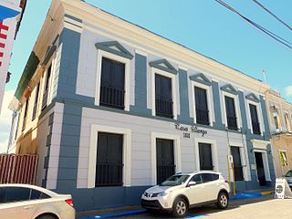
Casa Ulanga, also known as the former Superior Court of Arecibo, is a historic building located at 7 Gonzalo Marín Street in the historic center of the Puerto Rican municipality of Arecibo. Due to its historic and architectural importance the building was added to the United States National Register of Historic Places on July 26, 1982, and to the Puerto Rico Register of Historic Sites and Zones in 2000.
The Doña Antonia Ramírez Residence, also known as the Hernández Residence, is a historic Italianate-style residential building located in the Maguayo barrio of Dorado, Puerto Rico. The house was added to the United States National Register of Historic Places in 1988, and to the Puerto Rico Register of Historic Sites and Zones in 2000.

The Pereyó House, formally referred to as the Palmira López de Pereyó Residence, is a historic Prairie School-style house from 1930 designed by Francisco Valinés Cofresí located in Humacao, Puerto Rico. It was added to the United States National Register of Historic Places in 1995, and to the Puerto Rico Register of Historic Sites and Zones on May 16, 2001.

The Church Santa María del Rosario of Vega Baja is a historic Catholic parish church from 1860 located in the main public square (plaza) of Vega Baja Pueblo, the historic and cultural downtown of the municipality of Vega Baja, Puerto Rico. The parish, which is part of the Roman Catholic Diocese of Arecibo, was added to the United States National Register of Historic Places in 1984 as part of the Historic Churches of Puerto Rico thematic multiple property submission. It was later added to the Puerto Rico Register of Historic Sites and Zones in 2000.

The Vieques City Hall, also known as the Vieques Municipal House and formerly known as Casa del Rey, is a historic civic building located in the main town square of Isabel Segunda, the administrative center and main settlement of the island-municipality of Vieques, Puerto Rico. It was added to the National Register of Historic Places in 1994, and to the Puerto Rico Register of Historic Sites and Zones in 2001.

