Castell Caer Seion

Last updated

Castell Caer Seion
Panorama of Castell Caer Seion.jpg
Castell Caer Seion at the summit of Conwy Mountain
Conwy UK location map.svg
Archaeological site icon (red).svg
Castell Caer Seion shown within Conwy
Alternative nameCastell Caer Lleion, Castell Caer Leion, Conwy Mountain Hillfort, Sinnodune
Coordinates 53°16′57″N3°51′44″W / 53.282512°N 3.862296°W / 53.282512; -3.862296 Coordinates: 53°16′57″N3°51′44″W / 53.282512°N 3.862296°W / 53.282512; -3.862296
OS grid reference SH 75938 77782
Altitude244 m (801 ft)
Type Hillfort
Width95 m (310 ft)
Volume30351 m² (326699 f²)
Diameter326 m (1069 ft)
History
MaterialStone, earth
Founded6th–4th centuries BC (first phase), 3rd century BC (second phase)
Abandoned2nd century BC
Periods Iron Age
Site notes
Excavation dates1906, 1909, 1951, 1952, 2008
ArchaeologistsH. Picton, W. Bezant Lowe, W .E. Griffiths & A. H. A. Hogg, George Smith
ConditionRuined, but good.
Management Cadw
Public accessYes
DesignationScheduled Ancient Monument

Castell Caer Seion is an Iron Age hillfort situated at the top of Conwy Mountain, in Conwy County, North Wales. It is unusual for the fact that the main fort contains a smaller, more heavily defended fort, complete with its own distinct defences and entrance, with no obvious means of access between the two. The construction date of the original fort is still unknown, but recent excavations have revealed evidence of occupation as early as the 6th century BC, whilst the smaller fort can be dated with reasonable certainty to around the 4th century BC. Whilst the forts were constructed in different periods, archaeologists have uncovered evidence of concurrent occupation, seemingly up until around the 2nd century BC. The larger fort contained around 50 roundhouses during its lifetime, whereas examinations of the smaller fort have turned up no more than six. [1] The site was traditionally associated with Maelgwyn Gwynedd (c. 480 – c. 547 AD), [2] but there is no evidence pointing to a 6th-century occupation. [3] The fort and wider area beyond its boundaries have been said to retain significant archaeological potential, and are protected by law as a scheduled ancient monument. [2]

Contents

Description

Annotated plan of Caer Seion. Annotated plan of Caer Seion.png
Annotated plan of Caer Seion.

The fort is on the summit of a ridge of rhyolite at an altitude of approximately 800 feet (244 m) and is enclosed by a single rampart, with more complex works protecting a smaller fortified area at the western end. The northern side of the ridge is steep enough to offer a natural defence meaning that no outer wall was needed for the first phase of construction. [3] [4] The smaller fort was built inside the western margins of the larger fort sometime around the 4th century BC; it was completely enclosed, and defended by thick stone walls on all sides, with defensive ditches running along the eastern and north-eastern boundary and a defensive outwork to the southeast. The site has a commanding position overlooking Conwy Bay, and is situated close to a major trackway that follows the coastal ridge. The total area of the fort is 7.5 acres (3.0 ha), it is roughly 326 metres (1,070 ft) long, and at its widest measures around 95 metres (312 ft) from the southern ramparts to the cliffs on the northern boundary. [5]

Confusion surrounding name

Writing in Archaeologia Cambrensis, W.E. Griffiths and A. H. A. Hogg identify 'Caer Seion' as the older and more genuine name of the hillfort, for which they cite evidence dating as far back as the 9th century. The alternative name 'Castell Caer Lleion' seems to date to the late 17th century and probably came about due to a mistranslation. Indeed, 'Castell Caer' is somewhat of a tautology, translating into English as "Castle Fort". [6] Because there is no standardised name for the site, it is referred to variously as 'Caer Seion', 'Castell Caer Seion', 'Castell Caer Lleion', 'Castell Caer Leion' and 'Conwy Mountain hillfort'. [7] < [2] [8] An antiquated name, no longer in popular use but recorded by John Leyland in his 1530s Itinerary in Wales, is 'Sinnodune'. [9]

Archaeological excavations

There have been three principal excavations at the site: first in 1906 and 1909, then in 1951 and 1952, and finally in 2008. The dearth of dateable finds meant that, until the early part of the 21st century, the dating of the site was largely inferential. Each excavation has revealed a little more about the site, with modern techniques enabling archaeologists to date the earliest known occupation of the fort to within 200 years. [10]

First excavation: 1906, 1909

The first recorded excavations – carried out by Harold Picton and W. Bezant Lowe – were begun in 1906, before a delay caused them to briefly abandon the project and resume it in 1909. Their excavations revealed little, but they are the first to record finding sling stones at the site, and they also turned up a rubbing stone. Bezant Lowe noted the possible existence of a semi-circular defence facing the entrance to the smaller fort. [11] In one of the huts at the south-western end of the small fort they uncovered a stone floor, haphazard for the most part, but carefully laid and fitted together at one side of the hut. Picton notes that there was no evidence of the floor being used as a hearth, but does not speculate further as to the nature of the feature. [12]

Second excavation: 1951, 1952

Plan of later fort at western margin of Caer Seion. Plan of later fort at Caer Seion.png
Plan of later fort at western margin of Caer Seion.

By far the most extensive of the excavations were those conducted on behalf of the Royal Commission on the Ancient and Historical Monuments of Wales. Most of what we now know about the site stems from these digs, carried out by W.E. Griffiths and A.H.A. Hogg. They concluded that the site showed two periods of fortification, both within the latter part of the pre-Roman Iron Age. Whilst we now know that the fort was occupied as early as the Early to Middle Iron Age, the archaeologists did note at the time that their evidence for dating was slight; and for structural development was 'largely inferential'. They were the first to provide evidence that the two forts were designed to be used concurrently, based on the layout of the walls at the juncture of the two enclosures, and also speculate that the two separate enclosures were accessible to each other via some form of moveable ladder. No direct evidence exists to support this, but Griffiths and Hogg thought it likely because of the existence of a level causeway leading through the eastern defensive ditch to the northern corner of the small enclosure, where there were no entrances. (See F1 on the annotated plan; this feature is also clearly visible on the image in the infobox.)

Third excavation: 2008

The third excavation was small in scale, but important for being able to offer definitive dating evidence pertaining to the occupation of the two forts. It was carried out by George Smith of the Gwynedd Archaeological Trust, on behalf of Cadw, with environmental reports by Astrid E. Caseldine and Catherine Griffiths from the University of Wales. They were inspired to carry out this undertaking because of a 1991 survey (and subsequent report) by the Snowdonia National Park Authority, which remarked that the 1956 excavation had identified charcoal-rich layers that could be targeted for future research. The excavation and radiocarbon analysis of this charcoal allowed the team to place the earliest known occupation of the original fort at somewhere between the 6th and 4th centuries BC, and the construction of smaller fort around the 4th century BC. These investigations were not able to date the construction of the original fort, but did put the known occupation of the site back by a number of centuries, whilst also suggesting it was abandoned sometime before the 2nd century BC. [13] This would render a popular theory, that the fort was torn down as a result of the Roman invasion of Wales in 48 AD, unlikely. Analysis of pollen, grain and wood also allowed reasonable speculation to be made as to the likely diet and occupation of the fort's inhabitants, and also to the make-up of the wider landscape. (See "Environment" for further details.)

Huts

Only a small number of the more than 50 roundhouses known to have existed on site have ever been archaeologically excavated. The style of these huts seems largely contiguous throughout the two periods of the fort construction, with a general similarity in size and material found within. This contrasts with other sites which had occupation (or reoccupation) throughout the Roman period and beyond, where a distinct mix of architectural styles and hut shapes can often be observed. The roofing arrangements do, however, show some development on the site, with the dearth of post holes in the huts dated to the first period (Huts 1 and 3) suggesting some kind of wigwam roofing, whereas the hut that was examined from the later period (Hut 4) shows evidence of two systems of roof timbering involving internal posts. Many of the huts lay along a terrace behind the main southern rampart, where it has been speculated that the inhabitants would have been protected from the wind. [14]

Entrances

Three definite entrances were identified at the site, with another possible one speculated, but not confirmed. The only one to be examined fully was the main entrance to the earlier fort, whilst the other two were cleared of recent additions and surveyed in less detail.

Main entrance

The main entrance, located in the southern rampart slightly to the east of Hut 1, was 17 feet long and 8.6 inches at its narrowest point (see 'first fort entrance' on the annotated plan). The entrance appears to have been paved at one time, but the stones have now eroded and only slight traces remain. The thickened rampart of the outside entrance was supported by a plinth of large, flat blocks, set into a foundation trench, which extended 17 feet to the East; and sat flush with the surface of the subsoil, suggesting it would have been invisible when in contemporary use. This plinth was necessary to support the heavier parts of the rampart on the slope of the ground to the south. It is likely that four large, square post holes found at the East and West sides of the entrance passage, belonged to a wooden bridge over the gateway; and would have supported the (likely timber) [15] gate itself, probably on a pair of outer posts. The gate opening was 6 feet wide and could therefore have been secured by a single door.

Entrance to the smaller fort

Little is known about the entrance to the smaller fort as it has not been fully excavated, but the existence of large, square post holes similar to those found in the main entrance suggest that they probably served the same function as those found in the entrance to the main fort. The only notable difference was their location, with the post holes being situated not inside the passage itself, but around the corner of the passage, against the inner rampart.

Outwork entrance

The third entrance was in the defensive outwork structure located at the south-east of the site, (see 'blocked entrance to outwork' on the annotated plan). Minimal investigation was made of this feature, but enough to establish that it formed a passage about 19 feet wide and 23 feet long, set between the overlapping ends of the ramparts and faced with orthostats (a large stone with a more or less slab-like shape), some of which have been described as 'almost megalithic in character'. The North side had collapsed, blocking the entrance, but the archaeologists speculated that it must have been an impressive structure in its original form, and possibly designed with this effect in mind. [16] [4]

Defences

The main defences of both forts were stone-built walls of varying construction, sometimes accompanied on their outer side with a ditch. The larger fort remained almost unchanged during its lifetime and was protected by a single wall which enclosed the site on the three accessible sides, following the best natural line for defence. The smaller fort had two distinct periods of construction and was more strongly fortified than the main enclosure; its original incarnation being larger and more elaborately fortified, than its latter. Whilst most structural details of the site were simple, the defences of the small fort were particularly unusual in the context of other Iron Age hillforts, as they were designed to be defended against the inside of the main enclosure, as well as from outside attack.

Primary rampart

The primary rampart which enclosed the site on three sides (East, South and West), was said to follow a 'sinuous' course along the hill top, 'selecting the line most suitable for defence'. The outer southward face of this rampart was described as being much ruined, about 10 feet thick, built of fairly large stones, and potentially containing a number of slabs laid on edge. The inner face was built partly of laid masonry and partly of slabs laid on edge; the slabs were differing sizes but some are described as 'very large'. Around the entrance to the larger fort the rampart is noted as having double-facing, and further along to the east the outer face of the rampart is described as being well-preserved, with a pronounced batter (meaning it was deliberately constructed with a receding slope for stability). The steep cliffs to the North and north-east meant that no extra defences were needed on that side of the fort, but where the incline is shallower to the north-west, the remains of a rampart could be traced. It was described as much ruined and overgrown with turf, and the investigators could not make out its construction, although they did note an additional defensive ditch along its outside face (marked on the annotated map as D1). This ditch extended the length of the rampart and continued to the south-west, around a rocky outcrop at the extreme West of the site (see D2).

Small fortress

The south wall of the small enclosure was measured as being wider than that of the original rampart, being estimated at 12–16 feet thick; and built of laid masonry. Outside the south-west wall of the small fort, an additional defensive wall was examined and found to end on a rock outcrop at the westernmost point of the site (see R1 on map). The defensive ditch which followed the north-west rampart of the main fort, carried on around this wall, and where it rounded the western outcrop, there was clear evidence that a smaller, additional ditch had been cut (see E1). The larger of the ditches continued parallel to the southern wall of the smaller fort, ending just in front of the defensive outwork (see D3). Inside the large fort, and running parallel to the eastern wall of the small fort was an additional bank-and-ditch defence combination, which was interrupted by low causeways (see F1).

Outwork

The outwork was notable for the fact that it was constructed in a different fashion to the other walls on the site, being faced by large blocks laid flat – or as was the case near the entrance – with slabs on edge; and filled with small stones and earth.

Huts associated with defence

Two huts were also associated with the defences; hut 1 because of its location just inside the entrance to the larger fort, and also the hut adjoining hut 3 on its east, for the same reason. Bolstering this theory is the fact that in hut 1 the investigators found 612 sling stones, half of which lay stacked in a neat pile against the inner face of the south-east wall, suggesting their likely use as a defensive arsenal. Whilst the hut immediately to the East of hut 3 was not actually examined by the archaeologists; the discovery of a number of sling stones by Picton and Bezant Lowe at this site in 1909, somewhat corroborates this speculation. [16] [4]

Material finds

Various finds. Finds from Caer Seion.png
Various finds.

The site has yielded many small material finds which helped early archaeologists date the fort to the Iron Age period, in the absence of any datable pottery. Among the more notable finds were 1,141 sling stones, in the shape of smooth, oval beach pebbles, 1–2 inches long (about half of which were found together in a neat pile against the inner face of the hut wall) – a possible pair of iron tweezers, and a probable lignite spindlewhorl; which are found rarely in Britain. A small fragment of corroded iron has also been suggested as a possible lancehead, or knife. A number of stone spindlewhorls were also found, along with a total of four saddle querns, some rubbing stones, hones (or whetstones), various pot boilers and some stones of uncertain use. Among the identifiable bone fragments uncovered, were those of ox, horse and sheep. [17]

Environment

Analysis of pollen indicated that the area in and immediately around the fort was a heath and grass dominated environment, much the same as is in existence today; whilst pollen and charcoal analysis suggest it likely that the site existed close to a woodland containing hazel, birch and alder.

Related Research Articles

Hillfort Type of earthworks used as a fortified refuge or defended settlement

A hillfort is a type of earthwork used as a fortified refuge or defended settlement, located to exploit a rise in elevation for defensive advantage. They are typically European and of the Bronze Age or Iron Age. Some were used in the post-Roman period. The fortification usually follows the contours of a hill and consists of one or more lines of earthworks, with stockades or defensive walls, and external ditches. Hillforts developed in the Late Bronze and Early Iron Age, roughly the start of the first millennium BC, and were used in many Celtic areas of central and western Europe until the Roman conquest.

Maiden Castle, Dorset Iron Age hill fort in Dorset, England

Maiden Castle is an Iron Age hill fort 1.6 mi (2.6 km) south west of Dorchester, in the English county of Dorset. Hill forts were fortified hill-top settlements constructed across Britain during the Iron Age.

Old Oswestry

Old Oswestry is a large early Iron Age hill fort in the Welsh Marches near Oswestry in north west Shropshire, England. The earthworks, which remain one of the best preserved hill forts in the UK, have been described as "The Stonehenge of the Iron Age Period". After the hill fort was abandoned, it was incorporated into Wat's Dyke by the Mercians during the Early Medieval period.

Mynydd y Dref

Mynydd y Dref or Conwy Mountain is a hilly area to the west of the town of Conwy, in North Wales. To the north it overlooks the sea of Conwy Bay, and to the south lie the foothills of the Carneddau range of mountains, of which it forms a part. Mynydd y Dref is the remains of an ancient volcano that erupted about 450 million years ago.

Eddisbury hill fort Iron Age hillfort in Cheshire, England

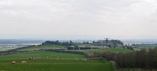
Eddisbury hill fort, also known as Castle Ditch, is an Iron Age hill fort near Delamere, Cheshire, in northern England. Hill forts are fortified hill-top settlements constructed across Britain during the Iron Age. Eddisbury is the largest and most complex of the seven hill forts in the county of Cheshire. It was constructed before 200–100 BC and expanded in 1–50 AD. In the 1st century AD, the Romans slighted the site. It was reoccupied in the 6th–8th centuries AD, and an Anglo-Saxon burh was probably established at Eddisbury in 914. In the medieval and post-medieval periods quarrying and farming have damaged the site. Ownership is currently split between the Forestry Commission and a local farm. Eddisbury is protected as a Scheduled Ancient Monument.

Moel y Gaer, Rhosesmor

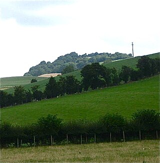
Moel y Gaer is an Iron Age hillfort located on a summit at the southern end of Halkyn Mountain, overlooking the village of Rhosesmor, Flintshire, Wales. It is a well-preserved hillfort overlooking the Dee Estuary. Excavations in the early 1970s revealed a sequence of defensive structures made of timber and several phases of building work inside the ramparts.

Moel y Gaer, Llanbedr Iron Age hillfort in Denbighshire, Wales

Moel y Gaer, also known as Moel-y-Gaer Camp or Moel y Gaer Hillfort, is an Iron Age hillfort located on a western spur of the Clwydian Range, near the village of Llanbedr, Denbighshire, Wales. The site is a scheduled monument, classified as a prehistoric defensive hillfort.

Caer y Twr

Caer y Twr is an Iron Age hillfort atop the summit of the Holyhead Mountain in Anglesey, Wales.

Buckland Rings

Buckland Rings is the site of an Iron Age hill fort in the town of Lymington, Hampshire. Today, the mounds and dykes around the outside which once constituted its defences are still clearly visible, although the outer bank lies under the road on the west side, and on the south-east it is nearly ploughed-out. Excavations of the inner and middle ramparts in 1935 revealed that they were of wall-and-fill construction, retained at the front by upright timber beams and walls of cut and laid turf. The entrance, which lies on the east side, was also excavated revealing a long entrance passage and the postholes for a pair of stout gateposts. The site was bought by Hampshire County Council in 1989 to ensure its preservation, and it is open to the public from the A337 road onto which part of it faces.

Blewburton Hill Hillfort in Oxfordshire, England

Blewburton Hill is the site of an Iron Age hillfort located in Oxfordshire, in the southeast of England. It was a univallate hillfort. The area is mostly farmland with some small areas of wooded copse to the south and the northeast. The hill fort may have been occupied from the 4th century BC to the 1st century BC, and replaced a small settlement surrounded by a stockade, which is estimated to have been built in the 5th or 6th century BC.

Battlesbury Camp

Battlesbury Camp is the site of an Iron Age bivallate hill fort on Battlesbury Hill near the town of Warminster in Wiltshire, South West England. Excavations and surveys at the site have uncovered various finds and archaeological evidence.

The Dinas Powys hillfort is an Iron Age hillfort near Dinas Powys, Glamorgan, Wales. It is just one of several thousand hillforts to have been constructed around Great Britain during the British Iron Age, for reasons that are still debatable. The main fort at Dinas Powys was constructed on the northernmost point of the hill in either the third or 2nd century BCE, with two further constructs, known as the Southern Banks, being built further down on the southern end of the hill in the following 1st century BCE. It appears that occupation at the site ceased during the period of Roman Britain, but was re-inhabited by an Early Mediaeval settlement in the 5th century CE, who constructed further additions to the fort. The site was subsequently excavated by a team of archaeologists led by Leslie Alcock from 1954 through to 1958.

Bratton Castle

Bratton Castle is a bivallate Iron Age built hill fort on Bratton Down, at the western edge of the Salisbury Plain escarpment. The hill fort comprises two circuits of ditch and bank which together enclose a pentagonal area of 9.3 hectares.

Promontory forts of Cornwall

Cornish promontory forts, commonly known in Cornwall as cliff castles, are coastal equivalents of the hill forts and Cornish "rounds" found on Cornish hilltops and slopes. Similar coastal forts are found on the north–west European seaboard, in Normandy, Brittany and around the coastlines of the British Isles, especially in Wales, Scotland and Ireland. Many are known in southwest England, particularly in Cornwall and its neighbouring county, Devon. Two have been identified immediately west of Cornwall, in the Isles of Scilly.

Ffridd Faldwyn, Montgomery

Ffridd Faldwyn is an Iron Age hillfort in northern Powys, in the former county of Montgomeryshire, It is sited on a prominent hill west of Montgomery, close to but higher than Montgomery Castle, overlooking the River Severn. It is one of the largest hill-forts in Wales.

Caer Drewyn

Caer Drewyn is an early Iron Age hillfort to the north of the town of Corwen, Denbighshire. It has a large stone rampart with entrances on the west and north sides; there is a guard chamber within the north-east entrance, and it has a deep defensive ditch.

Parciau hill fort Roman period hill fort on Anglesey

Parciau hill fort is a hill fort on the Welsh island of Anglesey. It stands on the summit of Bryn Ddiôl, whose name means "trackless hill".

Braich-y-Dinas

Braich-y-Dinas was an extensive hillfort at the summit of Penmaenmawr, one of the northernmost peaks of the Carneddau mountain range on North coast of Wales. It was once considered the best preserved and most complete hillfort in North-West Wales, but completely disappeared in the first half of the 20th century due to a massive quarrying effort by the Darbishire family; which overwhelmed and eventually destroyed all traces of it, despite efforts by the Royal Commission to save the site.

Caer Bach

Caer Bach is a Welsh hillfort of indeterminate age, on a rounded hillock situated near the village of Rowen; in Conwy County, North Wales. Its name in English translates as 'Small Fort'; or alternatively 'Little Fortress'. It is situated on the Eastern slopes of Tal-y-Fan, an outlying peak of the Carneddau mountain range in northeast Snowdonia; at an altitude of approximately 413 metres. Little information is known about the history of the fort, as to date, the site has undergone minimal investigation. The fort is classed as a scheduled ancient monument and is of national importance for its potential to enhance our knowledge of prehistoric settlement. It is said to retain significant archaeological potential, with a strong probability of the presence of associated archaeological features and deposits.

Caer Euni

Caer Euni [Grid reference SJ 00027 41266] is an Iron Age hillfort, about 2.5 miles (4 km) north-east of the village of Llandderfel and about 5 miles (8 km) north-east of Bala Lake, in Gwynedd, Wales. It is a scheduled monument.

References

  1. Smith, George (22 August 2012). "RE-ASSESSMENT OF TWO HILLFORTS IN NORTH WALES: PEN-Y-DINAS, LLANDUDNO AND CAER SEION, CONWY" (PDF). Archaeology in Wales: 8–15. Retrieved 6 October 2017.
  2. 1 2 3 Cadw. "Castell Caer Lleion (CN012)". National Historic Assets of Wales . Retrieved 6 October 2017.
  3. 1 2 An Inventory of the Ancient Monuments in Caernarvonshire: I East: the Cantref of Arllechwedd and the Commote of Creuddyn, Volume 2. The Royal Commission On Ancient Historical Monuments in Wales and Monmouthshire. 1960. pp. 70–72. Retrieved 6 October 2017.
  4. 1 2 3 "This text is reproduced under the Non-Commercial Government Licence for public sector information".
  5. Smith, George (22 August 2012). "RE-ASSESSMENT OF TWO HILLFORTS IN NORTH WALES: PEN-Y-DINAS, LLANDUDNO AND CAER SEION, CONWY" (PDF). Archaeology in Wales: 8–15. Retrieved 6 October 2017.
  6. W.E. Griffiths, A.H.A. Hogg (1956). "The Hillfort on Conway Mountain, Caernarvonshire". Archaeologia Cambrensis, Journal of the Cambrian Archaeological Association. 105: 49. Retrieved 7 October 2017.
  7. "Castell Caer Seion;castell Caer Leion, Conwy Mountain (95279)". Coflein. RCAHMW . Retrieved 7 October 2017.
  8. "Snowdonia Heritage". Snowdonia Heritage. Retrieved 7 October 2017.
  9. Leland, John (1539). Leland's Itinerary in Wales. p. 84. Retrieved 7 October 2017.
  10. Smith, George (22 August 2012). "RE-ASSESSMENT OF TWO HILLFORTS IN NORTH WALES: PEN-Y-DINAS, LLANDUDNO AND CAER SEION, CONWY" (PDF). Archaeology in Wales: 8–15. Retrieved 6 October 2017.
  11. "Hill Fort On Conway Mountain, Caernarvonshir". Archaeologia Cambrensis. 105: 56. June 1956 via Llyfrgell Genedlaethol Cymru – The National Library of Wales.
  12. Harold Picton, W. Bezant Lowe (June 1909). "Journal of Cambrian Archaeology". Archaeologia Cambrensis. Llyfrgell Genedlaethol Cymru – The National Library of Wales. 9 (6th Series): 500–504. Retrieved 7 October 2017.
  13. Smith, George (22 August 2012). "RE-ASSESSMENT OF TWO HILLFORTS IN NORTH WALES: PEN-Y-DINAS, LLANDUDNO AND CAER SEION, CONWY" (PDF). Archaeology in Wales: 8–15. Retrieved 6 October 2017.
  14. "Hill Fort On Conway Mountain, Caernarvonshire". Archaeologia Cambrensis. 105: 49–80. June 1956 via Llyfrgell Genedlaethol Cymru – The National Library of Wales.
  15. "The Iron Age: Architecture". From Dot to Domesday. Archived from the original on 27 June 2017. Retrieved 9 October 2017.
  16. 1 2 "The Hill Fort at Conway Mountain, Caernarvonshire". Archaeologia Cambrensis. Llyfrgell Genedlaethol Cymru – The National Library of Wales. 105: 63. 1956. Retrieved 8 October 2017.
  17. "Archaeologia Cambrensis, Journal of the Cambrian Archaeological Association". 105. Llyfrgell Genedlaethol Cymru – The National Library of Wales. 1956: 76–80.{{cite journal}}: Cite journal requires |journal= (help)