A motte-and-bailey castle is a European fortification with a wooden or stone keep situated on a raised area of ground called a motte, accompanied by a walled courtyard, or bailey, surrounded by a protective ditch and palisade. Relatively easy to build with unskilled labour, but still militarily formidable, these castles were built across northern Europe from the 10th century onwards, spreading from Normandy and Anjou in France, into the Holy Roman Empire, as well as the Low Countries it controlled, in the 11th century, when these castles were popularized in the area that became the Netherlands. The Normans introduced the design into England and Wales. Motte-and-bailey castles were adopted in Scotland, Ireland, and Denmark in the 12th and 13th centuries. By the end of the 13th century, the design was largely superseded by alternative forms of fortification, but the earthworks remain a prominent feature in many countries.

New Radnor is a village and community in Powys, Wales. It is south of Radnor Forest, and was historically the county town of Radnorshire.

Wiston Castle is a motte and bailey castle in the Pembrokeshire village of Wiston in south west Wales and is one of the best examples of its type in Wales. The castle and village were founded by Wizo, a Flemish settler who was granted the land by Henry I of England after he had wrested control from the previous owner, Arnulf de Montgomery. The castle was captured by the Welsh on several occasions but on each occasion it was retaken. It was abandoned during the thirteenth century when the then owner moved to nearby Picton Castle.
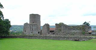
Tretower Castle is a Grade I-listed ruined castle in the village of Tretower in the county of Powys, Wales. It was built around the beginning of the twelfth century as a motte and bailey castle and this was probably replaced mid-century by a stone shell keep. The castle was enlarged in the early thirteenth century, but later fell into ruin.

Llandre, or Llanfihangel Genau'r Glyn, is a village in Ceredigion, Wales. It lies 5 miles north of Aberystwyth in the north-west of the county, on the road from Rhydypennau to Borth. To the north of the community lies the village of Dôl-y-bont. The community is called Geneu'r Glyn.

Llanfechain is a village and community in Powys, Wales, on the B4393 road between Llanfyllin and Llansantffraid-ym-Mechain. Historically it belonged to Montgomeryshire. The River Cain runs through. The population of 465 at the 2011 Census was estimated at 476 in 2019.

Mold Castle, also known as Bailey Hill in the town of Mold, Flintshire, north-east Wales, is a motte-and-bailey castle erected around 1072, probably by the Norman Robert de Montalt under instructions from Hugh d'Avranches, Earl of Chester. Little remains except the mound on which the motte was built. It stands close to the 15th-century parish church, St Mary's Church near the centre of the town.

Bryncrug, sometimes spelt Bryn-crug, is a village and community in Gwynedd, Wales. Afon Fathew flows through the village and into the River Dysynni. The village is situated to the north east of the town of Tywyn, at the junction of the A493 and B4405 roads. Although the village is usually spelt Bryncrug in English, the community name uses the Welsh language version, Bryn-crug. The population of the community taken at the 2011 census was 622.
Lampeter Castle, sometimes known as Stephen's Castle, was built during the Norman expansion into Wales at the end of the eleventh century. The motte is in the grounds of Lampeter University but the precise whereabouts of the bailey is unknown. It was captured by Cadell ap Gruffydd in 1146.

Ystrad Peithyll is the remains of a small 12th-century motte-and-bailey castle on the River Peithyll, near Penrhyn-coch in northern Ceredigion, Wales. The castle was attacked and destroyed by followers of Gruffydd ap Rhys in the early 12th century.
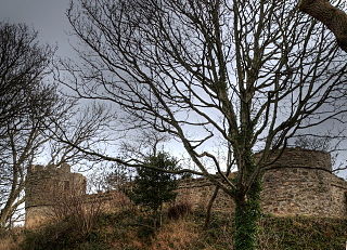
Castell Aberlleiniog is a motte and bailey fortress near the Welsh village of Llangoed on the Isle of Anglesey, built between 1080 and 1099 by Hugh d'Avranches, 1st Earl of Chester. It is about two miles distant from Beaumaris Castle, and was built atop a very steep hill.
Bleddfa Castle was a motte and bailey structure near Llangunllo in modern-day Powys, Wales. It is believed to have been built before 1195 and abandoned by 1304. What remains today is described as a "mutilated oval mound" of 46 by 36 metres, containing some traces of masonry. It is surrounded by a rectangular bailey measuring 100 by 60 metres, with a hedge on its northern border.
Buddugre Castle was a motte and bailey defensive fortification overlooking the River Ithon, located in the community of Llanddewi Ystradenny, in Radnorshire, Wales. It is believed to have been built as a defensive measure in the medieval period, during the 12th century, as a timber castle.

Builth Castle was a castle built under King Edward I, just outside Builth Wells, Powys, Wales. At one time it was an impressive stone-built castle but all the masonry has been removed over the years and all that remains are the mound on which it stood, the ditches and embankments.

Tregrug Castle or Llangibby Castle is a ruin in Monmouthshire, Wales, located about 1 mile (1.5 km) to the north of the village of Llangybi, close to the settlement of Tregrug.

Twmpath Castle, also known as Twmpath Motte, is a medieval motte on the southern slope of Wenallt Hill near Rhiwbina in Cardiff, Wales, which is a scheduled monument.

Ruperra Motte, also known as Craig Ruperra Motte, is a medieval motte and bailey castle in the community of Rudry close to the village of Draethen in the Caerphilly County Borough on the border with Newport in south west Wales. It is a Scheduled Monument within the Grade II listed Registered Historic Park & Garden, which also includes Ruperra Castle.

Snodhill Castle is a ruined motte-and-bailey castle, about 1 mi (1.6 km) south of the village of Dorstone in west Herefordshire, England. It is recognized as one of the major castles of the Welsh Marches. It was built in the 11th century to secure the border between Norman England and the Welsh Princes. Archaeological excavations show that it was one of the first Norman castles in England to have stone-built fortifications, with more sophisticated defenses being added in later centuries.

Llanthomas Castle Mound was built by the Normans after the 1066 Norman conquest of England but before 1215. It is a first-generation motte and bailey castle design; the building materials were earth and timber.
