Castiglione di Garfagnana

Last updated
Castiglione di Garfagnana
Comune di Castiglione di Garfagnana
CastiglioneDiGarfagnanaPanorama2.jpg
Location of Castiglione di Garfagnana
Castiglione di Garfagnana
Italy provincial location map 2016.svg
Red pog.svg
Castiglione di Garfagnana
Location of Castiglione di Garfagnana in Italy
Italy Tuscany location map.svg
Red pog.svg
Castiglione di Garfagnana
Castiglione di Garfagnana (Tuscany)
Coordinates: 44°09′N10°25′E / 44.150°N 10.417°E / 44.150; 10.417
Country Italy
Region Tuscany
Province Lucca (LU)
Frazioni Boccaia, Campori, Casone di Profecchia, Cerageto, Chiozza, Col d'Arciana, Filippe, Isola, Pegaia, Passo Radici, Pian di Cerreto, Mozzanella, Pozzatelle, Prunaccio, San Pellegrino in Alpe, Valbona
Government
  MayorDaniele Gaspari
Area
[1]
  Total48.53 km2 (18.74 sq mi)
Elevation
545 m (1,788 ft)
Population
 (31 March 2017) [2]
  Total1,790
  Density37/km2 (96/sq mi)
Demonym Castiglionesi
Time zone UTC+1 (CET)
  Summer (DST) UTC+2 (CEST)
Postal code
55033
Dialing code 0583
Patron saintMadonna del Carmine
Saint dayJuly 16
Website www.comune.castiglione-di-garfagnana.lu.it

Castiglione di Garfagnana is a medieval walled town and comune of 1,878 inhabitants in the province of Lucca. It sits on a hillside above the river Esarulo, a tributary of the Serchio.

Contents

The town is renowned for the band Filarmonica Alpina, founded in 1858 with the name of Fanfara popolare. It is one of I Borghi più belli d'Italia ("The most beautiful villages of Italy"). [3]

History

The origin of the town dates back to a Roman castra, called Castrum Leonis, ("Lion's Castle"), built to command the valley that leads to the San Pellegrino Pass, the easiest access for armies over the Apennines. The fortress later developed under the Lombard and Frank dominations.

In 1170 it was besieged by the Republic of Lucca. Castiglione surrendered, but the high taxes imposed led the city to form a league with other communes of Garfagnana against Lucca.

In 1227 Castiglione was again besieged and suffered further destruction by Lucchese soldiers. Political conflicts continued in the following years, until a peace was reached in 1371: Lucca gained definitive control of Castiglione, and established a permanent administrator. The defensive structure was upgraded with the widening of the town walls.

During the 15th century Castiglione was one of the few communities in Garfagnana that did not submit to the Este family, instead remaining loyal to the Republic of Lucca. Throughout the wars against the Estensi, the fortress was again besieged, in particular in 1603 and 1613. There then followed a long period of peace, marred only by boundary disputes with the neighbouring communes.

The Congress of Vienna (1815) assigned Castiglione to Marie Louise of Bourbon, Grand Duchess of Lucca, who in 1819 gave it to Francis IV of Modena.

Main sights

Castiglione's most striking attraction is the Medieval bridge built by Spinetta Malaspina in the 13th century. The town is also famous for its well-preserved 13th-century medieval walls with large towers (the Torrioni) and the castle (Rocca).

The church of San Pietro was erected in 723 by two Lombard brothers, Aurinand and Gudifrid, but was largely rebuilt in the 12th century by Bishop Guido III of Lucca. San Michele (14th century) is the other main holy building of the town. Both churches use wall towers as their belfries.

The Church of San Pellegrino (in the frazione of the same name), at 1,400 metres (4,600 ft) and commanding the valley of the Serchio river, houses the mortal remains of St. Pellegrino and St. Bianco.

The town has a panoramic vista over the valley below.

Sister cities

Related Research Articles

<span class="mw-page-title-main">Montalcino</span> Comune in Tuscany, Italy

Montalcino is a hill town and comune in the province of Siena, Tuscany, central Italy.

<span class="mw-page-title-main">Lucca</span> City and comune in Tuscany, Italy

Lucca is a city and comune in Tuscany, Central Italy, on the Serchio River, in a fertile plain near the Ligurian Sea. The city has a population of about 89,000, while its province has a population of 383,957.

The Garfagnana is a historical and geographical region of central Italy, today part of the province of Lucca, in Tuscany. It is the upper valley or basin of the river Serchio, and thus lies between the main ridge of the Northern Apennines to the north-east and the Alpi Apuane to the west. The principal towns are Castelnuovo di Garfagnana and Barga.

<span class="mw-page-title-main">Iseo, Lombardy</span> Comune in Lombardy, Italy

Iseo is a town and comune in the province of Brescia, in Lombardy, Italy, on the south shore of Lake Iseo. It is bounded by the communes of Provaglio d'Iseo, Sulzano, Polaveno and Paratico.

<span class="mw-page-title-main">Montagnana</span> Comune in Veneto, Italy

Montagnana is a town and comune in the province of Padova, in Veneto. Neighbouring communes are Borgo Veneto, Casale di Scodosia, Urbana, Bevilacqua, Pojana Maggiore, Pressana, Minerbe and Roveredo di Guà. As of 2017, the population of Montagnana is 9120. The town was awarded with the Bandiera arancione and is one of I Borghi più belli d'Italia.

<span class="mw-page-title-main">Province of Lucca</span> Province of Italy

The province of Lucca is a province in the Tuscany region of Italy. Its capital is the city of Lucca.

<span class="mw-page-title-main">Barga, Tuscany</span> Comune in Tuscany, Italy

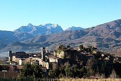
Barga is a medieval town and comune of the province of Lucca in Tuscany, central Italy. It is home to around 10,000 people and is the chief town of the "Media Valle" of the Serchio River. It is one of I Borghi più belli d'Italia.

<span class="mw-page-title-main">Serchio</span> River in Italy

The Serchio is the third longest river in the Italian region of Tuscany at 126 kilometres (78 mi), coming after the Arno at 242 kilometres (150 mi) and the Ombrone, 161 kilometres (100 mi). By mean rate of flow, it is the second largest, smaller than Arno but larger than Ombrone.

<span class="mw-page-title-main">Bagni di Lucca</span> Comune in Tuscany, Italy

Bagni di Lucca is a comune of Tuscany, Italy, in the Province of Lucca with a population of about 6,100. The comune has 27 named frazioni (wards).

<span class="mw-page-title-main">Castelnuovo di Garfagnana</span> Comune in Tuscany, Italy

Castelnuovo di Garfagnana is a town and comune in the province of Lucca, Toscana, central Italy. It is located at the confluence of the Serchio and the Turrite Secca rivers, close to the intersection of roads passing through the Apennine Mountains and the Apuan Alps.

<span class="mw-page-title-main">Fosciandora</span> Comune in Tuscany, Italy

Fosciandora is a comune (municipality) of 554 inhabitants in the Province of Lucca in the Italian region Tuscany, located about 70 kilometres (43 mi) northwest of Florence and about 30 kilometres (19 mi) north of Lucca.

<span class="mw-page-title-main">Gallicano</span> Comune in Tuscany, Italy

Gallicano is a comune (municipality) in the Province of Lucca in the Italian region Tuscany, located about 70 kilometres (43 mi) northwest of Florence and about 25 kilometres (16 mi) northwest of Lucca.

<span class="mw-page-title-main">Piazza al Serchio</span> Comune in Tuscany, Italy

Piazza al Serchio is a comune (municipality) in the Province of Lucca in the Italian region Tuscany, located about 90 kilometres (56 mi) northwest of Florence and about 40 kilometres (25 mi) northwest of Lucca.

Firenzuola is a comune (municipality) in the Metropolitan City of Florence, in the Italian region Tuscany, located about 40 kilometres (25 mi) northeast of Florence.

<span class="mw-page-title-main">Bibulca Way</span>

Bibulca Way was an old road dating back to the 11th century that used to link up Modena with Lucca and it was part of a much bigger network of roads. It starts where the Dragone River flows into the Dolo River in the La Piana locality and finishes at San Pellegrino in Alpe, a hamlet located on the ridge that separates the Tuscan from the Emilian Apennines. It was also called the Imperial Way due to its high toll that had to be paid in order to use it and that it could host a cart drawn by two oxen one beside the other, a luxury for the time. It has a length of 30 kilometers, starting from a height of 360 metres and arriving at a height of 1,529 metres. Now it is used as an amateur trekking path that runs alongside the Strada provinciale 32MO road and in certain stretches shares the same route.

<span class="mw-page-title-main">Lugliano</span> Frazione in Tuscany, Italy

Lugliano is a small frazione (village) located in the municipality of Bagni di Lucca, in the Province of Lucca, Tuscany.

<span class="mw-page-title-main">Sanctuary of San Pellegrino in Alpe</span> Religious Sanctuary in Alpe, Italy

The Santuario di San Pellegrino in Alpe or Santi Pellegrino e Bianco is a Roman Catholic church and adjacent hostel-hospital complex on a hilltop within the town limits of Castiglione di Garfagnana, province of Lucca, region of Tuscany, Italy. It lies in a rural site along the Bibulca Way.

San Pellegrino may refer to:

References

  1. "Superficie di Comuni Province e Regioni italiane al 9 ottobre 2011". Italian National Institute of Statistics. Retrieved 16 March 2019.
  2. "Popolazione Residente al 1° Gennaio 2018". Italian National Institute of Statistics. Retrieved 16 March 2019.
  3. "Toscana" (in Italian). Retrieved 1 August 2023.