
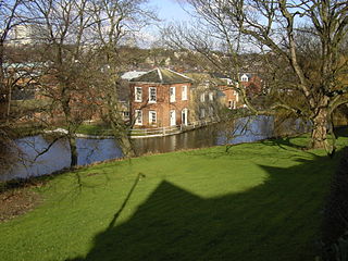
The River Sheaf in Sheffield, South Yorkshire, England, flows northwards, past Dore, through Abbeydale and north of Heeley. It then passes into a culvert, through which it flows under the centre of Sheffield before joining the River Don. This lower section of the River Sheaf, together with the River Don between the Blonk Street and Lady's Bridges, formed two sides of the boundary of Sheffield Castle.
The Porter Brook is a river which flows through the City of Sheffield, England, descending over 1,000 feet (300 m) from its source on Burbage Moor to the west of the city to its mouth where it joins the River Sheaf in a culvert beneath Sheffield railway station. Like the other rivers in Sheffield, its steep gradient made it ideal for powering water mills and works associated with the metalworking and cutlery industries, and around 20 dams were constructed over the centuries to facilitate this. At its lower end, it is extensively culverted, but parts of it are gradually being restored to open channels, as part of a daylighting scheme for the city.

Stockton-on-Tees, often simply referred to as Stockton, is a market town in County Durham, England. It is on the northern banks of the River Tees, part of the Teesside built-up area. The town had an estimated population of 84,318 in 2011.

The A57 is a major road in England. It runs east from Liverpool to Lincoln via Warrington, Cadishead, Irlam, Patricroft, Eccles, Salford and Manchester, then through the Pennines over the Snake Pass, around the Ladybower Reservoir, through Sheffield and past Worksop. Between Liverpool and Glossop, the road has largely been superseded by the M62, M602 and M67 motorways. Within Manchester a short stretch becomes the Mancunian Way, designated A57(M).

Sheffield Castle was a castle in Sheffield, England, constructed at the confluence of the River Sheaf and the River Don, possibly on the site of a former Anglo-Saxon long house, and dominating the early town. A motte and bailey castle had been constructed on the site at some time in the century following the Norman Conquest of England in 1066. This was destroyed in the Second Barons' War. Construction of a second castle, this time in stone, began four years later in 1270.

Castle Square is the plaza at the intersection of High Street, Angel Street, and Arundel Gate in the City of Sheffield, England. This name was given to the square in the 1960s to reflect the proximity of the square to the site of Sheffield Castle, which was formerly located a short distance to the north-east.

City ward — which includes the districts of Highfield, Kelham Island and the city centre — is one of the 28 electoral wards in City of Sheffield, England. It covers the central area of the city. The ward was created following the 2015 local government boundary review out of part of the old Central ward, which, with a population of 36,412, was the largest ward in the UK. City is one of the wards that make up the Sheffield Central constituency.
Sheffield is a geographically diverse city in England. It nestles in the eastern foothills of the Pennines and the confluence of five rivers: Don, Sheaf, Rivelin, Loxley and Porter. As such, much of the city is built on hillsides, with views into the city centre or out to the countryside. The city is roughly one third urban, one third rural and one third in the Peak District. At its lowest point the city stands just 29 metres above sea level at Blackburn Meadows on the Rotherham border, rising up to over 500 m in some parts of the city to a peak of 548m at High Stones on the Derbyshire border; however, 89% of the housing in the city is between 100 and 200 metres above sea level. Over 95% of the population resides in the main urban area.
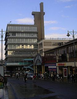
Castle Market was an indoor market in Sheffield city centre, England. The building lay in the north east of the present city centre, by the River Don, and was built on top of the remains of Sheffield Castle, which could still be seen via guided tours. The market closed in 2013 when the Moor Market opened on The Moor, further south in Sheffield city centre, and demolition began in 2015.

Sheaf House was a nine-storey tower building by Sheaf Square, next to Sheffield railway station, in the centre of Sheffield, in South Yorkshire, England. The building was formerly the Sheffield area headquarters of British Rail.

Sheaf Square is a municipal square lying immediately east of the city centre of Sheffield, England.
Sheffield City Centre is a district of the City of Sheffield and is covered partly by the City ward of the City of Sheffield. It includes the area that is within a radius of roughly 0.75 miles (1.2 km) of Sheffield Cathedral and is encircled by the Inner Ring Road, a circular route started in the late 1960s and completed in 2007. As well as the cathedral, buildings in the city centre include the Grade I listed Town Hall, the City Hall and the Winter Gardens. Several areas of the city centre have been designated as quarters. It is home to the city's major business, transport, leisure and cultural attractions.
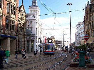
High Street is one of the main thoroughfares and shopping areas in the city centre of Sheffield in South Yorkshire, England, located at the approximate grid reference of SK356874. High Street starts at the Commercial Street, Fitzalan Square and Haymarket junction and runs for approximately 400 metres west to conclude near the Sheffield Cathedral where it forms a Y-junction with Fargate and Church Street. High Street has the traditional wide variety of shops, financial institutions and eating places which are associated with any British town centre.

Sheffield Inner Ring Road is a dual-carriageway circling central Sheffield, South Yorkshire, England. Marked up as the A61 all the way around, it was built from the 1960s onwards. The Ring Road connects to the Sheffield Parkway, which itself connects with the M1 motorway. Many of Sheffield's current and under construction major office premises and luxury apartments are located on the Ring Road.

The Moor Quarter is one of Sheffield's twelve designated quarters, built around and named for The Moor, a pedestrianised thoroughfare. It is bound by Furnival Gate in the north-east, Eyre Street in the south-east, St Mary's Gate to the south, and Moore Street and Charter Row to the north-west.

The A631 is a road running from Sheffield, South Yorkshire to Louth, Lincolnshire in England. It passes through the counties of South Yorkshire, Nottinghamshire and Lincolnshire. The road has many towns on its route including Rotherham, Maltby, Gainsborough and Market Rasen. It is mostly single road throughout its length but has some stretches of dual carriageway as well.
Sheaf Valley Quarter is an area in the centre of Sheffield, England. It is one of Sheffield's 11 designated City Centre Quarters, situated around the rail station and River Sheaf. Its borders are Commercial Street and a bowstring bridge to the north, the railway line to the east, Granville Road to the south (excluding Granville Square, Suffolk Road, Sheaf Square and Howard Street to the south west and Arundel Gate to the west. It is named after the River Sheaf, which flows from the south of the city, underneath the current station and into the River Don and Castlegate. It is one of only 2 quarters with some land outside the ring road.
Arundel Gate is one of the main thoroughfares in Sheffield, England. It is located in the Heart of the City area of Sheffield City Centre. Arundel Gate also features a fifteen-stand bus station, including a ticket office building, completed in 2005.

Tower Street is a road in the city centre of York, in England.

Kings Tower is an approved skyscraper that will be located on Castle Square at the junction of High Street and Angel Street in Sheffield, South Yorkshire. With a planned height of 120 m (390 ft) once completed, Kings Tower will overtake Code Sheffield as the tallest building in Sheffield and in Yorkshire. Plans for the tower were submitted by architects Hodder + Partners in September 2020, calling initially for a 39-storey tower. Planning permission was granted in December 2020, and construction is planned to complete in 2023. Amended plans were submitted in late 2022, adding a 40th floor to the project.
