Castleplunket

Last updated
The R377 road in Castleplunket R377 road in Castleplunket.jpg
The R377 road in Castleplunket
The R367 road in Castleplunket R367 road in Castleplunket.jpg
The R367 road in Castleplunket

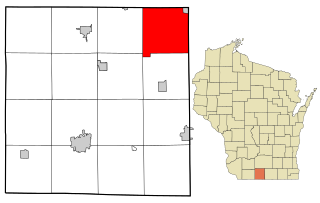
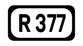
Castleplunket (Irish : Lios Lachna), [1] also spelled Castleplunkett, is a small village in County Roscommon, Ireland, situated at the junction of the R367 and R377 roads, some 10 km east of the town of Castlerea.

Irish language Goidelic (Gaelic) language spoken in Ireland and by Irish people

Irish is a Goidelic (Gaelic) language originating in Ireland and historically spoken by the Irish people. Irish is spoken as a first language in substantial areas of counties Galway, Kerry, Cork and Donegal, smaller areas of Waterford, Mayo and Meath, and a few other locations, and as a second language by a larger group of non-habitual speakers across the country.

County Roscommon County in the Republic of Ireland

County Roscommon is a county in Ireland. In the western region, it is part of the province of Connacht. It is the 11th largest Irish county by area and 27th most populous. Its county town and largest town is Roscommon. Roscommon County Council is the local authority for the county. The population of the county was 64,544 according to the 2016 census.

Republic of Ireland Ireland, a country in north-western Europe, occupying 5/6 of the island of Ireland; succeeded the Irish Free State (1937)

Ireland, also known as the Republic of Ireland, is a country in north-western Europe occupying 26 of 32 counties of the island of Ireland. The capital and largest city is Dublin, which is located on the eastern part of the island, and whose metropolitan area is home to around a third of the country's over 4.8 million inhabitants. The sovereign state shares its only land border with Northern Ireland, a part of the United Kingdom. It is otherwise surrounded by the Atlantic Ocean, with the Celtic Sea to the south, Saint George's Channel to the south-east, and the Irish Sea to the east. It is a unitary, parliamentary republic. The legislature, the Oireachtas, consists of a lower house, Dáil Éireann, an upper house, Seanad Éireann, and an elected President who serves as the largely ceremonial head of state, but with some important powers and duties. The head of government is the Taoiseach, who is elected by the Dáil and appointed by the President; the Taoiseach in turn appoints other government ministers.

Castleplunket has a National School, a number of businesses called Flanagan's (including a pub), and a village development association.

In the Republic of Ireland, a National school is a type of primary school that is financed directly by the State, but administered jointly by the State, a patron body, and local representatives. There are other forms of primary school, often private denominational schools attached to secondary schools – unlike their second level counterparts, these primary level private schools receive no support from the state.

The painter Roderic O'Conor (1860–1940) was born here.

Roderic OConor Irish artist

Roderic O'Conor was an Irish painter who spent much of his later career in Paris and as part of the Pont-Aven movement. O'Conor's work demonstrates Impressionist and Post-Impressionist influence.

See also

Related Research Articles

Arctic Archipelago Canadian archipelago

The Arctic Archipelago, also known as the Canadian Arctic Archipelago, is a group of islands north of the Canadian mainland.

Brooklyn, Green County, Wisconsin Town in Wisconsin, United States

Brooklyn is a town in Green County, Wisconsin, United States. The population was 1,083 at the 2010 census. The unincorporated community of Attica is located in the town. Section one of the Town of Brooklyn contains the portion of the village of Brooklyn that lies in Green County.

Clonfert human settlement

Clonfert is a small village in east County Galway, Ireland, halfway between Ballinasloe and Portumna. The village gives its name to the Diocese of Clonfert. Clonfert Cathedral is one of the eight cathedral churches of the Church of Ireland Diocese of Limerick and Killaloe. The cathedral of the Roman Catholic Diocese of Clonfert is located in Loughrea.

Ballyforan

Ballyforan is a village in south County Roscommon, Ireland on the R363 road between Ballygar and Dysart, County Roscommon. It lies beside the River Suck which separates County Roscommon and County Galway.

Kilconly is a small rural village near Tuam which is north of Galway City in County Galway, Ireland. It is situated about seven miles north west of Tuam town on the Ballinrobe road (R332).

Williamstown, County Galway

Williamstown is a small village located on the R360 regional road in the townland of Corralough in northeast County Galway, Ireland.

Shammer

Shammer is a small village beside the village of Kilkelly in County Mayo, Ireland.

R755 road (Ireland)

The R755 road is a regional road in Ireland. It runs for its entire length in County Wicklow. From the village of Kilmacanogue on the N11 national primary road it goes north/south for 36 km (22 mi) to the town of Rathdrum.

Drummin is a small village in County Mayo, Ireland, near the town of Westport.

Rathconrath

Rathconrath is a village in County Westmeath, Ireland. It is situated on the R392 regional road 12 km (7.5 mi) west of Mullingar.

Kilkerrin is a village in County Galway, Ireland. It is situated on the R364 regional road 6 km south of the town of Glenamaddy. Notable features in the area are Kiltullagh Lake and the Lough Lurgeen raised bog.

Tulrahan

Tulrahan, also spelt Tulrohaun, is a village in County Mayo, Ireland. It is located off the R327 regional road roughly midway between Claremorris and Cloonfad.

Staplestown is a village in North County Kildare, Ireland, located 40 kilometres west of Dublin. The village has a church, a school and is home to St Kevin's GAA.

Ballymacward

Ballymacward is a village in County Galway, Ireland, on the R359 regional road between the main road and rail networks which traverse east-west, 24 kilometres from Ballinasloe and approximately 48 kilometres from Galway City. It was once part of the kingdom of the Soghain of Connacht.

Castleblakeney village in County Galway, Ireland

Castleblakeney or Castleblakeny, historically Gallagh, is a village in County Galway, Ireland. It is at the crossroads of the R359 and R339 regional roads, 5km south of the town of Mountbellew.

Moylough

Moylough is a small rural village located in County Galway in Ireland. It is located on the N63 national secondary road, and is served also by the R328 and R364 regional roads. It is 50 km from Galway, 30 km from Roscommon, and 5 km northwest of Mountbellew. It is twinned with Elliant in Brittany.

Drumraney is a village in the County Westmeath, Ireland, just off the R390 regional road between Athlone and Mullingar. It is part of a small parish with a population of approximately 242 which includes the nearby village of Tang. It is approximately 12 km from Athlone.

R377 road (Ireland)

The R377 road is a regional road in north County Roscommon in Ireland. It connects the R367 road at Castleplunket to the N60 road at Castlerea. The R377 is 11.4 kilometres (7.1 mi) long.

German submarine <i>U-959</i> German world war II submarine

German submarine U-959 was a Type VIIC U-boat of Nazi Germany's Kriegsmarine during World War II.

References

  1. Castleplunket Placenames Database of Ireland. Retrieved: 2012-04-08.

Coordinates: 53°45′N8°20′W / 53.750°N 8.333°W / 53.750; -8.333

Geographic coordinate system Coordinate system

A geographic coordinate system is a coordinate system that enables every location on Earth to be specified by a set of numbers, letters or symbols. The coordinates are often chosen such that one of the numbers represents a vertical position and two or three of the numbers represent a horizontal position; alternatively, a geographic position may be expressed in a combined three-dimensional Cartesian vector. A common choice of coordinates is latitude, longitude and elevation. To specify a location on a plane requires a map projection.