
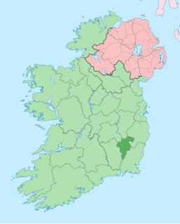
County Wicklow is a county in Ireland. The last of the traditional 32 counties to be formed, as late as 1606, it is part of the Mid-East Region and also part of the traditional province of Leinster. It is named after the town of Wicklow, which derives from the Old Norse name Víkingaló, meaning "Vikings' Meadow". Wicklow County Council is the local authority for the county. The county had a population of 142,425 at the 2016 census.
County Carlow is a county located in the South-East Region of Ireland, within the province of Leinster. Carlow is the second smallest and the third least populous of Ireland's 32 traditional counties. Carlow County Council is the governing local authority.
Wicklow is the county town of County Wicklow in Ireland. Located south of Dublin on the east coast of the island, it has a population of 10,584 according to the 2016 census. The town is to the east of the M11 route between Dublin and Wexford. Wicklow is also linked to the rail network, with Dublin commuter services now extending to the town. Additional services connect with Arklow, Wexford and Rosslare Europort, a main ferry port. There is also a commercial port, mainly importing timber and textiles. The River Vartry is the main river which flows through the town.
Ogham is an Early Medieval alphabet used primarily to write the early Irish language, and later the Old Irish language. There are roughly 400 surviving orthodox inscriptions on stone monuments throughout Ireland and western Britain; the bulk of which are in southern Munster. The largest number outside Ireland are in Pembrokeshire, Wales.

Carnaross or Carnaros is a village in County Meath, Ireland, approximately 4 km northwest of Kells on the R147 road between Kells and Virginia, County Cavan.
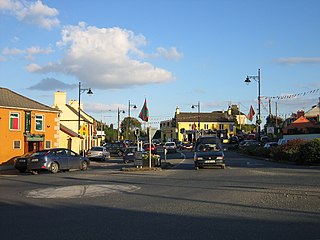
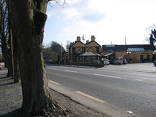
Rathnew is a village in County Wicklow, Ireland. Located south of the capital Dublin along the M11 between Dublin and Wexford, it is close to the county town of Wicklow, which is situated 3 km (1.9 mi) to the east.

Roughly 400 known ogham inscriptions are on stone monuments scattered around the Irish Sea, the bulk of them dating to the fifth and sixth centuries. Their language is predominantly Primitive Irish, but a few examples record fragments of the Pictish language. Ogham itself is an Early Medieval form of alphabet or cipher, sometimes known as the "Celtic Tree Alphabet".

2RN is the trading name of RTÉ Transmission Network Ltd, a wholly owned subsidiary of Raidió Teilifís Éireann, formerly trading as RTÉNL, which runs Ireland's principal digital terrestrial television and radio broadcast networks. In December 2002 it became an incorporated company and subsidiary of RTÉ, it was previously a division within RTÉ. It operates 12 main TV and radio transmitter sites and many smaller relays and transposers, which carry television and/or radio. It also provides site hosting for mobile telephone operators, the emergency services, wireless broadband and other private mobile communications service providers.

Brittas Bay in County Wicklow, Ireland is a 4 kilometres (2.5 mi) stretch of beach on the Irish Sea coast, about 12 kilometres (7.5 mi) south of Wicklow. The beach and associated dunes are very popular with Dubliners and are one of the most frequented beaches by residents of the capital during the summer.
Brittas is a rural village in the jurisdiction of South Dublin, just north of the border with County Wicklow on the N81 road.

The R750 road is a regional road in County Wicklow, Ireland. From its junction with the R772 in Rathnew on the outskirts of Wicklow Town it takes a generally southerly route to its junction with the R772 in Ferrybank in Arklow, where it terminates.
Killeen Cormac, aka Cell Fine Chormaic, is an early ecclesiastical site in County Kildare, Ireland.

The R114 road is a regional road in south Dublin, Ireland. The road runs from the city centre to Brittas in remote southwest County Dublin via Rathmines, Rathgar, Rathfarnham, Knocklyon, Firhouse and the mountainous area of Boharnabreena. The final stretch of the road runs just north of the border between County Dublin and County Wicklow, parallel to the Brittas River and a canal to the River Camac, which rises just to the north.

Kilbride, or Manor Kilbride, is a village, civil parish and District electoral division in County Wicklow, Ireland, located at the western edge of the Wicklow Mountains in the barony of Talbotstown Lower.

The Piper's Stones or the Athgreany stone circle is a Bronze Age stone circle at Athgreany, County Wicklow. It sits on a low hillock overlooking the N81, 2 km south of Hollywood.

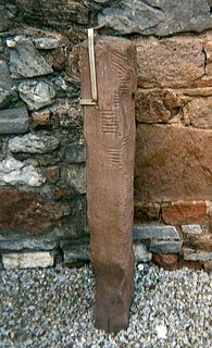
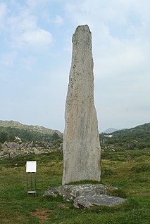
Crossoona Rath[krɪʃˈuːnə] is a ringfort located in County Wicklow, Ireland. Together with a nearby ogham stone, it forms a National Monument.
Ballycrovane Ogham Stone is an ogham stone and National Monument located in County Cork, Ireland.
The Tullygarran ogham stones are a pair of ogham stones forming a National Monument located in County Kerry, Ireland.

Ballywiheen is a medieval Christian site and National Monument located on the Dingle Peninsula, Ireland.
