Related Research Articles

The Thousand Islands constitute a North American archipelago of 1,864 islands that straddles the Canada–US border in the Saint Lawrence River as it emerges from the northeast corner of Lake Ontario. They stretch for about 50 miles (80 km) downstream from Kingston, Ontario. The Canadian islands are in the province of Ontario and the U.S. islands in the state of New York.

Brockville, formerly Elizabethtown, is a city in Eastern Ontario, Canada, in the Thousand Islands region. Although it is the seat of the United Counties of Leeds and Grenville, it is politically independent of the county. It is included with Leeds and Grenville for census purposes only.
The Cataraqui River forms the lower portion of the Rideau Canal and drains into Lake Ontario at Kingston, Ontario. The name is taken from the original name for Kingston, Ontario; its exact meaning, however, is undetermined. Early maps showed several name variations including the Great Cataraqui River and Grand River Cataraquay. The river was once called Riviere de Frontenac, or Frontenac River. The alternate spelling "Cadaraqui" also appears in some historic texts.
The United Counties of Leeds and Grenville, commonly known as Leeds and Grenville, is a county in Ontario, Canada, in the Eastern Ontario subregion of Southern Ontario. It fronts on the Saint Lawrence River and the international boundary between Canada and the United States, opposite of the State of New York. The county seat is Brockville. The county was formed by the union of the historical counties of Leeds and Grenville in 1850.

The Gananoque River is a river in Leeds and Grenville United Counties in Eastern Ontario, Canada. The river is in the Atlantic Ocean drainage basin and is a left tributary of the Saint Lawrence River.
Elizabethtown-Kitley is a township in eastern Ontario, Canada, in the United Counties of Leeds and Grenville. Its southern border lies along the St. Lawrence River and it extends north into many rural hamlets and villages. The township was created on January 1, 2001, by the amalgamation of the former Township of Elizabethtown and Township of Kitley.
Leeds County is a historic county in the Canadian province of Ontario. The county was first surveyed in 1792 as one of the nineteen counties created by Sir John Graves Simcoe in preparation for the United Empire Loyalists to settle here. The county took its name from Francis Osborne, 5th Duke of Leeds; the "Leeds" of the Dukedom referred to Leeds in West Yorkshire, England and not for Leeds, Kent, England. In 1850, Leeds County merged with Grenville County to create the United Counties of Leeds and Grenville. This county was home to several townships as well as the city of Brockville.
Loughborough Lake is a lake in Eastern Ontario, Canada. The lake is mostly in the municipality of South Frontenac, Frontenac County, except for the southern tip which is in and on the northern border of the separated city of Kingston, and is about 20 kilometres (12 mi) north of the town centre of Kingston.
A conservation authority is a local, community-based natural resource management agency based in Ontario, Canada. Conservation authorities represent groupings of municipalities on a watershed basis and work in partnership with other agencies to carry out natural resource management activities within their respective watersheds, on behalf of their member municipalities and the Province of Ontario.
Conservation Ontario is the network of Ontario’s 36 conservation authorities in Ontario, Canada. Conservation Authorities are local, watershed management agencies that deliver services and programs that protect and manage water and other natural resources in partnership with government, landowners and other organizations.
Little Cataraqui Creek Conservation Area is a 394-hectare (970-acre) conservation area located north of the city of Kingston, Ontario, Canada, and is managed by the Cataraqui Region Conservation Authority.
Credit Valley Conservation (CVC) is one of 36 conservation authorities in Ontario, Canada, responsible for protecting, restoring, and managing natural resources at the watershed level. CVC operates within the Credit River watershed and smaller adjacent watersheds that drain directly into Lake Ontario, as well as along a section of the Lake Ontario shoreline. Together, these areas make up CVC's jurisdiction. CVC is a member of Conservation Ontario.
Lemoine Point Conservation Area is a 136-hectare (340-acre) recreational conservation area at the west end of Kingston, Ontario. The area is bordered by Collins Bay on the north and west sides, Lake Ontario on the south and Kingston/Norman Rogers Airport on the east.
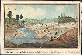
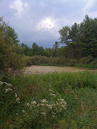
Buell's Creek Reservoir is an anthropogenic reservoir north of Brockville, Ontario, in Mac Johnson Wildlife Area. It can be accessed from Debruge Road. There is a 2.7 kilometre walking trail around the lake that is accessible from Centennial Road.
The Mac Johnson Wildlife Area is a 532-hectare (1,310-acre) wildlife area north of Brockville, Ontario, Canada, that includes wetland, fields, and forest land, as well as a reservoir that maintains water levels for the Buells Creek watershed flowing through the Township of Elizabethtown-Kitley and the City of Brockville. The wildlife area is managed by the Cataraqui Region Conservation Authority (CRCA). The area is open to visitors and offers 11 km (6.8 mi) of walking paths through woodland, wetland and open fields.

Gould Lake Conservation Area is a rural conservation area located in the Canadian Shield northwest of the community of Sydenham in the Township of South Frontenac, Frontenac County, in eastern Ontario, Canada. The area was created to manage water resources, preserve wildlife habitat, and provide recreational and educational opportunities, and is managed by the Cataraqui Region Conservation Authority. The conservation area contains much of Gould Lake.

The Railway Museum of Eastern Ontario, a rail museum in a former CNoR station, stands on the abandoned right-of-way of a Canadian Northern Railway line which once led southwest toward Napanee. Established 1985 as the Smiths Falls Railway Museum, the RMEO works to preserve the 1913 Canadian Northern (CNoR) station and a collection of historic rolling stock, equipment and railway memorabilia.

The Bay of Quinte Railway was a short-line railway in eastern Ontario, Canada. It was formed as the Napanee, Tamworth and Quebec Railway (NT&QR), chartered in 1878 by Edward Rathbun and Alexander Campbell, with plans to run from Napanee through Renfrew County and on to the Ottawa Valley. Lacking funding from the governments, development never began.
The Loyal Rangers, or Jessup's Loyal Rangers, was a volunteer regiment of Loyalists in the American Revolution.

Millhaven Creek is a stream in the municipalities of Loyalist, Lennox and Addington County, and South Frontenac, Frontenac County, and the single-tier municipality of Kingston in eastern Ontario, Canada. It is a tributary of Lake Ontario and is under the auspices of the Cataraqui Region Conservation Authority.
References
- ↑ "Ontario's 36 Conservation Authorities". Conservation Ontario. 2021-01-25. Archived from the original on 2013-08-09. Retrieved 2021-01-25.
- ↑ "Who We Are". Cataraqui Conservation. Retrieved 2021-01-25.
