
Erosion is the action of surface processes that removes soil, rock, or dissolved material from one location on the Earth's crust and then transports it to another location where it is deposited. Erosion is distinct from weathering which involves no movement. Removal of rock or soil as clastic sediment is referred to as physical or mechanical erosion; this contrasts with chemical erosion, where soil or rock material is removed from an area by dissolution. Eroded sediment or solutes may be transported just a few millimetres, or for thousands of kilometres.
Soil erosion is the denudation or wearing away of the upper layer of soil. It is a form of soil degradation. This natural process is caused by the dynamic activity of erosive agents, that is, water, ice (glaciers), snow, air (wind), plants, and animals. In accordance with these agents, erosion is sometimes divided into water erosion, glacial erosion, snow erosion, wind (aeolian) erosion, zoogenic erosion and anthropogenic erosion such as tillage erosion. Soil erosion may be a slow process that continues relatively unnoticed, or it may occur at an alarming rate causing a serious loss of topsoil. The loss of soil from farmland may be reflected in reduced crop production potential, lower surface water quality and damaged drainage networks. Soil erosion could also cause sinkholes.

Geomorphology is the scientific study of the origin and evolution of topographic and bathymetric features generated by physical, chemical or biological processes operating at or near Earth's surface. Geomorphologists seek to understand why landscapes look the way they do, to understand landform and terrain history and dynamics and to predict changes through a combination of field observations, physical experiments and numerical modeling. Geomorphologists work within disciplines such as physical geography, geology, geodesy, engineering geology, archaeology, climatology, and geotechnical engineering. This broad base of interests contributes to many research styles and interests within the field.
Soil formation, also known as pedogenesis, is the process of soil genesis as regulated by the effects of place, environment, and history. Biogeochemical processes act to both create and destroy order (anisotropy) within soils. These alterations lead to the development of layers, termed soil horizons, distinguished by differences in color, structure, texture, and chemistry. These features occur in patterns of soil type distribution, forming in response to differences in soil forming factors.

Aeolian processes, also spelled eolian, pertain to wind activity in the study of geology and weather and specifically to the wind's ability to shape the surface of the Earth. Winds may erode, transport, and deposit materials and are effective agents in regions with sparse vegetation, a lack of soil moisture and a large supply of unconsolidated sediments. Although water is a much more powerful eroding force than wind, aeolian processes are important in arid environments such as deserts.
Colluvium is a general name for loose, unconsolidated sediments that have been deposited at the base of hillslopes by either rainwash, sheetwash, slow continuous downslope creep, or a variable combination of these processes. Colluvium is typically composed of a heterogeneous range of rock types and sediments ranging from silt to rock fragments of various sizes. This term is also used to specifically refer to sediment deposited at the base of a hillslope by unconcentrated surface runoff or sheet erosion.

Grey dunes are fixed, stable sand dunes that are covered by a continuous layer of herbaceous vegetation. These dunes are typically located 50–100 meters from the ocean shore and are found on the landward side of foredunes. Grey dunes are named for their characteristic grey color which is a result of the ground cover of lichen combined with a top soil layer of humus.
Drainage density is a quantity used to describe physical parameters of a drainage basin. First described by Robert E. Horton, drainage density is defined as the total length of channel in a drainage basin divided by the total area, represented by the following equation:
In hillslope geomorphology, a rill is a shallow channel cut into soil by the erosive action of flowing surface water. Similar but smaller incised channels are known as microrills; larger incised channels are known as gullies.

Terra rossa is a well-drained, reddish, clayey to silty soil with neutral pH conditions and is typical of the Mediterranean region. The reddish color of terra rossa is the result of the preferential formation of hematite over goethite. This soil type typically occurs as a discontinuous layer that ranges from a few centimeters to several meters in thickness that covers limestone and dolomite bedrock in karst regions. The high internal drainage and neutral pH conditions of terra rossa are a result of the karstic nature of the underlying limestone and dolomite. Terra rossa is also found associated with Mediterranean climates and karst elsewhere in the world.

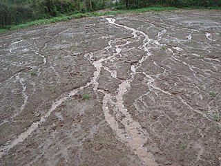
Sheet erosion or sheet wash is the even erosion of substrate along a wide area. It occurs in a wide range of settings such as coastal plains, hill slopes, floodplains, beaches, savanna plains and semi-arid plains. Water moving fairly uniformly with a similar thickness over a surface is called sheet flow, and is the cause of sheet erosion. Sheet erosion implies that any flow of water that causes the erosion is not canalized. If a hillslope surface contains many irregularities, sheet erosion may give way to erosion along small channels called rills, which can then converge forming gullies. However, sheet erosion may occur despite some limited unevenness in the sheet flow arising from clods of earth, rock fragments, or vegetation.

Bank erosion is the wearing away of the banks of a stream or river. This is distinguished from erosion of the bed of the watercourse, which is referred to as scour.
The soil biomantle can be described and defined in several ways. Most simply, the soil biomantle is the organic-rich bioturbated upper part of the soil, including the topsoil where most biota live, reproduce, die, and become assimilated. The biomantle is thus the upper zone of soil that is predominantly a product of organic activity and the area where bioturbation is a dominant process.
The Water Erosion Prediction Project (WEPP) model is a physically based erosion simulation model built on the fundamentals of hydrology, plant science, hydraulics, and erosion mechanics. The model was developed by an interagency team of scientists to replace the Universal Soil Loss Equation (USLE) and has been widely used in the United States and the world. WEPP requires four inputs, i.e., climate, topography, soil, and management (vegetation); and provides various types of outputs, including water balance, soil detachment and deposition at points along the slope, sediment delivery, and vegetation growth. The WEPP model has been improved continuously since its public delivery in 1995, and is applicable for a variety of areas.

Traditionally in geomorphology, a flatiron is a steeply sloping triangular landform created by the differential erosion of a steeply dipping, erosion-resistant layer of rock overlying softer strata. Flatirons have wide bases that form the base of a steep, triangular facet that narrows upward into a point at its summit. The dissection of a hogback by regularly spaced streams often results in the formation of a series of flatirons along the strike of the rock layer that formed the hogback. As noted in some, but not all definitions, a number of flatirons are perched upon the slope of a larger mountain with the rock layer forming the flatiron inclined in the same direction as, but often at a steeper angle than the associated mountain slope. The name flatiron refers to their resemblance to an upended, household flatiron.
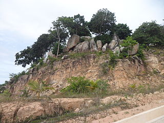
In geology and geomorphology, an erosion surface is a surface of rock or regolith that was formed by erosion and not by construction nor fault displacement. Erosional surfaces within the stratigraphic record are known as unconformities, but not all unconformities are buried erosion surfaces. Erosion surfaces vary in scale and can be formed on a mountain range or a rock. Particularly large and flat erosion surfaces receive the names of peneplain, paleoplain, planation surface or pediplain. An example of erosion surface is road surface erosion which is caused by natural and anthropogenic factors. Erosion surface can be measured through direct, contact measurement methods and indirect, non-contact measurement methods.
Hillslope evolution is the changes in the erosion rates, erosion styles and form of slopes of hills and mountains over time.
Legacy sediment (LS) is depositional bodies of sediment inherited from the increase of human activities since the Neolithic. These include a broad range of land use and land cover changes, such as agricultural clearance, lumbering and clearance of native vegetation, mining, road building, urbanization, as well as alterations brought to river systems in the form of dams and other engineering structures meant to control and regulate natural fluvial processes (erosion, deposition, lateral migration, meandering). The concept of LS is used in geomorphology, ecology, as well as in water quality and toxicological studies.

Tillage erosion is a form of soil erosion occurring in cultivated fields due to the movement of soil by tillage. There is growing evidence that tillage erosion is a major soil erosion process in agricultural lands, surpassing water and wind erosion in many fields all around the world, especially on sloping and hilly lands A signature spatial pattern of soil erosion shown in many water erosion handbooks and pamphlets, the eroded hilltops, is actually caused by tillage erosion as water erosion mainly causes soil losses in the midslope and lowerslope segments of a slope, not the hilltops. Tillage erosion results in soil degradation, which can lead to significant reduction in crop yield and, therefore, economic losses for the farm.

The Chinese Loess Plateau, or simply the Loess Plateau, is a plateau in north-central China formed of loess, a clastic silt-like sediment formed by the accumulation of wind-blown dust. It is located southeast of the Gobi Desert and is surrounded by the Yellow River. It includes parts of the Chinese provinces of Gansu, Shaanxi and Shanxi. The depositional setting of the Chinese Loess Plateau was shaped by the tectonic movement in the Neogene period, after which strong southeast winds caused by the East Asian Monsoon transported sediment to the plateau during the Quaternary period. The three main morphological types in the Loess Plateau are loess platforms, ridges and hills, formed by the deposition and erosion of loess. Most of the loess comes from the Gobi Desert and other nearby deserts. The sediments were transported to the Loess Plateau during interglacial periods by southeasterly prevailing winds and winter monsoon winds. After the deposition of sediments on the plateau, they were gradually compacted to form loess under the arid climate.


