Cato (village), New York

Last updated
Cato, New York
USA New York location map.svg
Red pog.svg
Cato
Location within the state of New York
Coordinates: 43°10′7″N76°34′25″W / 43.16861°N 76.57361°W / 43.16861; -76.57361
Country United States
State New York
County Cayuga
Town Cato
Area
[1]
  Total1.01 sq mi (2.62 km2)
  Land0.99 sq mi (2.56 km2)
  Water0.03 sq mi (0.06 km2)
Elevation
459 ft (140 m)
Population
 (2020)
  Total517
  Density522.75/sq mi (201.93/km2)
Time zone UTC-5 (Eastern (EST))
  Summer (DST) UTC-4 (EDT)
ZIP code
13033
Area code 315
FIPS code 36-12958
GNIS feature ID0946053
Website villageofcatony.com

Cato is a village in Cayuga County, New York, United States. The population was 532 at the 2010 census. [2] The name was assigned by the surveyors of the Military Tract, and is one of many towns and villages bearing classical place names. The village of Cato is half within the town of Cato and half within the town of Ira. It is west of Syracuse.

Contents

History

The village was part of the Central New York Military Tract, land set aside in 1782 for veterans of the American Revolution. Prior native occupants were compelled to live on reservations established at that time. The first permanent settler arrived around 1805, and the new community was called "Jakway's Corners".

Railroad service came to the village in 1869, aiding its prosperity, but rail service ended in 1953.

Cato is home to the 1993 Section 3 Class D state football champions. Modern Cato is partly a bedroom community, with many residents commuting to surrounding cities.

Geography

According to the United States Census Bureau, the village has a total area of 1.0 square mile (2.6 km2), of which 0.023 square miles (0.06 km2), or 2.44%, is water. [2]

The village is located in a drumlin field.

Parker Pond, formerly known as "Forest Lake", is a small lake at the southeast edge of the village. Muskrat Creek drains from the lake and flows southward to the Seneca River (and Erie Canal).

The village is at the junction of NY-34 and NY-370. Locating places within the village is extremely simple, since virtually all locations which may be visited by a non-resident are located on these two highways.

Water tower

The Cato water tower stands 120 feet (37 m) over the village of Cato, to the northeast of the village center. The light blue structure had been a landmark for 75 years or more but was to be torn down as of June 2012. The new water tower was to be dark blue on top and still say "Cato" on both sides. It will sit on 82 feet (25 m) of concrete. It will also be bigger, holding 25,000 extra gallons of water, in anticipation of future town growth.

Old Cato water tower
Summer 2012 Cato Water Tower.JPG
Old Cato water tower
Summer 2012
New Water Tower Winter 2017 New Water Tower Winter 2017.jpg
New Water Tower Winter 2017

Demographics

Historical population
CensusPop.Note
1880 313
1900 350
1910 3746.9%
1920 4048.0%
1930 403−0.2%
1940 4122.2%
1950 4314.6%
1960 47610.4%
1970 60126.3%
1980 475−21.0%
1990 58122.3%
2000 6013.4%
2010 532−11.5%
2020 517−2.8%
U.S. Decennial Census [3]

As of the census [4] of 2000, there were 601 people, 238 households, and 154 families residing in the village. The population density was 608.2 inhabitants per square mile (234.8/km2). There were 253 housing units at an average density of 256.0 per square mile (98.8/km2). The racial makeup of the village was 97.50% White, 0.33% Black or African American, 0.50% Native American, 0.33% from other races, and 1.33% from two or more races. Hispanic or Latino of any race were 0.50% of the population.

There were 238 households, out of which 35.3% had children under the age of 18 living with them, 51.3% were married couples living together, 11.3% had a female householder with no husband present, and 34.9% were non-families. 31.5% of all households were made up of individuals, and 19.7% had someone living alone who was 65 years of age or older. The average household size was 2.53 and the average family size was 3.15.

In the village, the population was spread out, with 29.5% under the age of 18, 6.3% from 18 to 24, 27.8% from 25 to 44, 19.3% from 45 to 64, and 17.1% who were 65 years of age or older. The median age was 38 years. For every 100 females, there were 87.8 males. For every 100 females age 18 and over, there were 80.4 males.

The median income for a household in the village was $35,938, and the median income for a family was $49,219. Males had a median income of $37,303 versus $26,250 for females. The per capita income for the village was $17,511. About 2.9% of families and 6.9% of the population were below the poverty line, including 5.5% of those under age 18 and 21.0% of those age 65 or over.

Related Research Articles

Cato Township is a civil township of Montcalm County in the U.S. state of Michigan. The population was 2,920 at the 2000 census.

<span class="mw-page-title-main">Lakeview, Michigan</span> Village in Michigan, United States

Lakeview is a village in Cato Township in Montcalm County of the U.S. state of Michigan. The population was 1,007 at the 2010 census. The village is within Cato Township.

<span class="mw-page-title-main">Machias, New York</span> Town in New York, United States

Machias is a town in Cattaraugus County, New York, United States. The population was 2,309 at the 2020 census. Machias is an interior town in the northeast quadrant of the county. It is northeast of the city of Salamanca.

<span class="mw-page-title-main">Aurelius, New York</span> Town in New York, United States

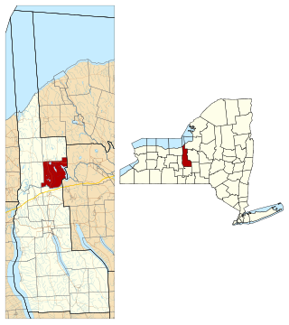
Aurelius is a town in Cayuga County, New York, United States. The population was 2,610 at the 2020 census. The town was named after the Roman emperor Marcus Aurelius. It is at the western edge of the county and borders the city of Auburn.

<span class="mw-page-title-main">Conquest, New York</span> Town in New York, United States

Conquest is a town in Cayuga County, New York, United States. The population was 1,796 at the 2020 census. The name was chosen to mark the victory of those who wished to form the town. Conquest is on the western border of Cayuga County and is west of Syracuse.

<span class="mw-page-title-main">Ira, New York</span> Town in New York, United States

Ira is a town in Cayuga County, New York, United States. The population was 2,145 at the 2020 census. The town is in the northern part of the county and is northwest of Syracuse.

<span class="mw-page-title-main">Sempronius, New York</span> Town in New York, United States

Sempronius is a town in Cayuga County, New York, United States. The population was 895 at the 2010 census. The town was named after a Roman military and political leader by Robert Harpur, a clerk interested in the classics. Sempronius is in the southeastern part of the county, southeast of Auburn.

<span class="mw-page-title-main">Sterling, New York</span> Town in New York, United States

Sterling is a town in Cayuga County, New York, United States. The population was 3,040 at the 2010 census. Located on the shore of Lake Ontario, the town is named after William Alexander, Lord Stirling, an American general of the Revolutionary War. Sterling is the most northerly town in the county and lies northwest of Syracuse.

<span class="mw-page-title-main">Victory, Cayuga County, New York</span> Town in New York, United States

Victory is a town in Cayuga County, New York, United States. The population was 1,660 at the 2010 census. The name celebrates the political victory in forming the town. It is in the northwestern part of the county and north of Auburn.

<span class="mw-page-title-main">Harford, New York</span> Town in New York, United States

Harford is a town in Cortland County, New York, United States. The population was 943 at the 2010 census. Harford is in the southwestern corner of Cortland County and is south of Cortland.

<span class="mw-page-title-main">Darien, New York</span> Town in New York, United States

Darien is a town in Genesee County, New York, United States. The population was 3,158 at the 2010 census. Darien lies in the southwestern part of Genesee County, southwest of Batavia.

<span class="mw-page-title-main">Greenwood Lake, New York</span> Village in New York, United States

Greenwood Lake is a village in Orange County, New York, United States, in the southern part of the town of Warwick. As of the 2020 census, the population of the village was 2,994. It is part of the Poughkeepsie–Newburgh–Middletown, NY Metropolitan Statistical Area as well as the larger New York–Newark–Bridgeport Combined Statistical Area.

Pulteney is a town in Steuben County, New York, United States. The population was 1,260 at the 2020 census. The name is derived from the name of the original pioneer tract of land.

<span class="mw-page-title-main">White Lake, North Carolina</span> Town in North Carolina, United States

White Lake is a town in Bladen County, North Carolina, United States. The population was 802 at the 2010 census, up from 529 in 2000.

<span class="mw-page-title-main">Lake, Price County, Wisconsin</span> Town in Wisconsin, United States

Lake is a town in Price County, Wisconsin, United States. The population was 1,319 at the 2000 census. The unincorporated community of Kennedy is located in the town. The ghost town of Kaiser was also located in the town.

<span class="mw-page-title-main">Lake City, Minnesota</span> City in Minnesota, United States

Lake City is a city in Goodhue and Wabasha counties in the U.S. state of Minnesota. It lies along Lake Pepin, a wide portion of the Mississippi River. The population was 5,063 at the 2010 census. Most of Lake City is located within Wabasha County with only a small portion in Goodhue County. Lake City is part of the Rochester, Minnesota Metropolitan Statistical Area.

<span class="mw-page-title-main">Cato (town), New York</span> Town in New York, United States

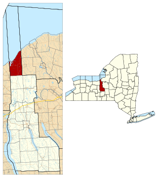
Cato is a town in Cayuga County, New York, United States. The population was 2,443 at the 2020 census. The town is named after Cato the Elder, a Roman statesman. The name was assigned by the surveyors of the Military Tract, and is one of many towns and villages bearing classical place names.

<span class="mw-page-title-main">Almena (town), Wisconsin</span>

The Town of Almena is in Barron County in the U.S. state of Wisconsin. The population was 858 at the 2010 census. The Village of Almena is partially located within the town.

Wittenberg is a town in Shawano County, Wisconsin, United States. As of the 2000 census, the town had a total population of 894. The Village of Wittenberg is located within the town. The unincorporated community of Whitcomb is also located within the town.

Fremont is a town in Waupaca County, Wisconsin, United States. The population was 632 at the 2000 census. The village of Fremont is located within the town. The unincorporated community of Red Banks is located in the town.

References

  1. "ArcGIS REST Services Directory". United States Census Bureau. Retrieved September 20, 2022.
  2. 1 2 "Geographic Identifiers: 2010 Demographic Profile Data (G001): Cato village, New York". U.S. Census Bureau, American Factfinder. Archived from the original on February 12, 2020. Retrieved November 14, 2014.
  3. "Census of Population and Housing". Census.gov. Retrieved June 4, 2015.
  4. "U.S. Census website". United States Census Bureau . Retrieved 2008-01-31.