
North Yorkshire is a ceremonial county in the Yorkshire and the Humber and North East regions of England. It borders County Durham to the north, the North Sea to the east, the East Riding of Yorkshire to the south-east, South Yorkshire to the south, West Yorkshire to the south-west, and Cumbria and Lancashire to the west. Northallerton is the county town. The county was historically part of Yorkshire.

The Borough of Stockton-on-Tees is a local government district with borough status which straddles the ceremonial counties of County Durham and North Yorkshire, England. Since 1996 its council has been a unitary authority, being a district council which also performs the functions of a county council. The borough had a population of 196,600 in 2021.

Stamford Bridge is a village and civil parish on the River Derwent in the East Riding of Yorkshire, England, approximately 5 miles (8 km) east of York and 22 miles (35 km) west of Driffield. The village sits astride an ancient ford on the River Derwent.

Old Catton is a suburban village and civil parish in the English county of Norfolk which lies 2 miles (3.2 km) to the north-east of central Norwich. The parish is bounded by the Norwich International Airport at Hellesdon to the west and Sprowston to the east. The northern boundary is with the village of Spixworth while the A1042 road forms the southern boundary. It covers an area of 2.33 km2 (0.90 sq mi) and had a population of 5,954 in 2,512 households at the 2001 census, increasing to a population of 6,108 in 2,666 households at the 2011 Census. For the purposes of local government, it falls within the district of Broadland. The village is twinned with the French commune of Lavaré.

Norwich North is a constituency in the House of Commons of the UK Parliament represented by Alice Macdonald, member of the Labour Party, after winning the seat in the 2024 general election.

Chapeltown is an area of Sheffield in South Yorkshire, England. It is the half way point between Barnsley and Sheffield approximately 7 miles from both. It is part of the civil parish of Ecclesfield. It is historically within the West Riding of Yorkshire. Up until April 1st 1974, Chapeltown was part of the Wortley Rural District, after which, it was made part of the new administrative county of South Yorkshire and the Sheffield City Council area.

Gate Helmsley is a village and civil parish in North Yorkshire, England, about seven miles east of York. The village lies on the border with the East Riding of Yorkshire.
Hessay is a village and civil parish in the unitary authority area of the City of York, in the ceremonial county of North Yorkshire, England 4.7 miles (7.5 km) west of York.

Topcliffe is a village and civil parish in North Yorkshire, England. The village is situated on the River Swale, on the A167 road and close to the A168. It is about 5 miles (8 km) south-west of Thirsk and 11 miles (18 km) south of the county town of Northallerton. It has a population of 1,489. An army barracks, with a Royal Air Force airfield enclosed within, is located to the north of the village.

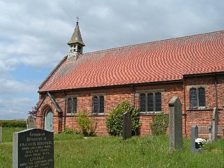
Skipton-on-Swale is a small village and civil parish in the Hambleton district of North Yorkshire, England. The population at the 2011 Census was less than 100. Details are included in the civil parish of Catton, North Yorkshire. It lies on the A61 road, about 4 miles west of Thirsk on the east bank of the River Swale.
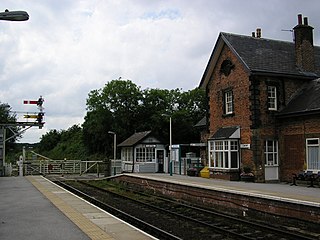
Cattal is a village and civil parish in the Borough of Harrogate district of North Yorkshire, England, about 6 miles (9.7 km) east of Knaresborough, and is located 12 miles (19 km) west of the city of York. Cattal is located on the River Nidd. Despite being a small village it is served by Cattal railway station on the Harrogate line ; the railway station generally provides an hourly service to the nearby cities of York and Leeds.

Wighill is a village and civil parish in the Harrogate district of North Yorkshire, England. It is near the River Wharfe and 6 miles (9.7 km) east of Wetherby, West Yorkshire. The village has one public house, the White Swan Inn, which reopened in 2009 after a two-year closure.

Catton is a civil parish in the East Riding of Yorkshire, England. It is situated 6 miles (10 km) to the north-west of the market town of Pocklington and covering an area of 1,233 hectares . It lies on the east bank of the River Derwent that forms the boundary with the unitary authority of the City of York. The A1079 road crosses the river just north of Kexby Old Bridge which is designated a Grade II* listed building in and is now recorded in the National Heritage List for England, maintained by Historic England.
Low Catton is a village and former civil parish, now in the parish of Catton, in the East Riding of Yorkshire, England. It is situated approximately 7 miles (11 km) north-west of the market town of Pocklington and about 1 mile (1.6 km) south of the village of Stamford Bridge. In 1931 the parish had a population of 85. Low Catton became a civil parish in 1866, on 1 April 1935 the parish was abolished and merged with High Catton to form "Catton".
High Catton is a village and former civil parish, now in the parish of Catton, in the East Riding of Yorkshire, England. It is situated approximately 6 miles (10 km) north-west of the market town of Pocklington and about 1 mile (1.6 km) south of the village of Stamford Bridge. The village of Low Catton and the River Derwent are 1 mile to the west. In 1931 the parish had a population of 174. From 1866 High Catton was a civil parish in its own right, on 1 April 1935 the parish was abolished and merged with Low Catton to form "Catton".

Walton-on-Trent is a village within the civil parish of Walton-upon-Trent, in the National Forest in the South Derbyshire district in Derbyshire, England. The population of the civil parish as taken at the 2011 Census was 872.

Catton is a civil parish within the South Derbyshire district, which is in the county of Derbyshire, England. Overwhelmingly rural, its population is reported alongside the adjacent parish of Coton in the Elms for a total of 896 residents in 2011. The parish is 100 miles (160 km) north west of London, 15 miles (24 km) south west of the county city of Derby, and 5 miles (8.0 km) south west of the nearest market town of Burton upon Trent. Being on the edge of the county border, it shares a boundary with the parishes of Coton in the Elms, Lullington and Walton upon Trent in Derbyshire, as well as Barton-under-Needwood, Edingale and Wychnor in Staffordshire. Catton Hall, a historic country house and the surrounding Catton Park are notable for hosting several annual events.
Catton is a civil parish in the South Derbyshire district of Derbyshire, England. The parish contains five listed buildings that are recorded in the National Heritage List for England. Of these, one is listed at Grade II*, the middle of the three grades, and the others are at Grade II, the lowest grade. The most important building in the parish is Catton Hall, which is listed at Grade II*. All the other listed buildings are associated with the hall, and consist of the kitchen garden walls, two stable ranges and a chapel.

