
Kincardineshire or the County of Kincardine, also known as the Mearns, is a historic county, registration county and lieutenancy area on the coast of northeast Scotland. It is bounded by Aberdeenshire on the north and west, and by Angus on the south.

The Mounth is the broad upland in northeast Scotland between the Highland Boundary and the River Dee, at the eastern end of the Grampians.

Kincardine and Mearns is one of six area committees of the Aberdeenshire council area in Scotland. It has a population of 38,506. There are significant natural features in this district including rivers, forests, mountains and bogs.

Findon is a fishing village eight miles south of Aberdeen, famous for originating the smoked haddock known as Finnan haddie. The Findon moor has a number of paths through it, many of which run along the cliffs. Deer can often be seen there. Nearby features include the Portlethen Moss Nature Reserve.

Portlethen Village is a settlement located to the east of Portlethen along the North Sea coast in Aberdeenshire, Scotland. The village is also known as Old Portlethen. The skerry of Craigmaroinn is situated just off the coastline near Portlethen Village.
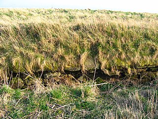
Red Moss is a wetland bog in Aberdeenshire, Scotland, located at the northwestern edge of the village of Netherley. The moss is designated a national Site of Special Scientific Interest by Scottish Natural Heritage, due to its biodiversity and undisturbed character. The elevation of Red Moss is 113 metres above mean sea level. The upland areas above Red Moss are characterised as agricultural and woodland parcels which are generally attractive and separated by ancient drystone walls or hedgerows.

Bridge of Muchalls is an entirely residential hamlet in Aberdeenshire, Scotland by the North Sea. It is next to the A92 dual carriageway about three miles north of Stonehaven and to the south of Muchalls Castle.
The Burn of Elsick is a coastal stream in Aberdeenshire, Scotland that discharges to the North Sea. This watercourse drains primarily agricultural lands and enters the North Sea at Newtonhill.
The Burn of Pheppie is an easterly flowing coastal stream in Aberdeenshire, Scotland that discharges to the North Sea immediately north of the village of Muchalls. Draining chiefly agricultural lands, this stream has a notable lack of turbidity and a pH level of approximately 8.02. Armouring of the stream bottom consists of pebbles, many of which are quartzite in composition, leading to a golden-green effect in some locations. Other nearby watercourses discharging to the North Sea include Burn of Elsick to the north and Burn of Muchalls to the south.

Elsick House is a historic house in Kincardineshire, North-East Scotland. It is situated in an agricultural area about two miles from the North Sea near the town of Newtonhill; the Elsick Estate is situated within the watershed of the Burn of Elsick, a stream that traverses the estate. The house is located on the Elsick Estate, and is the present family seat of the Duke of Fife.
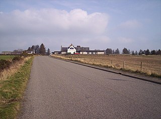
Cammachmore is a hamlet in the coastal region near the North Sea in Aberdeenshire. It lies slightly west of the A92 road and the ancient Causey Mounth passes through the community. Historic Elsick House is situated due west of Cammachmore. Other nearby historic features include Gillybrands, Saint Ternan's Church, Muchalls Castle and the Lairhillock Inn.
Cowie Castle is a ruined fortress in Aberdeenshire, Scotland. The site lies at the northern end of Stonehaven on the North Sea coast. To the immediate south is the Cowie Bridge crossing of the Cowie Water. Evidence of prehistoric man exists in the vicinity dating to the Iron Age in the form of ring cairns.

Banchory-Devenick is a hamlet approximately two kilometres south of the city of Aberdeen, Scotland in the Lower Deeside area of Aberdeenshire. The hamlet should not be confused with the historic civil parish of the same name which spanned the River Dee until 1891, its northern part lying in Aberdeenshire and its southern part in Kincardineshire. In that year the northern part became part of the neighbouring parish of Peterculter, the southern part remaining as the parish of Banchory-Devenick. The hamlet of Banchory-Devenick is on the B9077 road, and the ancient Causey Mounth passes directly through it. An historic graveyard dating to 1157 AD is present within Banchory-Devenick. Other historic features in the vicinity include Saint Ternan's Church, Muchalls Castle and the Lairhillock Inn.
Megray Hill is a low-lying coastal mountainous landform in Aberdeenshire, Scotland within the Mounth Range of the Grampian Mountains. The peak elevation of this mountain is 120 metres above mean sea level. This hill has been posited as a likely location for the noted Battle of Mons Graupius between the Romans and the indigenous Caledonians. The major Roman Camp of Raedykes is situated about three kilometres to the west. From Megray Hill there are expansive views to the North Sea facing east. The summit affords scenic views of the historic harbour of Stonehaven.

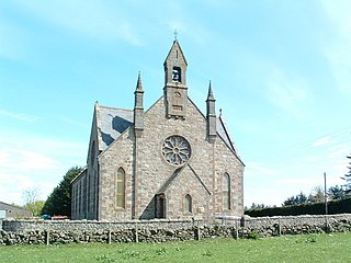
Saint Ternan's Church is an Episcopal church in the Diocese of Brechin, near Muchalls in Aberdeenshire, Scotland.

Cowie is an historic fishing village in Kincardineshire, Scotland. This village has existed since the Middle Ages, but in current times it is effectively subsumed into the town of Stonehaven. It had an estimated population of 2,720 in 2020.

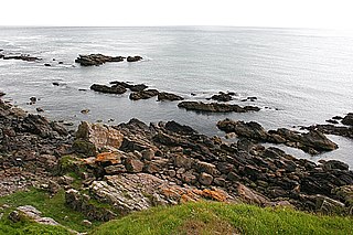
Grim Brigs is a rocky headland on the North Sea at Muchalls, Scotland. Notable historic features in this vicinity include St. Ternan's Church, Muchalls Castle and Elsick House. Approximately one kilometre inland is the noted medieval drovers' road known as the Causey Mounth. The geology of Grim Brigs is associated with the harder rock formations north of the Highland Boundary Fault, which forms the boundary between the Scottish Highlands and Lowlands. This Highland Boundary Fault emerges at the North Sea approximately four kilometres south of Grim Brigs near the Chapel of St. Mary and St. Nathalan.
Cookney Parish Church, now business premises within a converted listed building, was a Christian place of worship in the village of Cookney, Aberdeenshire, Scotland.
Craigmaroinn is a skerry in the North Sea near the Aberdeenshire coastline in Scotland. Craigmaroinn is situated midway between the coastal villages of Portlethen Village and Downies. Historical points of interest in the local area are Elsick House, Gillybrands and Muchalls Castle.

Hare Ness is a headland landform along the North Sea coastline a few miles south of Aberdeen, Scotland.


