
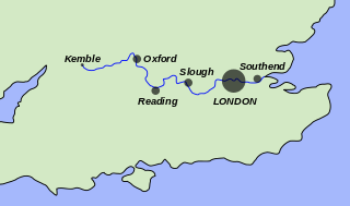
Reading is a town in Berkshire, England. Most of its built-up area lies within the Borough of Reading, although some outer suburbs are parts of neighbouring unitary authority areas. Located in the Thames Valley at the confluence of the rivers Thames and Kennet, Reading is 40 miles (64 km) east of Swindon, 24 miles (39 km) south of Oxford, 40 miles (64 km) west of London and 16 miles (26 km) north of Basingstoke.
The River Thames, known alternatively in parts as the River Isis, is a river that flows through southern England including London. At 215 miles (346 km), it is the longest river entirely in England and the second-longest in the United Kingdom, after the River Severn.

Henley-on-Thames is a town and civil parish on the River Thames in Oxfordshire, England, 9 miles (14 km) northeast of Reading, 7 miles (11 km) west of Maidenhead, 23 miles (37 km) southeast of Oxford and 37 miles (60 km) west of London, near the tripoint of Oxfordshire, Berkshire and Buckinghamshire. The population at the 2011 Census was 12,186.

Putney is a district of south London, England, in the London Borough of Wandsworth, five miles southwest of Charing Cross. The area is identified in the London Plan as one of 35 major centres in Greater London.
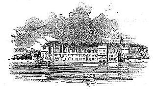
The Savoy Palace, considered the grandest nobleman's townhouse of medieval London, was the residence of prince John of Gaunt until it was destroyed during rioting in the Peasants' Revolt of 1381. The palace was on the site of an estate given to Peter II, Count of Savoy, in the mid-13th century, which in the following century came to be controlled by Gaunt's family. It was situated between the Strand and the River Thames. The Tudor-era Savoy Chapel was located on the former estate property and carried on the name; today, the name is carried on by the Savoy Theatre and Savoy Hotel, again both located on the former estate. In the locality of the palace, the administration of law was by a special jurisdiction, separate from the rest of the county of Middlesex, known as the Liberty of the Savoy. French monarch John II of France died here after an illness.

Datchet is a village and civil parish in the Royal Borough of Windsor and Maidenhead in Berkshire, England, located on the north bank of the River Thames. Historically part of Buckinghamshire, and the Stoke Hundred, the village was eventually transferred to Berkshire, under the Local Government Act of 1972. The village developed because of its close proximity to Windsor and the ferry service which connected it to the main London Road across the River Thames. The ferry was later replaced by a road bridge at the foot of the High Street, which was rebuilt three times. There is also a rail bridge approaching Windsor across the river, and two road bridges above and below the village.
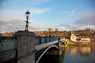
Windsor is a historic market town and unparished area in the Royal Borough of Windsor and Maidenhead in Berkshire, England. It is the site of Windsor Castle, one of the official residences of the British monarch. The town is situated 21.8 miles (35.1 km) west of Charing Cross, central London, 5.8 miles (9.3 km) southeast of Maidenhead, and 15.8 miles (25.4 km) east of the county town of Reading. It is immediately south of the River Thames, which forms its boundary with its smaller, ancient twin town of Eton. The village of Old Windsor, just over 2 miles (3 km) to the south, predates what is now called Windsor by around 300 years; in the past Windsor was formally referred to as New Windsor to distinguish the two.

Caversham is a suburb of Reading, England, located directly north of the town centre across the River Thames. Caversham rises from the River Thames, lying on flood plain and the lowest reaches of the Chiltern Hills. Two road bridges, including Caversham Bridge, and two footbridges join Caversham to the rest of Reading. Named areas within the suburb include Emmer Green, Lower Caversham, Caversham Heights and Caversham Park Village. Notable landmarks include Caversham Court, a public park and former country house; Caversham Lakes; and part of the Thames Path national trail.

Sonning is a village and civil parish in Berkshire, England, on the River Thames, east of Reading. The village was described by Jerome K. Jerome in his book Three Men in a Boat as "the most fairy-like little nook on the whole river".

Goring-on-Thames is a village and civil parish on the River Thames in South Oxfordshire, England, about 5+1⁄2 miles south of Wallingford and eight miles northwest of Reading. It had a population of 3,187 in the 2011 census, put at 3,335 in 2019. Goring & Streatley railway station is on the main Oxford–London line. Most land is farmland, with woodland on the Goring Gap outcrop of the Chiltern Hills. Its riverside plain encloses the residential area, including a high street with shops, pubs and restaurants. Nearby are the village churches – one dedicated to St Thomas Becket has a nave built within 50 years of the saint's death, in the early 13th century, along with a later bell tower. Goring faces the smaller Streatley across the Thames. The two are linked by Goring and Streatley Bridge.

Caversham Lock is a lock and main weir on the River Thames in England at Reading, Berkshire. Both the lock and main weir are connected to De Bohun Island. The Thames Navigation Commissioners built the original lock in 1778. Additional sluices north of View Island and Heron Island form the whole weir complex. A footbridge, known as The Clappers, passes over the weir and all three islands to connect Lower Caversham to Reading.

Pangbourne is a village and civil parish on the River Thames in Berkshire, England. Pangbourne has its own shops, schools, a railway station on the Great Western main line and a village hall. Outside its grouped developed area is an independent school, Pangbourne College.
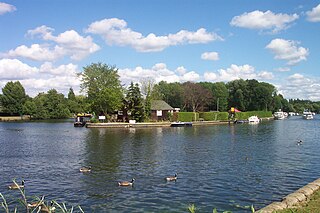
Fry's Island, also known as De Montfort Island, is an island in the River Thames in England. The island is on the reach above Caversham Lock at Reading, Berkshire. The centre of Reading is to the south and the suburb of Caversham to the immediate north.

Reading Bridge is a road bridge over the River Thames at Reading in the English county of Berkshire. The bridge links the centre of Reading on the south bank with the Lower Caversham area of the cross-river suburb, and former village, of Caversham on the north bank. It crosses the river a short way above Caversham Lock.

Remenham is a village and civil parish on the Berkshire bank of the River Thames opposite Henley-on-Thames in southern England. It is particularly well known for the steep approach, known as Remenham Hill or White Hill, into Henley.

Caversham Park is a Victorian-era stately home with parkland in the suburb of Caversham on the outskirts of Reading, England. Historically located in Oxfordshire, it became part of Berkshire with boundary changes in 1911. Caversham Park was home to BBC Monitoring and BBC Radio Berkshire. The park is listed as Grade II in the English Heritage Register of Historic Parks and Gardens.

Eye and Dunsden is a largely rural civil parish in the most southern part of the English county of Oxfordshire. It includes the villages of Sonning Eye, Dunsden Green and Playhatch and borders on the River Thames with the village of Sonning in Berkshire connected via multi-span medieval Sonning Bridge. Before 1866, Eye & Dunsden was part of the trans-county parish of Sonning.

Reading Rowing Club is a rowing club, on the River Thames in England, on the Berkshire bank at Reading close to the town centre just above Caversham Bridge, the westerly bridge in the town on the reach above Caversham Lock.

The following is a timeline of the history of Reading, the county town of Berkshire in England.


