Cedar River (Antrim County, Michigan)

Last updated
Cedar River
Country United States
Physical characteristics
Main source Chestonia Township
River mouth Intermediate River
614 ft (187 m) [1]
Basin features
River system Elk River Chain of Lakes Watershed

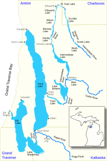
Cedar River is an 11.6-mile-long (18.7 km) [2] stream in Antrim County in the U.S. state of Michigan and is part of the Elk River Chain of Lakes Watershed, a tributary of Lake Michigan.

Antrim County, Michigan County in the United States

Antrim County is a county located in the U.S. state of Michigan. As of the 2010 United States Census, the population was 23,580. The county seat is Bellaire. The name is taken from County Antrim in Northern Ireland.

U.S. state constituent political entity of the United States

In the United States, a state is a constituent political entity, of which there are currently 50. Bound together in a political union, each state holds governmental jurisdiction over a separate and defined geographic territory and shares its sovereignty with the federal government. Due to this shared sovereignty, Americans are citizens both of the federal republic and of the state in which they reside. State citizenship and residency are flexible, and no government approval is required to move between states, except for persons restricted by certain types of court orders. Four states use the term commonwealth rather than state in their full official names.

Michigan State of the United States of America

Michigan is a state in the Great Lakes and Midwestern regions of the United States. The state's name, Michigan, originates from the Ojibwe word mishigamaa, meaning "large water" or "large lake". With a population of about 10 million, Michigan is the tenth most populous of the 50 United States, with the 11th most extensive total area, and is the largest state by total area east of the Mississippi River. Its capital is Lansing, and its largest city is Detroit. Metro Detroit is among the nation's most populous and largest metropolitan economies.

Contents

The Cedar River rises in southwest Chestonia Township at 44°57′29″N85°02′30″W / 44.95806°N 85.04167°W / 44.95806; -85.04167 (Cedar River (source)) [1] and flows mostly to the west into the Intermediate River in Bellaire at 44°58′48″N85°12′16″W / 44.98000°N 85.20444°W / 44.98000; -85.20444 (Cedar River (mouth)) . [1]

Chestonia Township, Michigan Civil township in Michigan, United States

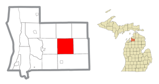
Chestonia Township is a civil township of Antrim County in the U.S. state of Michigan. The population was 511 at the 2010 census. From 1901 to 1932, the junction of the East Jordan and Southern and the Detroit & Charlevoix railroads lay within the township.

Bellaire, Michigan Village in Michigan, United States

Bellaire is a village in the U.S. state of Michigan. The population was 1,086 at the 2010 census. It is the county seat of Antrim County. The town has a very scenic main street, and is a popular location for tourists. Bellaire is also home to the Antrim County Courthouse, a historic structure built in 1905. The Antrim Review, the county's newspaper of record, is headquartered in Bellaire.

The North Branch Cedar River rises along the boundary between Chestonia and Kearney townships at 45°00′18″N85°06′04″W / 45.00500°N 85.10111°W / 45.00500; -85.10111 (North Branch Cedar River (source)) and flows southwest into the main branch about a mile east of Bellaire at 45°00′18″N85°06′04″W / 45.00500°N 85.10111°W / 45.00500; -85.10111 (North Branch Cedar River (mouth)) . [3]

Kearney Township, Michigan Civil township in Michigan, United States

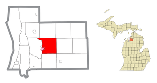
Kearney Township is a civil township of Antrim County in the U.S. state of Michigan. The population was 1,765 at the 2010 census.

Tributaries

From the mouth:

Drainage basin

The Cedar River drains portions of the following in Antrim County:

Custer Township, Antrim County, Michigan Civil township in Michigan, United States

Custer Township is a civil township of Antrim County in the U.S. state of Michigan. The population was 1,136 at the 2010 census.

Mancelona Township, Michigan Civil township in Michigan, United States

Mancelona Township is a civil township of Antrim County in the U.S. state of Michigan. The population was 4,400 at the 2010 census.

Related Research Articles

Ovid Township, Branch County, Michigan Township in Michigan, United States

Ovid Township is a civil township of Branch County in the U.S. state of Michigan. The population was 2,326 at the 2010 census.

The Jordan River is a 24.9-mile-long (40.1 km) stream in the northwestern part of the lower peninsula in the U.S. state of Michigan. It is the largest tributary of Lake Charlevoix. The Jordan's headwaters rise from springs in the upper Jordan River Valley northeast of Mancelona in Antrim County. The Jordan River was the first river to be designated in Michigan's Natural Rivers Program.

St. Joseph River (Maumee River tributary) tributary of the Maumee River in Ohio and Indiana

The St. Joseph River is an 86.1-mile-long (138.6 km) tributary of the Maumee River in northwestern Ohio and northeastern Indiana in the United States, with headwater tributaries rising in southern Michigan. It drains a primarily rural farming region in the watershed of Lake Erie.

Chippewa River (Michigan) river in Michigan

The Chippewa River is a stream in the U.S. state of Michigan that runs 91.8 miles (147.7 km) through the central Lower Peninsula. The Chippewa is a tributary of the Tittabawassee River and is thus part of the Saginaw River drainage basin. The river is named after the Chippewa people.

Carp River is a 40.2-mile-long (64.7 km) river in Chippewa and Mackinac counties in the U.S. state of Michigan. 21.7 miles (34.9 km) of the river were added to the National Wild and Scenic Rivers System in 1992.

Black River is a 15.5-mile-long (24.9 km) river in Alcona County in the U.S. state of Michigan. The main branch rises in northern Harrisville Township at 44°40′46″N83°22′15″W and flows north through Haynes Township and Alcona Township and empties into Lake Huron at 44°48′58″N83°17′57″W at the unincorporated community of Black River.

Black River (Southwest Michigan) river in southwest Michigan

Black River is a 4.2-mile-long (6.8 km) river in the southwest part of the U.S. state of Michigan that empties into Lake Michigan in South Haven at 42°24′08″N86°17′04″W, where it discharges past the South Pier Lighthouse. The river takes its name from the dark brown color of its water, which is caused by suspended sediments and organic materials picked up along its course. The river supports a variety of wildlife including trout, snapping turtles, leeches, and many other varieties of flora and fauna. The Black River watershed encompasses 287 square miles (740 km2) across two counties and 13 townships.

Black River is an 11.0-mile-long (17.7 km) river on the Upper Peninsula of the U.S. state of Michigan. The river flows into Lake Michigan at 46°05′37″N85°20′30″W, approximately 5 miles (8 km) east of Naubinway.

Cedar River (Gladwin County, Michigan) river in Clare and Gladwin counties, Michigan, United States

The Cedar River is a 29.0-mile-long (46.7 km) river in the U.S. state of Michigan, flowing through Clare County and Gladwin County.

Coldwater River is a 29.5-mile-long (47.5 km) stream in the U.S. state of Michigan. Located in Branch County, the river rises in Ovid Township at 41°50′14″N84°59′13″W as the outflow of Coldwater Lake. Flowing north and west, it is joined by the outflow from the Lake of the Woods and continues north for several miles. West of the city of Coldwater, it flows through a series of lakes: South Lake, Messenger Lake, Cemetery Lake, North Lake, Randall Lake, Morrison Lake, Craig Lake, and Hodunk Pond. It then continues to the northwest and empties into the St. Joseph River in the village of Union City at 42°03′58″N85°07′48″W.

Elk River Chain of Lakes Watershed

The Elk River Chain of Lakes Watershed is a 75-mile-long (121 km) waterway consisting of 14 lakes and connecting rivers in the northwestern section of the Lower Peninsula of the U.S. state of Michigan, which empty into Lake Michigan.

Cedar Creek may refer to several small streams in the U.S. state of Michigan:

Betsie River

The Betsie River is a 54.0-mile-long (86.9 km) stream in the northwest part of the U.S. state of Michigan. The name is derived from the French la rivière aux Bec-scies, meaning river of sawbill ducks (bec-scie). Other alternate names include Aug-sig-o-sebe, Aux Buscies, Betsey's River, Black Robe, Gay-she-say-ing, Riviere du Pere Marquette, Sawbill Ducks, and Shelldrake Ducks. The river is mostly within Benzie County, although the river rises in southwest Grand Traverse County and flows briefly through northern Manistee County, Michigan.

The Cataract River is a 1.9-mile-long (3.1 km) river in Newton Township, Mackinac County in the Upper Peninsula of the U.S. state of Michigan.

Hersey River river in Michigan, United States

The Hersey River is a 13.4-mile-long (21.6 km) stream in the Lower Peninsula of the U.S. state of Michigan. It rises in Lincoln Township in northwest Osceola County at the junction of Hersey Creek and the East Branch Hersey Creek at 43°50′55″N85°25′59″W. For approximately the first two miles, the river flows southward just east of U.S. Route 131. US 131 crosses the river near the northern boundary of Richmond Township. The river continues southward into Lake No Sho Mo, formed by a dam just south of Nartron Field airport. The river continues southward under U.S. Route 10 into Reed City and turns to the east, continuing southeastward into the village of Hersey, where it empties into the Muskegon River at Blodgett's Landing Campground.

Sturgeon River (Cheboygan County, Michigan) river in the U.S. state of Michigan, flowing mostly northward through Otsego and Cheboygan counties

Sturgeon River is a 40.8-mile-long (65.7 km) river in the U.S. state of Michigan, flowing mostly northward through Otsego and Cheboygan counties.

The Baldwin River is a 25.2-mile-long (40.6 km) stream in the U.S. state of Michigan.

Little Cedar River is a 56.7-mile-long (91.2 km) river in Menominee County in the U.S. state of Michigan.

References