Cedarville Township, Michigan

Last updated

Cedarville Township, Michigan
Sunset at J.W. Wells State Park.jpg
Sunset over Green Bay from Wells State Park
Cedarville Township, MI location2.png
Location within Menominee County and the state of Michigan
USA Michigan location map.svg
Red pog.svg
Cedarville Township
Usa edcp location map.svg
Red pog.svg
Cedarville Township
Coordinates: 45°29′00″N87°23′15″W / 45.48333°N 87.38750°W / 45.48333; -87.38750
Country United States
State Michigan
County Menominee
Area
[1]
  Total79.1 sq mi (205 km2)
  Land79.0 sq mi (205 km2)
  Water0.1 sq mi (0.3 km2)
Elevation
627 ft (191 m)
Population
 (2020) [2]
  Total242
  Density3.06/sq mi (1.18/km2)
Time zone UTC-6 (Central (CST))
  Summer (DST) UTC-5 (CDT)
ZIP Codes
Area code 906
FIPS code 26-109-14240 [3]
GNIS feature ID1626050 [4]

Cedarville Township is a civil township of Menominee County in the U.S. state of Michigan. The population was 242 as of the 2020 census. [2] The township was established in 1863. [5]

Contents

Geography

The township is in eastern Menominee County on the west shore of Lake Michigan's Green Bay. It is bordered to the northeast by Delta County. According to the United States Census Bureau, the township has a total area of 79.1 square miles (205 km2), of which 79.0 square miles (205 km2) are land and 0.1 square miles (0.26 km2), or 0.13%, are water. [1] Much of the land in the township is part of Escanaba River State Forest. The bulk of the township is drained by the Cedar River, including its tributary, the Walton River. The northeast part of the township is drained by Deer Creek and Olson Creek.

Communities

Demographics

As of the census [3] of 2000, there were 276 people, 138 households, and 89 families residing in the township. In 2020, there were 242 residents in the township. [2]

Related Research Articles

<span class="mw-page-title-main">Menominee County, Michigan</span> County in Michigan, United States

Menominee County is a county located in the Upper Peninsula in the U.S. state of Michigan. As of the 2020 census, the population was 23,502. The county seat is Menominee. The county's name comes from an American Indian word meaning "wild rice eater" used to describe a tribe. The county was created in 1861 from area partitioned out of Delta County, under the name of Bleeker. When county government was organized in 1863, the name was changed to Menominee.

<span class="mw-page-title-main">Delta County, Michigan</span> County in Michigan, United States

Delta County is a county in the Upper Peninsula in the U.S. state of Michigan. As of the 2020 census, the population was 36,903. The county seat is Escanaba. The county was surveyed in 1843 and organized in 1861. Its name originates from the Greek letter delta (Δ), which refers to the triangular shape of the original county which included segments of Menominee, Dickinson, Iron, and Marquette counties. Recreation and forest products are major industries, and crops include hay, corn, small grains, potatoes, and strawberries.

<span class="mw-page-title-main">Escanaba Township, Michigan</span> Civil township in Michigan, United States

Escanaba Township is a civil township of Delta County in the U.S. state of Michigan. The population was 3,482 at the 2010 census, down from 3,587 at the 2000 census.

<span class="mw-page-title-main">Breen Township, Michigan</span> Civil township in Michigan, United States

Breen Township is a civil township of Dickinson County in the U.S. state of Michigan. The population was 471 at the 2020 census.

<span class="mw-page-title-main">Sagola Township, Michigan</span> Civil township in Michigan, United States

Sagola Township is a civil township of Dickinson County in the U.S. state of Michigan. The population was 1,066 at the 2020 census.

<span class="mw-page-title-main">West Branch Township, Dickinson County, Michigan</span> Civil township in Michigan, United States

West Branch Township is a civil township of Dickinson County in the U.S. state of Michigan. The population was 51 at the 2020 census.

<span class="mw-page-title-main">Grattan Township, Michigan</span> Civil township in Michigan, United States

Grattan Township is a civil township of Kent County in the U.S. state of Michigan. As of the 2010 census, the township population was 3,621.

<span class="mw-page-title-main">Marion Township, Livingston County, Michigan</span> Civil township in Michigan, United States

Marion Township is a civil township of Livingston County in the U.S. state of Michigan. The population was 9,996 at the 2010 census, up from 6,757 at the 2000 census.

<span class="mw-page-title-main">Clark Township, Michigan</span> Civil township in Michigan, United States

Clark Township is a civil township of Mackinac County in the U.S. state of Michigan. As of the 2020 census, the population was 1,917, down from 2,256 in 2010.

<span class="mw-page-title-main">Gourley Township, Michigan</span> Civil township in Michigan, United States

Gourley Township is a civil township of Menominee County in the U.S. state of Michigan. The population was 451 at the 2020 census.

<span class="mw-page-title-main">Harris Township, Michigan</span> Civil township in Michigan, United States

Harris Township is a civil township of Menominee County in the U.S. state of Michigan. The population was 2,113 at the 2020 census.

<span class="mw-page-title-main">Ingallston Township, Michigan</span> Civil township in Michigan, United States

Ingallston Township is a civil township of Menominee County in the U.S. state of Michigan. The population was 924 at the 2020 census.

<span class="mw-page-title-main">Mellen Township, Michigan</span> Civil township in Michigan, United States

Mellen Township is a civil township of Menominee County in the U.S. state of Michigan. The population was 1,109 at the 2020 census. It is named after pioneer settler Mellen Smith (1829–1905), who served as the first postmaster at Wallace.

<span class="mw-page-title-main">Meyer Township, Michigan</span> Civil township in Michigan, United States

Meyer Township is a civil township of Menominee County in the U.S. state of Michigan. The population was 992 at the 2020 census. Most of the population is concentrated in Hermansville, an unincorporated village within the township.

<span class="mw-page-title-main">Nadeau Township, Michigan</span> Civil township in Michigan, United States

Nadeau Township is a civil township of Menominee County in the U.S. state of Michigan. The population was 1,090 at the 2020 census.

<span class="mw-page-title-main">Powers, Michigan</span> Village in Michigan, United States

Powers is a village in Menominee County in the U.S. state of Michigan. The population was 381 at the 2020 census, down from 422 in 2010. Located within Spalding Township, it is part of the Marinette micropolitan area.

<span class="mw-page-title-main">Spalding Township, Michigan</span> Civil township in Michigan, United States

Spalding Township is a civil township of Menominee County in the U.S. state of Michigan. The population was 1,599 at the 2020 census. It is named after Jesse Spalding (1833–1904), who operated a steam sawmill at the village in the township that now bears his name.

<span class="mw-page-title-main">Stephenson, Michigan</span> City in Michigan, United States

Stephenson is a city in Menominee County in the U.S. state of Michigan. The population was 816 at the 2020 census. The city is surrounded by Stephenson Township but is administered autonomously. It is part of the Marinette, WI–MI micropolitan statistical area.

<span class="mw-page-title-main">Stephenson Township, Michigan</span> Civil township in Michigan, United States

Stephenson Township is a civil township of Menominee County in the U.S. state of Michigan. The population was 616 at the 2020 census. The city of Stephenson is surrounded by the township but is administered autonomously.

<span class="mw-page-title-main">Hannahville Indian Community</span> Indian reservation in Michigan, United States

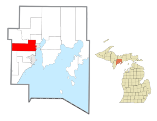
The Hannahville Indian Community is a federally recognized Potawatomi tribe residing in Michigan's Upper Peninsula, approximately 15 miles (24 km) west of Escanaba on a 8.5755-square-mile (22.210 km2) reservation. The reservation, at 45°46′59″N87°25′23″W, lies mostly in Harris Township in eastern Menominee County, but a small part is located in northeastern Gourley Township, also in Menominee County, and another in Bark River Township in adjacent southwestern Delta County.

References

Notes

  1. 1 2 "2022 U.S. Gazetteer Files: Michigan". United States Census Bureau. Retrieved September 28, 2023.
  2. 1 2 3 "P1. Race – Cedarville township, Michigan: 2020 DEC Redistricting Data (PL 94-171)". U.S. Census Bureau. Retrieved September 28, 2023.
  3. 1 2 "U.S. Census website". United States Census Bureau . Retrieved January 31, 2008.
  4. U.S. Geological Survey Geographic Names Information System: Cedarville Township, Michigan
  5. Romig 1986, p. 230.
  6. 1 2 Romig 1986, p. 105.
  7. U.S. Geological Survey Geographic Names Information System: Cedar River, Michigan

Sources