"Population and Housing Census" redirects here. For the article about censuses in general, see Census.
The Botswana Population and Housing Census is a decennial census which is the once-a-decade population and housing count of all people in Botswana. This census is carried out by the Statistics Botswana (formerly Central Statistics Office).
The most recent census took place in 2022; the next census is scheduled for 2031. Through the census, Botswana systematically obtains/records information on demographic, social and economic characteristics, pertaining to all persons in the geographic boundaries of the country at a specified time. The Population and Housing Census aims to count all persons, vis. citizens, non-citizens, visitors, babies, elderly, etc. living in Botswana and determine the socio-economic and demographic characteristics of the population. Such characteristics include among others, the total number, geographic distribution by sex, age, migration patterns, education, housing characteristics, household sizes, etc. Therefore, the census covers all inhabitants in Botswana.[1] The results of the census provide the Government and other stakeholders with relevant, reliable and timely baseline data and statistical information for development planning,[2] policy formulation and service delivery as well as for monitoring and evaluation of development programs and plans.
Census is a project that is provided for in the Census Act of 1904[1] and Statistics Act of 2009.[3] The population and housing census is a national exercise and it is implemented by the District Commissioners in their respective districts. Statistics Botswana, being the National Statistical Office is entrusted with the responsibility to coordinate the project. The Statistician General (SG) is the Principal Investigator responsible to Government for the conduct of the census while the District Commissioners (DCs) are the District Census Coordinators in the respective districts.[3]
Geographic divisions
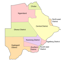
Botswana is made up of 10 administrative districts plus the two cities of Francistown and Gaborone. For census purposes, there are 28 census districts, which consist of; two
Districts of Botswana
(2) cities, five (5) towns, 17 sub districts and four (4) districts with no sub-district.
Confidentiality
The Census Act and Statistics Act strictly stipulates the protection and confidentiality of individual's data obtained during the census. The law goes further to spell out penalties for those (census officials and members of the public) who violate it.
The seven censuses of Botswana before its independence happened irregularly. Due to the Anglo-Boer War, the first census of Bechuanaland Protectorate, originally set to occur in 1901, took place on 17 April 1904.[4] The 1931 census was postponed to 1936 because of the Great Depression.[4] The early censuses were unreliable and took several years to tabulate; the results were outdated by the time they were calculated.
Post-independence
There have been six censuses after the independence of Botswana, each occurring every ten years in the year ending in 1 (i.e. 1971, 1981, 1991, 2001, 2011, and 2022). The 1971 census was the first census in Botswana to use de facto enumeration; this method counts people based on how many people spent census night at a specific location. Previously, the citizens were counted based on their usual place of residence. The 2001 census was the first census in Botswana to comply with the SADC 2000 Census Project, the guidelines of which unify the demographic statistics in southern Africa. The most recent census was the 2022 Botswana Population and Housing Census, which occurred in April 2022.[7]
Demographic features of the population of Botswana include population density, ethnicity, education level, health of the populace, economic status, religious affiliations and other aspects.
Gaborone is the capital and largest city of Botswana with a population of 246,325 based on the 2022 census, about 10% of the total population of Botswana. Its agglomeration is home to 421,907 inhabitants at the 2011 census.
Pine Valley was a borough in Camden County, in the U.S. state of New Jersey. As of the 2020 United States census, the borough's population was 21, an increase of 9 (+75.0%) from the 2010 census count of 12, which in turn reflected a decline of 8 (-40.0%) from the 20 counted in the 2000 census. As of the 2020 Census, Pine Valley was the third-smallest municipality by population in New Jersey, with 12 more residents than the nine residing in Tavistock and 14 more than the seven in Walpack Township.
Harvey Cedars is a coastal borough situated on the Jersey Shore, in southern Ocean County, in the U.S. state of New Jersey. The borough encompasses a narrow strip of Long Beach Island fronting both the Atlantic Ocean and Barnegat Bay. As of the 2020 United States census, the borough's population was 391, its highest decennial count ever and an increase of 54 (+16.0%) from the 2010 census count of 337, which in turn reflected a decline of 22 (−6.1%) from the 359 counted in the 2000 census.
Long Beach Township is a Walsh Act Township situated on the Jersey Shore, in southeastern Ocean County, in the U.S. state of New Jersey. As of the 2020 United States census, the township's population was 3,153, an increase of 102 (+3.3%) from the 2010 census count of 3,051, which in turn reflected a decline of 278 (−8.4%) from the 3,329 counted in the 2000 census.
Palapye is a growing town in Botswana, situated about halfway between Francistown and Gaborone. Over the years its position has made it a convenient stopover on one of Southern Africa's principal north–south rail and road routes.
Southern is one of the districts of Botswana. The capital of Southern district is Kanye, home to the Bangwaketse and Barolong in Botswana. The Southern district is home to Botswana's second largest beef farmers where there are large privately owned ranges, and several government run beef ranges which provide agricultural support to the local farmers. Maize and sorghum, Botswana's staple crop, are also raised in the area. Southern district is where the third diamond mine of Botswana was found, which buoys Botswana's economic state of prosperity. It was the first district to house the capital city before being moved to Gaborone after independence.
South-East is one of the districts of Botswana. The capital city of Botswana, Gaborone, is surrounded by this district. The administrative capital for the South-East district is the village of Ramotswa. In the southeast, South-East borders the North West Province of South Africa. Domestically, it borders Kgatleng in northeast, Kweneng in northwest, Southern in southwest.
The Gaborone City Council is the governing body of the city of Gaborone, Botswana. In terms of generated revenue, it is the wealthiest council in Botswana. It is composed of 30 councillors representing the wards of Gaborone.
Nepali'Nepali: नेपाली) are the citizens of Nepal under the provisions of Nepali nationality law. The term Nepali usually refers to the nationality, that is, to people with citizenship of Nepal, while the people without Nepali citizenship but with roots in Nepal such as [Nepali Americans]] are strictly referred to as Nepali Speaking Foreigners who are speakers of Nepali, Maithili or any of the other 128 NepaleseNepali languages but are now foreign citizens or of foreign nationality bearing passports and citizenship of the foreign nation. It is also not generally used to refer to non-citizen residents, dual citizens, and expatriates.
Otse is a village in the South-East District of Botswana. It is located 60 km south of Gaborone, along the Gaborone–Lobatse road and close to the border with South Africa. This village is home to the Balete people who are related to those in Ramotswa, Gabane and Mogobane. The population was 7,636 in 2011 census.
Christianity is the largest religion in Botswana. However, the country is officially secular and allows freedom of religious practice.
A census of the population of the United Kingdom is taken every ten years. The 2011 census was held in all counties of the UK on 27 March 2011. It was the first UK census which could be completed online via the Internet. The Office for National Statistics (ONS) is responsible for the census in England and Wales, the General Register Office for Scotland (GROS) is responsible for the census in Scotland, and the Northern Ireland Statistics and Research Agency (NISRA) is responsible for the census in Northern Ireland.
The history of Gaborone began with archaeological evidence in the area around Gaborone dating back to 400 BCE, and the first written accounts of Gaborone are from the earliest European settlers in the 19th century. Since the 1960s, when Botswana gained its independence from Britain and Gaborone became the capital, the city has grown from a small village in the Botswana scrubland to a major center in southern Africa.
The 2011 Botswana population and housing census was the latest national census of Botswana. The enumeration was managed by the Statistics Botswana and took place over ten days starting on 22 August 2011. The census counted a total population of 2,024,787, a 20.5% increase from the 2001 census.
This is a list of national population and housing censuses.
Statistics Botswana (StatsBots) is the National statistical bureau of Botswana. The organization was previously under the Ministry of Finance and development planning as a department and was called Central Statistics Office. The organisation was initially set up in 1967 through an Act of Parliament – the Statistics Act and thereafter transformed into a parastatal through the revised Statistics Act of 2009. This act gives the Statistics Botswana the mandate and authority to collect, process, compile, analyse, publish, disseminate and archive official national statistics. It is also responsible for "coordinating, monitoring and supervising the National Statistical System" in Botswana. The office has its main offices in Gaborone and three satellite offices in Maun, Francistown and Ghanzi. The different areas in statistics that should be collected are covered under this Act and are clearly specified. The other statistics that are not specified can be collected as long as they are required by the Government, stakeholders and the users.
This page is based on this Wikipedia article Text is available under the CC BY-SA 4.0 license; additional terms may apply. Images, videos and audio are available under their respective licenses.