Centerville, Indiana

Last updated

Centerville, Indiana
Centerville, Indiana.jpg
Wayne County Indiana Incorporated and Unincorporated areas Centerville Highlighted 1811836.svg
Location of Centerville in Wayne County, Indiana.
Coordinates: 39°49′31″N85°00′03″W / 39.82528°N 85.00083°W / 39.82528; -85.00083
Country United States
State Indiana
County Wayne
Township Center
Platted1814
Area
[1]
  Total3.54 sq mi (9.17 km2)
  Land3.52 sq mi (9.11 km2)
  Water0.02 sq mi (0.06 km2)
Elevation
[2]
1,020 ft (310 m)
Population
 (2020)
  Total2,748
  Density781.13/sq mi (301.60/km2)
Time zone UTC-5 (Eastern)
  Summer (DST) UTC-5 (EDT)
ZIP code
47330
Area code 765
FIPS code 18-11836 [3]
GNIS feature ID2396637 [2]
Website http://www.town.centerville.in.us/

Centerville is a town in Center Township, Wayne County, in the U.S. state of Indiana. [2] The population was 2,552 at the 2010 United States Census.

Contents

Geography

U.S. Route 40 runs east−west through town along Main Street.

According to the 2010 census, Centerville has a total area of 2.4 square miles (6.22 km2), all land. [4]

Centerville, looking east toward Richmond Centerville-indiana-from-above.jpg
Centerville, looking east toward Richmond

Demographics

Historical population
CensusPop.Note
1850 920
1860 9604.3%
1870 1,07712.2%
1880 875−18.8%
1890 864−1.3%
1900 785−9.1%
1910 1,01929.8%
1920 917−10.0%
1930 9938.3%
1940 1,16217.0%
1950 1,38619.3%
1960 2,37871.6%
1970 2,3800.1%
1980 2,284−4.0%
1990 2,3985.0%
2000 2,4271.2%
2010 2,5525.2%
2020 2,7487.7%
US Decennial Census [5]

2010 census

As of the 2010 United States Census, [6] there were 2,552 people, 1,038 households, and 738 families in the town. The population density was 1,063.3 inhabitants per square mile (410.5/km2). There were 1,147 housing units at an average density of 477.9 per square mile (184.5/km2). The racial makeup of the town was 96.1% White, 0.6% African American, 0.1% Native American, 0.6% Asian, 1.3% from other races, and 1.2% from two or more races. Hispanic or Latino of any race were 2.5% of the population.

There were 1,038 households, of which 37.8% had children under the age of 18 living with them, 49.6% were married couples living together, 17.1% had a female householder with no husband present, 4.4% had a male householder with no wife present, and 28.9% were non-families. 26.1% of all households were made up of individuals, and 9.9% had someone living alone who was 65 years of age or older. The average household size was 2.46 and the average family size was 2.95.

The median age in the town was 37.1 years. 27.4% of residents were under the age of 18; 7.3% were between the ages of 18 and 24; 26.8% were from 25 to 44; 24.9% were from 45 to 64; and 13.5% were 65 years of age or older. The gender makeup of the town was 47.5% male and 52.5% female.

2000 census

As of the 2000 United States Census, [3] there were 2,427 people, 944 households, and 676 families in the town. The population density was 2,421.5 inhabitants per square mile (934.9/km2). There were 1,001 housing units at an average density of 998.7 per square mile 998.7 per square mile (385.6/km2). The racial makeup of the town was 98.48% White, 0.21% African American, 0.04% Native American, 0.29% Asian, 0.74% from other races, and 0.25% from two or more races. Hispanic or Latino of any race were 1.07% of the population.

There were 944 households, out of which 36.7% had children under the age of 18 living with them, 52.8% were married couples living together, 15.6% had a female householder with no husband present, and 28.3% were non-families. 26.2% of all households were made up of individuals, and 11.1% had someone living alone who was 65 years of age or older. The average household size was 2.46 and the average family size was 2.95.

The town population contained 27.3% under the age of 18, 7.5% from 18 to 24, 28.8% from 25 to 44, 18.9% from 45 to 64, and 17.6% who were 65 years of age or older. The median age was 36 years. For every 100 females, there were 84.0 males. For every 100 females age 18 and over, there were 77.7 males.

The median income for a household in the town was $32,219, and the median income for a family was $37,566. Males had a median income of $31,875 versus $22,450 for females. The per capita income for the town was $15,526. About 5.3% of families and 6.7% of the population were below the poverty line, including 9.7% of those under age 18 and 3.5% of those age 65 or over.

History

Centerville was platted in 1814 on land bought from the Miami Indians at the Twelve Mile Purchase. It was settled by Quakers originally from Centreville, Delaware. Centre Monthly Meeting in Delaware is part of Baltimore Yearly Meeting of the Society of Friends, whose Indian relations office first sent a delegation of Quakers to Indiana Territory at the request of Chief Little Turtle of the Miami Indians, who visited them in Baltimore. Friends from Delaware lived for a time in Guilford County, North Carolina before permanently moving to Indiana Territory when it opened for settlement. The community is said to be named for its location near the middle of the county, but it’s not in the center. [7] A little-known county seat war was fought in Wayne County in 1873 between Centerville and Richmond. The county seat had been located in Centerville (Center Township) since 1818. [8] By 1870, Richmond (Wayne Township) had surpassed Centerville in business, population, and tax revenue. These factors led the population of Wayne Township to demand the county seat be moved to Richmond. The dispute was played out in the newspapers, courts, and petitions, with Richmond the eventual winner. A new courthouse was erected in Richmond and preparations were made to move records from Centerville to Richmond. Centerville residents twice stopped Richmond's officials’ efforts to move the records, first with guarded locked gates, then by firing on their own courthouse with a three-pound cannon nicknamed “Black Betty.” The cannon was used when Richmond guards were brought in to protect the records. The cannon had been loaded with iron scraps. A crowd demanded the guard come out of the Centerville courthouse. When they refused, the cannon was fired, the door blown off its hinges, and the guards were forced to beat a hasty retreat. [9] Soldiers were brought in the next day to move the records to Richmond. Centerville's tenure as county seat had come to an end. The holes from the cannon shot are still visible over the door of the old courthouse, now the Center Township Library.

Center Township Library, showing cannonade marks Center Township Library.jpg
Center Township Library, showing cannonade marks

The Centerville post office has been in operation since 1818. [10]

In 1828 the National Road, which ran along Centerville's Main Street, was surveyed. It later became the first improved section of the trail in 1850 by a Special Act of Congress.

Centerville's cobblestone street was a major stop along the trail to the West. During the height of the Gold Rush, 49,000 wagons would travel along the street each year.

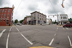
Centerville is known as the “City of Arches” due to the five main arches on the Old National Road. The original road was 100 feet (30.5 m) wide, but was reduced to 65 feet (19.8 m) after several buildings in the town had encroached into the roadway. The arches were used as a way to get behind the buildings and into the backyards of the houses. [11] The five arches in Centerville are the Backenstoes, Dill, Shortridge, Lantz, and Malone Archways, all built between 1823 and 1836. [12] In August, Centerville has Archway Days, held to celebrate the historical archways.

The Centerville Historic District (Centerville, Indiana), Oliver P. Morton House, and Westcott Stock Farm are listed on the National Register of Historic Places. [13]

Education

Centerville has one secondary school, Centerville Senior High School, and one library, Centerville-Center Township Public Library. [14]

Notable people

Related Research Articles

<span class="mw-page-title-main">Appanoose County, Iowa</span> County in Iowa, United States

Appanoose County is a county in the U.S. state of Iowa. As of the 2020 census, the population was 12,317. Its county seat is Centerville.

<span class="mw-page-title-main">Wayne County, Indiana</span> County in Indiana, United States

Wayne County is a county located in east central Indiana, United States, on the border with Ohio. As of the 2020 United States Census, the population was 66,553. The county seat is Richmond. Wayne County comprises the Richmond, IN Micropolitan Statistical Area. Richmond hosts Earlham College, a small private liberal arts college.

<span class="mw-page-title-main">Monroeville, Indiana</span> Town in Indiana, United States

Monroeville is a town in Monroe Township, Allen County, Indiana, United States. The population was 1,294 as of the 2020 census.

<span class="mw-page-title-main">Nashville, Indiana</span> Town in Indiana, United States

Nashville is a town in Washington Township, Brown County, Indiana, United States. The population was 803 at the 2010 census. The town is the county seat of Brown County and is the county's only incorporated town. The town is best known as the center of the Brown County Art Colony and as a tourist destination.

<span class="mw-page-title-main">Chesterfield, Indiana</span> Town in Indiana, United States

Chesterfield is a town in the U.S. state of Indiana which lies in Union Township, Madison County, and Salem Township, Delaware County. The population was 2,490 at the 2020 census. It is part of the Indianapolis–Carmel–Anderson metropolitan statistical area.

<span class="mw-page-title-main">Leesburg, Indiana</span> Town in Indiana, United States

Leesburg is a town in Plain Township, Kosciusko County, in the U.S. state of Indiana. The population was 555 at the 2010 Census. The town of Leesburg was laid out in 1833 by Levi Lee. It includes the Leesburg Historic District.

<span class="mw-page-title-main">LaGrange, Indiana</span> Town in Indiana, United States

LaGrange is a town in and the county seat of LaGrange County, Indiana, United States. The population was 2,625 at the 2010 census.

<span class="mw-page-title-main">Wolcottville, Indiana</span> Town in Indiana, United States

Wolcottville is a town in Orange Township, Noble County and Johnson Township, LaGrange County in the U.S. state of Indiana. The population was 998 at the 2010 census.

New Richmond is a town in Coal Creek Township, Montgomery County, in the U.S. state of Indiana. The population was 309 at the 2020 census.

<span class="mw-page-title-main">Modoc, Indiana</span> Town in Indiana, United States

Modoc is a town in Union Township, Randolph County, in the U.S. state of Indiana. The population was 196 at the 2010 census.

<span class="mw-page-title-main">Rushville, Indiana</span> City in Indiana, United States

Rushville is a city in Rushville Township, Rush County, in the U.S. state of Indiana. The population was 6,185 at the 2020 census. The city is the county seat of Rush County. It, like the county, was named in honor of Dr. Benjamin Rush, who signed the Declaration of Independence.

<span class="mw-page-title-main">Boston, Indiana</span> Town in Indiana, United States

Boston is a town in Boston Township, Wayne County, Indiana, United States. The population was 138 at the 2010 census.

<span class="mw-page-title-main">East Germantown, Indiana</span> Town in Indiana, United States

East Germantown is a town in Jackson Township, Wayne County, in the U.S. state of Indiana. The population was 410 at the 2010 census.

<span class="mw-page-title-main">Economy, Indiana</span> Town in Indiana, United States

Economy is a town in Perry Township, Wayne County, in the U.S. state of Indiana. The population was 173 at the 2021 census.

<span class="mw-page-title-main">Fountain City, Indiana</span> Town in Indiana, United States

Fountain City, formerly Newport, is a town in New Garden Township, Wayne County, in the U.S. state of Indiana. The population was 796 at the 2010 census.

<span class="mw-page-title-main">Greens Fork, Indiana</span> Town in Indiana, United States

Greens Fork is a town in Clay Township, Wayne County, in the U.S. state of Indiana. The population was 423 at the 2010 census.

<span class="mw-page-title-main">Whitewater, Indiana</span> Town in Indiana, United States

Whitewater is a town in Franklin Township, Wayne County, in the U.S. state of Indiana. The population was 83 at the 2010 census.

<span class="mw-page-title-main">Centerville Township, Michigan</span> Civil township in Michigan, United States

Centerville Township is a civil township of Leelanau County in the U.S. state of Michigan. The population was 1,243 at the 2020 census. The township is bounded to the east by Lake Leelanau.

<span class="mw-page-title-main">Centerville, Washington County, Pennsylvania</span> Borough in Washington County, Pennsylvania, United States

Centerville is a borough in Washington County, Pennsylvania, United States. The population was 3,254 at the 2020 census.

<span class="mw-page-title-main">Hagerstown, Indiana</span> Town in Indiana, United States

Hagerstown is a town in Jefferson Township, Wayne County, in the U.S. state of Indiana. As of the 2020 census, the population was 1,681.

References

  1. "2020 U.S. Gazetteer Files". United States Census Bureau. Retrieved March 16, 2022.
  2. 1 2 3 U.S. Geological Survey Geographic Names Information System: Centerville, Indiana
  3. 1 2 "US Census website". US Census Bureau . Retrieved January 31, 2008.
  4. "Geographic Identifiers - 2010 Census Summary File 1". US Census Bureau. Archived from the original on February 13, 2020. Retrieved July 13, 2015.
  5. "Census of Population and Housing". Census.gov. Retrieved June 4, 2015.
  6. "US Census website". US Census Bureau . Retrieved December 11, 2012.
  7. "Profile for Centerville, IN". ePodunk . Retrieved July 7, 2016.
  8. "History of Richmond & Wayne County, Indiana". WayNet. Retrieved June 2, 2014.
  9. Spahr, W. E. (1966). "Center Township Library, Centerville, Indiana".>(Waynet.org, accessed 18 July 2010)
  10. "Wayne County". Jim Forte Postal History. Archived from the original on September 14, 2005. Retrieved July 7, 2016.
  11. "Centerville, Indiana: The city of arches". "Centerville, Indiana. The City of Arches". March 10, 2008. Archived from the original on July 15, 2011. Retrieved July 22, 2010. Retrieved from The Lantz House and Gathering Place Inn.
  12. Centerville, Indiana (Waynet: Community Network Association (accessed 16 July 2010)
  13. "National Register Information System". National Register of Historic Places . National Park Service. July 9, 2010.
  14. "Indiana public library directory" (PDF). Indiana State Library. Archived from the original (PDF) on February 18, 2017. Retrieved March 15, 2018.