Central Deccan Plateau dry deciduous forests

Last updated

Central Deccan Plateau dry deciduous forests
Nallamalla forests at Srisailam.jpg
Nallamalla forests at Srisailam
Ecoregion IM0201.png
Ecoregion territory (in purple)
Ecology
Realm Indomalayan
Biome tropical and subtropical dry broadleaf forests
Borders
Geography
Area239,376 km2 (92,424 sq mi)
Country India
States
Conservation
Conservation status critical/endangered
Protected9,742 km² (4%) [1]

The Central Deccan Plateau dry deciduous forests in Western and Southern India, containing large protected areas of natural tiger habitat.

Contents

Distribution

The Deccan Plateau is a large triangular plateau in southern India, bounded by the Western Ghats range to the west, the Eastern Ghats to the east, and the western Satpura Range to the north. The Central Deccan Plateau dry deciduous forests occupy an area of 240,200 square kilometers (92,700 sq mi), in which the dominant natural habitat is or was woodland of Hardwickia binata and Albizia amara trees, located on the central and southern portion of the plateau. The ecoregion lies mostly within the states of Maharashtra and Telangana, extending into adjacent parts of Madhya Pradesh, Chhattisgarh, and Andhra Pradesh. In Maharashtra, the Central Deccan Plateau dry deciduous forests cover most of the Vidarbha region, including the city of Nagpur. In Telangana, the dry deciduous forests cover much of the state, including Hyderabad, the state capital, with a small portion extending across the Eastern Ghats to the Bay of Bengal in Krishna District of Andhra Pradesh. [2]

Typically the plateau extends from the Konkan Deccan divide north of Pune to the Krishna river in Telangana. Majority of the geology of the region is of Basaltic rocks which harbor a very different drainage pattern and different forest cover with an average mature tree height of over 10 metres (33 ft), while the granitoid region that is primarily affluent across Telangana and parts of Karnataka covers scrub jungle with an average tree height of around 5 metres (16 ft). A small part of Nallamala hill range that encompass the Amrabad Tiger Reserve and Srisailam Tiger Reserves are sedimentary rock scapes with dry thick vegetation and added to the ecoregion. All three forests have many uniquely different landscapes, easily visible, within this unique ecoregion. For example in the granitoid region, tigers, jackals, wild dogs and wolves are all extinct, while the peninsular rock agama is only found here.

The xeric Deccan thorn scrub forests lie to the west, south, and southeast, covering the drier portions of the plateau in the rain shadow of the Western Ghats. The more humid Eastern Highlands moist deciduous forests lie to the northeast and east, while the Narmada Valley dry deciduous forests lie across the Satpuras to the northwest.

The Godavari River crosses the ecoregion from its source in the Western Ghats and indeed most of the rivers on the plateau drain east towards the Bay of Bengal, with the exception of the Tapti River in the northwestern corner of the plateau, which drains westward into the Arabian Sea.

This is a highly populated area and most of the natural forest in the ecoregion has been cleared for firewood or grazing land or as a result of river damming, all of which are ongoing. However large blocks of original habitat such as the Nagarjunsagar-Srisailam Tiger Reserve in Telangana and Andhra Pradesh do remain.

Flora

Woodlands of Hardwickia binata and Albizia amara are the characteristic plant community of this ecoregion, distinguishing it from the predominantly teak ( Tectona grandis ) or sal ( Shorea robusta ) woodlands found elsewhere in the Deccan. The Central Deccan forests have an upper canopy at 15–25 metres (49–82 ft), and an understory at 10–15 metres (33–49 ft), with little undergrowth. [3] The Hardwickia trees lose their leaves during the winter dry season, and leaf out again in April. [4]

Other tree species in the northern part of the ecoregion include: [3]

Fauna

Bengal tiger at the Tadoba Andhari Tiger Reserve Bengal Tiger Panthera tigris tigris by Raju Kasambe DSCN3882 04.jpg
Bengal tiger at the Tadoba Andhari Tiger Reserve

The large areas of remaining forest on the plateau are still home to a variety of grazing animals from the four-horned antelope (Tetracerus quadricornis), chinkara (Gazella bennettii), and blackbuck (Antilope cervicapra) to the large gaur and wild water buffalo (Bubalus arnee).

Large carnivores include:

The area is home to nearly ninety mammal species. Some of the larger species mentioned above are rare, as is the threatened Indian giant squirrel (Ratufa indica). The 300 species of birds include the globally threatened Jerdon's courser (Rhinoptilus bitorquatus), which was rediscovered in 1986 having been thought extinct for nearly a hundred years. Other birds include bush quails (genus Perdicula), white-browed fantail and painted spurfowl.

Conservation

About 80 percent of the natural habitat in the ecoregion has been lost. Several blocks of habitat larger than 5,000 square kilometres (1,900 sq mi) remain. Fifteen protected areas cover almost three percent of the ecoregion's area, with Nagarjunsagar-Srisailam Tiger Reserve the largest. [3]

Protected areas within the dry deciduous forest ecoregion of the Central Deccan Plateau
NameArea in km2 (sq mi)District(s)State(s)
Bor Wildlife Sanctuary 80 (31) Wardha Maharashtra
Chaprala Wildlife Sanctuary 130 (50) Gadchiroli
Gautala Autramghat Sanctuary 260 (100) Aurangabad; Jalgaon
Katepurna Wildlife Sanctuary 420 (160) Akola
Nagzira Wildlife Sanctuary 150 (58)Bhandara; Gondia
Navegaon National Park 170 (66) Gondia
Painganga Wildlife Sanctuary 130 (50) Yavatmal
Pench National Park 440 (170) Seoni; Chhindwara Madhya Pradesh
Gundla Brahmeswaram Wildlife Sanctuary 120 (46) Kurnool; Prakasam Andhra Pradesh
Kolleru Wildlife Sanctuary [lower-alpha 1] 220 (85)
Kawal Tiger Reserve 160 (62) Komaram Bheem Asifabad Telangana
Manjira Wildlife Sanctuary 30 (12) Medak district
Pocharam Wildlife Sanctuary 120 (46) Medak district
Nagarjunsagar-Srisailam Tiger Reserve 3,721 (1,437) [lower-alpha 2] Telangana
Andhra Pradesh
  1. Lies partly in the Eastern Highlands moist deciduous forests ecoregion
  2. There is an additional muti-use buffer zone of 2,216 km2 (856 sq mi), giving an overall land area for the reserve of 5,837 km2 (2,254 sq mi). [5]

See also

Related Research Articles

<span class="mw-page-title-main">Deccan Plateau</span> Plateau in southern India

The large Deccan Plateau of the Indian Subcontinent is located between the Western Ghats and the Eastern Ghats, and is loosely defined as the peninsular region between these ranges that is south of the Narmada river. To the north, it is bounded by the Satpura and Vindhya Ranges.

<span class="mw-page-title-main">Satpura Range</span> Hill range in central India

The Satpura Range is a range of hills in central India. The range rises in eastern Gujarat running east through the border of Maharashtra and Madhya Pradesh and ends in Chhattisgarh. The range parallels the Vindhya Range to the north, and these two east–west ranges divide Indian Subcontinent into the Indo-Gangetic plain of northern India and the Deccan Plateau of the south. The Narmada River originates from north-eastern end of Satpura in Amarkantak, and runs in the depression between the Satpura and Vindhya ranges, draining the northern slope of the Satpura range, running west towards the Arabian Sea. The Tapti River originates in the eastern-central part of Satpura, crossing the range in the center and running west at the range's southern slopes before meeting the Arabian Sea at Surat, draining the central and southern slopes of the range. Multai, the place of Tapi river origin is located about 465 kilometer far, south-westerly to Amarkantak, separated across by the hill range. The Godavari River and its tributaries drain the Deccan plateau, which lies south of the range, and the Mahanadi River drains the easternmost portion of the range. The Godavari and Mahanadi rivers flow into the Bay of Bengal. At its eastern end, the Satpura range meets the hills of the Chotanagpur Plateau. The Satpura Range is a horst mountain and is flanked by Narmada Graben in the north and much smaller but parallel Tapi Graben in the south.

<span class="mw-page-title-main">Chota Nagpur Plateau</span> Plateau of India

The Chota Nagpur Plateau is a plateau in eastern India, which covers much of Jharkhand state as well as adjacent parts of Chhattisgarh, Odisha, West Bengal and Bihar. The Indo-Gangetic plain lies to the north and east of the plateau, and the basin of the Mahanadi river lies to the south. The total area of the Chota Nagpur Plateau is approximately 65,000 square kilometres (25,000 sq mi).

<span class="mw-page-title-main">East Deccan dry evergreen forests</span> Ecoregion of India

The East Deccan dry evergreen forests is an ecoregion of southeastern India. The ecoregion includes the coastal region behind the Coromandel Coast on the Bay of Bengal, between the Eastern Ghats and the sea. It covers eastern Tamil Nadu, part of Puducherry and south eastern Andhra Pradesh.

<span class="mw-page-title-main">Malabar Coast moist forests</span> Ecoregion in India

The Malabar Coast moist forests are a tropical moist broadleaf forest ecoregion of southwestern India.

<span class="mw-page-title-main">North Western Ghats moist deciduous forests</span> Ecoregion in India

The North Western Ghats moist deciduous forests is a tropical moist broadleaf forest ecoregion of southwestern India.

<span class="mw-page-title-main">South Western Ghats moist deciduous forests</span> Ecoregion in India

The South Western Ghats moist deciduous forests is an ecoregion in the Western Ghats of southern India with tropical and subtropical moist broadleaf forests. This biome covers the Nilgiri Hills between elevation of 250 and 1,000 m in Kerala, Karnataka and Tamil Nadu states.

<span class="mw-page-title-main">South Deccan Plateau dry deciduous forests</span> Ecoregion in India

The South Deccan Plateau dry deciduous forests is a tropical dry forest ecoregion in southern India. The ecoregion lies in the southernmost portion of the Deccan Plateau, and includes the southernmost portion of the Eastern Ghats.

<span class="mw-page-title-main">Biligiriranga Hills</span> Wildlife sanctuary in South India

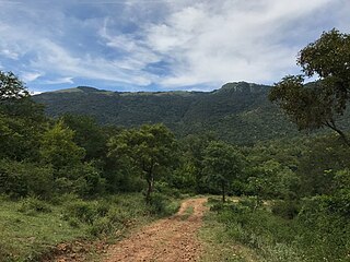
The Biligirirangana Hills or Biligirirangan Hills is a hill range situated in south-western Karnataka, at its border with Tamil Nadu in South India. The area is called Biligiri Ranganatha Swamy Temple Wildlife Sanctuary or simply BRT Wildlife Sanctuary. It is a protected reserve under the Wildlife Protection Act of 1972. Being close to the Eastern Ghats as well as the Western Ghats, the sanctuary has floral and faunal associations with both regions. The site was declared a tiger reserve in January 2011 by the Government of Karnataka, a few months after approval from India's National Tiger Conservation Authority.

<span class="mw-page-title-main">Eastern Highlands moist deciduous forests</span> Ecoregion of India

The Eastern Highlands moist deciduous forests, presently known as East Deccan moist deciduous forests, is a tropical and subtropical moist broadleaf forests ecoregion in east-central India. The ecoregion covers an area of 341,100 square kilometers (131,700 sq mi), extending across portions of Andhra Pradesh, Chhattisgarh, Jharkhand, Madhya Pradesh, Maharashtra, Odisha, and Telangana states.

<span class="mw-page-title-main">Northern dry deciduous forests</span> Ecoregion of India

The Northern dry deciduous forests, presently known as the North Deccan dry deciduous forests, is a tropical dry broadleaf forest ecoregion of east-central India.

The Mysore region is an unofficial region that is part of Karnataka state in southern India. It forms approximately the southern half of the non-coastal areas of that state. The area corresponds almost exactly to that of the erstwhile princely state of Mysore. Almost all of that principality, with the exception of a few areas that now lie in neighbouring states, is comprehended by this term.

<span class="mw-page-title-main">Narmada Valley dry deciduous forests</span> Ecoregion in India

The Narmada Valley dry deciduous forests are a tropical dry forest ecoregion of central India. The ecoregion lies mostly in Madhya Pradesh state, but extends into portions of Chhattisgarh, Maharashtra, Karnataka and Uttar Pradesh states.

<span class="mw-page-title-main">Deccan thorn scrub forests</span> Ecoregion of India and Sri Lanka

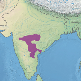
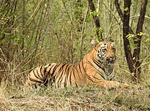
The Deccan thorn scrub forests are a xeric shrubland ecoregion of south India and northern Sri Lanka. Historically this area was covered by tropical dry deciduous forest, but this only remains in isolated fragments. The vegetation now consists of mainly of southern tropical thorn scrub type forests. These consist of open woodland with thorny trees with short trunks and low, branching crowns; spiny and xerophytic shrubs; and dry grassland. This is the habitat of the great Indian bustard and blackbuck, though these and other animals are declining in numbers; this area was at one time home to large numbers of elephants and tigers. Almost 350 species of bird have been recorded here. The remaining natural habitat is threatened by overgrazing and invasive weeds, but there are a number of small protected areas which provide a haven for the wildlife. Trees in these forests have adapted to not require much water.

<span class="mw-page-title-main">Bayalu Seeme</span>

Bayaluseeme or Bayalu Seeme is the area lying to the east of Malenadu, a region of Karnataka state in India. The area is largely open plain, with few hillocks. It includes the districts of Bangalore, Bagalkot, Bijapur, Chitradurga, Davanagere, Dharwad, Gadag, Hassan, Haveri, Mandya, Mysore, and Tumkur.

<span class="mw-page-title-main">Geography of South India</span> Overview of the geography of South India

The Geography of South India comprises the diverse topological and climatic patterns of South India. South India is a peninsula in the shape of a vast inverted triangle, bounded on the west by the Arabian Sea, on the east by the Bay of Bengal and on the north by the Vindhya and Satpura ranges.

Nagarjunsagar-Srisailam Tiger Reserve is the largest tiger reserve in India. The reserve spreads over five districts, Nandyal District, Prakasam District, Palnadu District, Nalgonda District and Mahabub Nagar district. The total area of the tiger reserve is 3,728 km2 (1,439 sq mi). The core area of this reserve is 1,200 km2 (460 sq mi). The reservoirs and temples of Srisailam are major attraction for many tourists and pilgrims. It is the largest tiger reserve forest in India and is located inside Nallamala forest area.

<span class="mw-page-title-main">Nallamala Hills</span> Mountain range in India

The Nallamalas are a section of the Eastern Ghats which forms the eastern boundary of Rayalaseema region of the state of Andhra Pradesh and Nagarkurnool district of the state of Telangana, in India. They run in a nearly north–south alignment, parallel to the Coromandel Coast for close to 430 km between the rivers, Krishna and Pennar. Its northern boundaries are marked by the flat Palnadu basin while in the south it merges with the Tirupati hills. An extremely old system, the hills have extensively weathered and eroded over the years. The average elevation today is about 520 m which reaches 1100 m at Bhairani Konda and 1048 m at Gundla Brahmeswara. Both of these peaks are in a north westerly direction from the town of Cumbum. There are also many other peaks above 800m.

<i>Albizia amara</i> Species of legume

Albizia amara is a tree in the family Fabaceae. Its range includes southern and Eastern Africa, from South Africa to Sudan and Ethiopia. It is also found in India and Sri Lanka.

<span class="mw-page-title-main">Nagarkurnool district</span> District of Telangana in India

Nagarkurnool district is a district in the southern region of the Indian state of Telangana. The town of Nagarkurnool is the district headquarters. It was part of the Mahbubnagar district prior to re-organisation of districts in the state. The district shares boundaries with Nalgonda, Rangareddy, Mahabubnagar, Wanaparthy districts and with the state boundary of Andhra Pradesh with Nandyal, Palnadu and Prakasam Districts.

References

  1. Dinerstein, Eric; Olson, David; Joshi, Anup; Vynne, Carly; Burgess, Neil D.; et al. (June 2017). "An Ecoregion-Based Approach to Protecting Half the Terrestrial Realm". BioScience. 67 (6): 534–545. doi:10.1093/biosci/bix014. PMC   5451287 .
  2. "Central Deccan Plateau dry deciduous forests". Terrestrial Ecoregions. World Wildlife Fund.
  3. 1 2 3 Wikramanayake, Eric; Eric Dinerstein; Colby J. Loucks; et al. (2002). Terrestrial Ecoregions of the Indo-Pacific: A Conservation Assessment. Island Press; Washington, DC. pp. 324-326
  4. "Hardwickia binata". Agroforestry Database 4.0, Orwa et al.2009. Accessed 18 July 2014
  5. National Tiger Conservation Authority: 'Project Tiger' (n.d.), Nagarjunasagar Srisailam Tiger Reserve briefing note (PDF), Government of India; Ministry of the Environment, Forests and Climate Change, archived from the original (PDF) on 2 May 2021

16°00′00″N79°00′00″E / 16.0000°N 79.0000°E / 16.0000; 79.0000