Sampang Regency is a regency of East Java province, Indonesia. It is situated on Madura Island, bordering on Pamekasan Regency to the east, the Java Sea to the north, Bangkalan Regency to the west, and Madura Strait to the south. It covers an area of 1,228.25 km2, and had a population of at the 2010 census 877,772 and at the 2020 census 969,694; the official estimate as of mid-2023 was 988,360 - comprising 488,900 males and 499,460 females. The administrative centre is the port of Sampang, on the south coast of Madura.

North Bengkulu is a regency of Bengkulu Province, Indonesia, on the island of Sumatra. It originally covered much of the northern part of Bengkulu Province, but on 25 February 2003 the most northwesterly districts were split off to form a separate Mukomuko Regency, and on 24 June 2008 the most southeastern districts were likewise split off to create a new Central Bengkulu Regency. The residual regency now covers an area of 4,424.59 km2, and it had a population of 257,675 at the 2010 Census and 296,523 at the 2020 Census; the official estimate as at mid 2022 was 302,833. The administrative centre is at the town of Arga Makmur.

South Aceh Regency is a regency in the Aceh province of Indonesia. It is located on the west coast of the island of Sumatra. The regency covers an area of 4,173.82 square kilometres and had a population of 202,251 at the 2010 Census, 224,588 in 2015 and 232,414 at the 2020 Census; the official estimate as at mid 2023 was 239,475 . Its population density was thus 48.5 inhabitants/km2 at the 2010 census, 53.8 inhabitants/km2 in 2015, 55.7 inhabitants/km2 at the 2020 census, and 57.4 inhabitants/km2 in mid 2023. The seat of the regency government is at Tapaktuan.

Langkat Regency is the northernmost regency of North Sumatra Province in Indonesia. Its administrative centre is the town of Stabat. It has a land area of 6,263.29 km2 and its population was 967,535 at the 2010 Census and 1,030,202 at the 2020 Census; the official estimate as at mid 2023 was 1,066,711 - comprising 538,822 males and 527,889 females.

Central Bangka Regency is a regency (kabupaten) of the Bangka Belitung Islands Province, Indonesia. It covers an area of 2,155.77 km2 and had a population of 161,075 at the 2010 Census, rising to 198,946 at the 2020 Census; the official estimate as at mid 2022 was 205,510 - comprising 106,340 males and 99,170 females. The town of Koba is its regency seat.

Mamberamo Raya Regency is one of the regencies (kabupaten) in Papua Province, Indonesia; it was created on 15 March 2007 from parts of Sarmi Regency and Waropen Regency. It covers an area of 23,813.91 km2, and had a population of 18,365 at the 2010 Census which had virtually doubled to 36,483 at the 2020 Census; the official estimate as at mid 2022 was 37,616. The administrative centre is at the town of Burmeso in Mamberamo Tengah District.
West Halmahera Regency is a regency in North Maluku Province of Indonesia. The regency was created on 25 February 2003 from the western districts of the former North Maluku Regency, and is now bounded by North Halmahera Regency to the north and east, while to the south it borders both East Halmahera Regency and that portion of the city of Tidore on the mainland of Halmahera. It covers an area of 2,239.11 km2, and it had a population of 100,424 people at the 2010 Census and 132,349 at the 2020 Census; the official estimate as at mid 2023 was 137,543. The capital lies at Jailolo (town).
South Halmahera Regency is a regency of North Maluku Province, Indonesia. It lies partly on Halmahera Island and partly on smaller islands to the west and south of Halmahera. It covers a land area of 8,779.32 km2, and at the 2010 Census it had a population of 198,911 people, while the 2020 Census showed that this had risen to 248,395 and the official estimate in mid 2023 was 255,384 The capital lies at the town of Labuha on Bacan Island.
East Halmahera Regency is a regency of North Maluku Province of Indonesia, and occupies the northeastern peninsula of Halmahera island, together with the northern half of the southeastern peninsula of that island. It was created on 25 February 2003 from part of Central Halmahera Regency, and covers a land area of 6,515.74 km2. It had a population of 72,880 at the 2010 Census and 91,707 at the 2020 Census; the official estimate as at mid 2023 was 97,895. The capital lies at the town of Maba in Kota Maba District.

Paser Regency is a regency (kabupaten) within East Kalimantan province in Indonesia, it is the southernmost regency of the East Kalimantan province. Its administrative centre is Tana Paser. It covers an area of 7,730 km2, and it had a population of 230,316 at the 2010 Census and 275,452 at the 2020 Census; the official estimate as at mid-2022 was 280,065 . Before 2007, this regency was formerly named Pasir Regency.

Meranti Islands is an archipelago forming a regency (kabupaten) of Riau Province and lies off the eastern coast of the island of Sumatra, Indonesia. It was created on 19 December 2008 by the separating of this archipelago from the mainland regency of Bengkalis. The regency comprises the islands of Tebing Tinggi, Rangsang, Padang, and Merbau, together with minor offshore islands, but does not include Bengkalis Island which is geographically part of the archipelago but remains within Bengkalis Regency. The principal town is Selat Panjang on Tebing Tinggi Island. The regency covers an area of 3,623.93 km2 and had a population of 176,290 at the 2010 Census and 206,116 at the 2020 Census; the official estimate as of mid-2022 was 213,532.

Kolaka Regency is a regency of Southeast Sulawesi Province, Indonesia. It covers an area of 2,958.69 km2 (1,142.36 sq mi) and had a population of 208,817 at the 2010 Census, rising to 237,587 at the 2020 Census; the official estimate as at mid 2022 was 246,137. The principal town lies at Kolaka.

South Konawe Regency is a regency of Southeast Sulawesi Province, Indonesia. It covers an area of 4,237.74 km2 and had a population of 264,587 at the 2010 Census and of 308,524 at the 2020 Census; the official estimate as at mid 2022 was 317,826 - comprising 162,949 males and 154,877 females. The administrative centre is in the town of Andoolo.
North Bolaang Mongondow Regency is a regency of North Sulawesi Province of Indonesia. It was created on 2 January 2007 by splitting off districts which were previously part of Bolaang Mongondow Regency. The regency covers an area of 1,672.61 km2 and had a population of 70,693 at the 2010 Census and 83,112 at the 2020 Census; the official estimate as at mid 2022 was 84,543. Bitauna is the only official town (kelurahan) in the regency, but the administrative centre is at Boroko.

Buru Regency is a regency of Maluku province, Indonesia. When it was first created on 4 October 1999, the regency encompassed the entire island ; but on 24 June 2008 the southern 40% of the island was split off to form a separate Buru Selatan Regency. The residual Buru Regency comprises the northern 60% of the island of Buru and covers an area of 7,595.58 km2. The population at the 2010 census was 108,445 and at the 2020 census this had increased to 135,238; the official estimate as at mid 2023 was 139,408. The principal town lies at Namlea.

Central Maluku Regency is a regency of Maluku Province of Indonesia. The Regency covers an area of 11,595.57 km2, and had a population of 361,698 at the 2010 Census, and 423,094 at the 2020 Census. The official estimate as at mid 2023 was 430,798. The principal town lies at Masohi, on Seram Island. The regency (kebupaten) is composed of the central part of the island of Seram, the Banda Islands, and the Lease Islands, together with those parts of Ambon Island which are outside the City of Ambon.

Southwest Maluku Regency is a regency of Maluku Province, Indonesia. Geographically it forms the most eastern portion of the Lesser Sunda Islands, although it has never been administratively included with them, and politically has always comprised a part of the Maluku Province. It comprises a number of islands and island groups in the south of the province, including Lirang Island, Wetar Island, Kisar Island, Romang Island, the Letti Islands, the Damer Islands, the Sermata Islands and the Babar Islands. The total land area is 4,581.06 km2, and the population was 70,714 at the 2010 Census and 81,928 at the 2020 Census; the official estimate as at mid 2023 was 93,766.
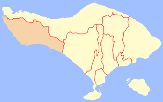
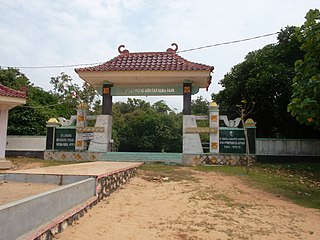
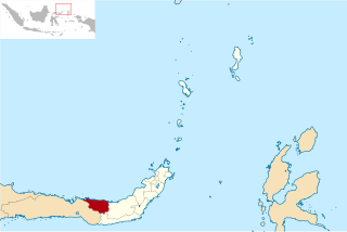
Jembrana Regency is a regency (kabupaten) in the southwest of Bali, Indonesia. It has an area of 841.8 km2 and had a population of 261,638 at the 2010 Census and 317,064 at the 2020 Census; the official estimate as at mid 2022 was 327,850. Its regency seat is the town of Negara.

Haruku Island is an island in Central Maluku Regency, Maluku Province, Indonesia - lying east of Ambon Island, off the southern coast of Seram and just west of Saparua. It is administered as a single district, Haruku Island District, with a land area of 150 km2 and a population of 24,207 at the 2010 census and 27,390 at the 2020 Census; the official estimate as at mid 2023 was 26,551. The inhabitants of Haruku speak the Haruku language, as well as Indonesian and Ambonese Malay.

The Lease Islands, formerly called the Uliasers or Uliassers, are a group of three inhabited islands, lying immediately to the south of Seram and east of Ambon Island in the province of Maluku, in Indonesia. The three inhabited islands, from west to east, are Haruku, Saparua and Nusa Laut, while tiny uninhabited Molana is administratively part of Saparua District; these islands constitute four administrative districts (kecamatan) within Central Maluku Regency.


