
The Bay of Fundy is a bay between the Canadian provinces of New Brunswick and Nova Scotia, with a small portion touching the U.S. state of Maine. It is an arm of the Gulf of Maine. Its tidal range is the highest in the world. The name is probably a corruption of the French word fendu, meaning 'split'.
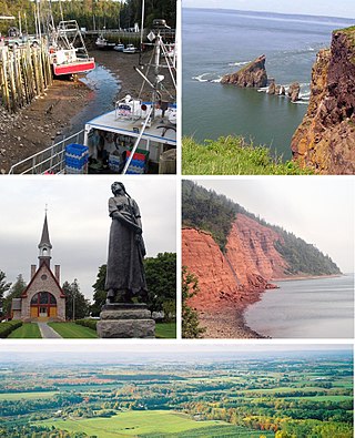
Kings County is a county in the Canadian province of Nova Scotia. With a population of 62,914 in the 2021 Census, Kings County is the third most populous county in the province. It is located in central Nova Scotia on the shore of the Bay of Fundy, with its northeastern part forming the western shore of the Minas Basin.

Canada has a large domestic and foreign tourism industry. The second largest country in the world, Canada's incredible geographical variety is a significant tourist attractor. Much of the country's tourism is centred in the following regions: Toronto, Montreal, Quebec City, Vancouver/Whistler, Niagara Falls, Vancouver Island, Canadian Rockies, British Columbia's Okanagan Valley, Churchill, Manitoba and the National Capital Region of Ottawa-Gatineau. The large cities are known for their culture, diversity, as well as the many national parks and historic sites.

Digby is an incorporated town in southwestern Nova Scotia, Canada. It is in the historical county of Digby and a separate municipality from the Municipality of the District of Digby. The town is situated on the western shore of the Annapolis Basin near the entrance to the Digby Gut, which connects the basin to the Bay of Fundy.

Advocate Harbour is a rural community located in Cumberland County, Nova Scotia, Canada.

Parrsboro is a community located in Cumberland County, Nova Scotia, Canada.

Joggins is a rural community located in western Cumberland County, Nova Scotia, Canada. On July 7, 2008 a 15-km length of the coast constituting the Joggins Fossil Cliffs was officially inscribed on the World Heritage List.

Grand-Pré National Historic Site is a park set aside to commemorate the Grand-Pré area of Nova Scotia as a centre of Acadian settlement from 1682 to 1755, and the British deportation of the Acadians that happened during the French and Indian War. The original village of Grand Pré extended four kilometres along the ridge between present-day Wolfville and Hortonville. Grand-Pré is listed as a World Heritage Site and is the main component of two National Historic Sites of Canada.
The Glooscap Trail is a scenic roadway in the Canadian province of Nova Scotia.
The Fundy Shore Ecotour is a former scenic drive and network of tourist destinations in the Canadian province of Nova Scotia and encircles several sub-basins of the Bay of Fundy, which contains the highest tidal range on the planet.

Nova Scotia is a province located in Eastern Canada fronting the Atlantic Ocean. One of the Maritime Provinces, Nova Scotia's geography is complex, despite its relatively small size in comparison to other Canadian provinces.

Long Island is a Canadian island in Digby County, Nova Scotia.

The Nova Scotia peninsula is a peninsula on the Atlantic coast of North America.

Cape Chignecto Provincial Park is a Canadian provincial park located in Nova Scotia. A wilderness park, it derives its name from Cape Chignecto, a prominent headland which divides the Bay of Fundy with Chignecto Bay to the north and the Minas Channel leading to the Minas Basin to the east. The park, which opened in 1998, is the largest provincial park in Nova Scotia. It also anchors one end of the UNESCO Cliffs of Fundy Global Geopark.

North Mountain is a narrow southwest-northeast trending volcanic ridge on the mainland portion of southwestern Nova Scotia, stretching from Brier Island to Cape Split. It forms the northern edge of the Annapolis Valley along the shore of the Bay of Fundy. Together with South Mountain, the two ranges form the Annapolis Highlands region.
Hall's Harbour is a fishing community in the Canadian province of Nova Scotia, located in Kings County on the North Mountain along the shore of the Bay of Fundy.
The Fundy Biosphere Region is located next to the upper Bay of Fundy, covering 442,250 hectares in New Brunswick, Canada. The area was named and designated as such by the United Nations Educational, Scientific and Cultural Organization (UNESCO) in 2007.
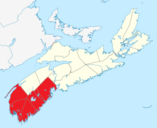
Southern Nova Scotia or the South Shore is a region of Nova Scotia, Canada. The area has no formal identity and is variously defined by geographic, county and other political boundaries. Statistics Canada, defines Southern Nova Scotia as an economic region, composed of Lunenburg County, Queens County, Shelburne County, Yarmouth County, and Digby County. According to Statistics Canada, the region had the highest decrease of population in Canada from 2009 to 2010, with a population decrease of 10.2 residents per thousand. The region also has the second-highest median age in Canada at 47.1 years old.

Cape d'Or is a headland located near Advocate, Cumberland County, on the Bay of Fundy coast of the Canadian province of Nova Scotia.
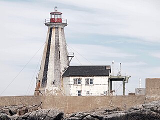
The Gannet Rock Lighthouse is a Canadian lighthouse located on a rocky islet 8 miles (13 km) south of Grand Manan in the Bay of Fundy. It was first lit in 1831 and was staffed until 1996. It was solarized in 2002 and remains operational in 2023. It was declared "surplus to requirements" by the Canadian Coast Guard in 2010 and is no longer being maintained.

