Cerro de la Estrella National Park

Last updated
Walking path in Cerro de la Estrella National Park. Cerro de la Estrella.jpg
Walking path in Cerro de la Estrella National Park.

Cerro de la Estrella National Park is centered on the Cerro de la Estrella mountain which is located entirely within eastern Mexico City, in the borough of Iztapalapa.

Contents

The park was originally designated in 1938 with 1,100 hectares, but the growth of the city has encroached on it and left it with less than 200 hectares. The park is meant to provide cultural and recreational opportunity as well as to protect the mountain, which is important archaeologically and culturally as the site of the pre Hispanic New Fire ceremony and the modern-day Passion Play. Archaeological remains include temples related to the ceremony and older structures such as housing units, petroglyphs, and a major temple related to the Teotihuacan culture. The park and the archaeological sites remain in danger of destruction by encroachment, use of land for agriculture, graffiti and the dumping of garbage.

Description

The park was originally declared in 1938 with about 1,100 hectares but today it is considered to have somewhere between 143 and 192. [1] [2] The park is completely within Mexico City, [3] located in the borough of Iztapalapa bordering the boroughs of Tláhuac and Milpa Alta, bordered by major thoroughfares such as Calzada Ermita Iztapalapa and Calzada México-Tulyehualca. [4]

Most of the administration of the park falls under the Secretaría de Agricultura y Recursos Hidráulicos, with the objectives being a recreational and cultural zone for the borough to increase tourism. [4] Of all the parks and green spaces in the city, it is the most abused with seasonal farming, illegal human settlements, areas used for grazing, the extraction of minerals, the dumping of garbage and even a cemetery. [3] A wall has been constructed around parts of the park to protect it, especially the archeological site, from further encroachments by surrounding neighborhoods. [1] [3]

Natural history

The park is centered on the Cerro de la Estrella, a small mountain 2,450 metres (8,040 ft) above sea level and 224 metres (735 ft) about the city. [1] It is the highest point in the borough of Iztapalapa. [5] The hill is also called Huizachtepetl which means “mountain of thorns.” It was made by volcanic processes, as part of the small mountain chain in the Valley of Mexico called the Sierra de Santa Catarina. The area serves as a recharge area for aquifers to the east of the city.

The original wildlife of the area is extinct, and most animals here now are rodents, including squirrels. The trees are mostly Eucalyptus, Pinus patula pine, and some white cedar, all planted in reforestation projects. [1] [6]

Hilltop view of Mexico City from the park. View from Cerro de la Estrella (Mexico DF) towards the North, with Central de Abastos in the foreground, May 3013.png
Hilltop view of Mexico City from the park.

Recreation

Recreational facilities include picnic tables, grills, playgrounds, sports facility and a lookout point. [1] [4] Sporting activities practiced in the park include hiking and running. [4] The picnic area is administered by the borough and the Secretariat of Education, which provides activities for schoolchildren. The lookout point at the top of the hill provides one of the best views of the city. It has benches with pre Hispanic motifs and five telescopes for viewing. [1]

The park is filled with small caves, especially on the mountain proper. These caves have been a source of ghost stories and legends in the area, which include stories about the Devil, and youths lost in them. Another states that there is a tunnel under the hill that connects with a cemetery. [7]

The hill and park are the scene of the annual Passion Play, which ascends the main road of the park to the Museo del Fuego Nuevo . [5] The Passion Play attracts thousands of visitors each year with its highlight being the reenactment of the Crucifixion at a place called Calvario but is really the base of a Teotihuacan era pyramid. [7] [8]

History

The park was established by President Lázaro Cárdenas in 1938, with an original area of 1,100 hectares. However, the growth of Mexico City has encroached on the park, despite various attempts to protect it, reducing its size by about ninety percent and stripping away all of its wild vegetation. The trees there now are due to reforestation efforts. [1]

Mesoamerican

The area of the park was inhabited from at least the mid Pre Classic period, to the Spanish conquest and for the most part, the present day. Very early settlements were village and on near the mountain’s slopes. The largest settlement near the mountain was Culhuacan, founded around 900 CE by the Chichimeca. By the 15th century, the Mexicas had control of the area. [9]

During the pre-Columbian period, the Cerro de la Estrella was called Huizachtecatl, or Sacred Mountain, the site of the New Fire ceremony performed once every 52 years. The most important archeological remains in the park are related to this. The last New Fire ceremony took place in 1507. [3] [9] Today, the hill remains important culturally, as the scene of Iztapalapa’s annual Passion Play. [8]

Archeology

Archeological finds at the Cerro de la Estrella archeological site relate to the Teotihuacan, Toltec, Chichimeca and Culhua-Mexica cultures and range from 1500 BCE to 1521. Excavations have found the Temple of the New Fire, the Sanctuary, the Villa Estrellas, 144 caves, the remains of walls and evidence of terracing. [8] The most important of these is the former plaza and temple of the New Fire Ceremony, which is on the top of the hill. [1] This archeological site can be visited through a guided tour. [4]

However, early archeological remains can be found in many parts of the park, including those which have since been covered over by urban sprawl. [9]

Ceramic and stone sculpture materials were discovered in the west side of Huizachtecatl that apparently was made within the 100 to 500 years CE; these resemble other similar pieces found in Zacatenco, north of Mexico City. The constructions here were built between the year 100 and 650 AD and are located in the north side, the remains consist of foundations and walls of palaces that show Teotihuacán influence. Another area was housing zone at the middle of the hill, built during the late Classic period (600 to 900 CE). [1] [9] In 2003, specialists from the Instituto Nacional de Antropología e Historia (INAH) worked to document petroglyphs found in various areas of the park, registering 210 in eleven groups, but they believe there are still more. Some of the petroglyphs are aligned with certain annual solar events. [2]

The most recent find was in 2006, when a pyramid base was discovered in what is called Calvary at the top of the mountain. This base dates to the Teotihuacan period, about 1300 years ago. [10] INAH has decided not to excavate the base. [11]

Threats to park

Encroachment + appropriation

Since its establishment in 1938, the park has shrunk in size from 1,100 hectares to somewhere between 143 and 192 hectares. [1] [2] This is due to illegal settlements and other encroachment onto the land, which even includes the Panteón Civil San Nicolás Tolentino cemetery in the original designated area. [11] The settlements have been made by groups of poor people, unable to purchase or rent living space. Later these groups organize to regularize their possession of the land. Some of this has not be by the poor, but by those able to build houses and buy cars shortly after they have legal possession of the land. [2]

To try and stop this process various other laws and declarations have been applied to the areas including declaring et a Zona Ecological y Cultural of Mexico City in 1999 and putting under the Ley Federal sobre Monumentos y Zonas Arqueológicos, Artísticos e Históricos in 2007. [2] [7] [8] However, these efforts have not been sufficient to guarantee the preservation of the park. [8] As of 2009, there were about 180 families inside the park proper. [12] The 2007 effort made the park and some areas outside an archeological zone under INAH, but the agency has not acted to move those living within the area. Instead it only requires that buildings be no more than two stories tall and to be notified before any major excavation so that salvage operations can be done. [11] One last effort to stop encroachment, especially in the major archeological areas has been two stretches of border wall, the last constructed in 2009. [12]

Another danger to the land is the appropriation of it for use for growing crops and as pasture, with fires lit in the area to clear space. [4]

Destruction

Most of the danger archeologically has been to the numerous petroglyphs and caves in the park area. The park contains over 200 petroglyphs at risk of destruction. The Matlolotzin group of petroglyphs are found on the south side of the hill and are the most damaged by graffiti. Some have even been erased by the use to acid to give the impression that there is no heritage here to save. [2]

There are also more than 110 small caves which are important geologically and culturally, with evidence of human habitation over various epochs. Some of the more accessible caves have been damaged by people, including Concheros dancers using them for ceremonies. [2] The Passion Play attracts thousands of visitors who also damage areas including caves. [7]

Many of the caves were sealed off by those who took over the land and more have been filed with garbage and graffiti. [7]

Related Research Articles

<span class="mw-page-title-main">Iztapalapa</span> Borough in Mexico City, Mexico

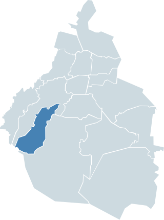
Iztapalapa is a borough in Mexico City, located on the east side of the entity. The borough is named after and centered on the formerly independent municipality of Iztapalapa, which is officially called Iztapalapa de Cuitláhuac for disambiguation purposes. The rest is made up of a number of other communities which are governed by the city of Iztapalapa.

<span class="mw-page-title-main">Tláhuac</span> Borough in Mexico City, Mexico

Tláhuac is a borough in the Mexico City, located in the southeastern edge of the entity. Though Tláhuac still contains rural communities within its borders, mostly in the southern and eastern portions, the borough has undergone a massive shift from urbanization, especially in its northwest. Tláhuac has experienced the fastest rate of population growth in Mexico City since the 1960s.

<span class="mw-page-title-main">Magdalena Contreras</span>

La Magdalena Contreras is a borough in the Mexico City. As of the 2010 census, it has a population of 239,086 inhabitants and is the third-least populous of Mexico City's boroughs. It lies at an elevation of 2,365 m (7,759 ft) above sea level. It is named after two historically important communities—La Magdalena Atlitic and Colonia Contreras. The northern end of the borough is urbanized. The rest of Magdalena Contreras, with its mountains and ravines, is designated as a conservation zone. However, urban sprawl has put pressure on these conservation areas. In an effort to preserve the area's forests and natural resources, the borough government has started promoting ecotourism. The largest ecotourism park is Los Dinamos where canyons and ravines are cut by streams and freshwater springs that eventually form the Río Magdalena, Mexico City’s only remaining free-flowing river.

<span class="mw-page-title-main">Teotihuacán Municipality</span> Municipality in State of Mexico, Mexico

Teotihuacán is a municipality located in the State of Mexico. The municipal seat is the town of Teotihuacán de Arista. It is in the northeast of the Valley of Mexico, 45 km northeast of Mexico City and 119 km from the state capital of Toluca. Teotihuacan takes its name from the ancient city and World Heritage site that is located next to the municipal seat. "Teotihuacan" is from Nahuatl and means "place of the gods." In Nahua mythology the sun and the moon were created here. The seal of the municipality features the Pyramid of the Sun from the archeological site, which represents the four cardinal directions. The building is tied to a character that represents water which is linked to an arm that is joined to the head of an indigenous person who is seated and speaking. This person represents a god. Much of the history of the area has been tied to the ancient city, most recently involves controversy connected with commerce and development around the site.

<span class="mw-page-title-main">Cuicuilco</span>

Cuicuilco is an important archaeological site located on the southern shore of Lake Texcoco in the southeastern Valley of Mexico, in what is today the borough of Tlalpan in Mexico City. Some historians believe this settlement goes back to 1400 BC. Other historians believe the pyramid could be the oldest building in the Americas circa 6,500 BC.

<span class="mw-page-title-main">Cerro de la Estrella (archaeological site)</span>

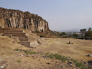
Cerro de la Estrella is a Mesoamerican archaeological site located in southeastern Central Mexico's Valley of Mexico, in the Iztapalapa alcaldía of Mexico City at an elevation of 2460 meters (8070 ft) above sea level, hence its Summit is 224 m over the Valley of Mexico level. At the southeast edge of what was the Great Texcoco Lake.

<span class="mw-page-title-main">Iztapalapa metro station</span> Mexico City metro station

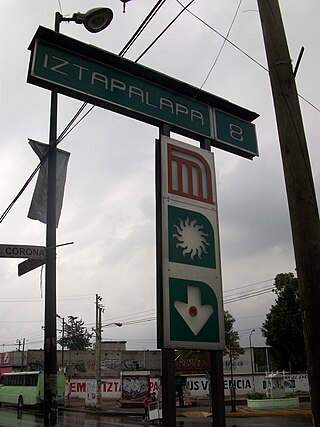
Iztapalapa is a station along Line 8 of the metro of Mexico City. It is located on the Calzada Ermita Iztapalapa in the Colonia El Santuario neighborhood of Iztapalapa borough on the southeast side of the city.

<span class="mw-page-title-main">Cerro de la Estrella metro station</span> Mexico City metro station

Cerro de la Estrella is an underground station along Line 8 of the metro of Mexico City. The station is located along the Calzada Ermita-Iztapalapa and serves the Colonia Hidalgo y Mina neighborhood within the Iztapalapa borough on the east side of the city. The station is named for the Cerro de la Estrella – a mesoamerican archaeological site located nearby. It was opened on 20 July 1994.

<span class="mw-page-title-main">Apaxco</span> Municipality and town in Mexico, Mexico

Apaxco is a municipality located in the Zumpango Region in Mexico. The municipal territory is located at a southern pass leading out of the Mezquital Valley about 288 km (179 mi) northeast of the state capital of Toluca. The name Apaxco comes from Nahuatl.

<span class="mw-page-title-main">Teotenango</span> Pre-hispanic fortified city in the Valley of Toluca

Teotenango was an important pre-Hispanic fortified city located in the southern part of the Valley of Toluca. It was initially founded during the last stages of the Teotihuacan civilization by a group generally referred to as the “Teotenancas.” Later, the Matlatzincas conquered the city and expanded it. The city existed for about 1,000 years, being abandoned only after the Spanish Conquest of the Aztec Empire.

El Cóporo is a prehispanic archaeological site at the northern frontiers of the Mesoamerican cultural area, located at an elevation of 150 meters on the western slopes of the Santa Bárbara range, near the San José del Torreón community, and lies some 15 kilometres (9 mi) due south of its municipal seat and largest township, on the northwestern corner of Guanajuato state, Mexico.

<span class="mw-page-title-main">Cerro de las Minas</span>

Cerro de la Minas is an archaeological site located in the modern state of Oaxaca, just to the north of the city of Huajuapan de León. The site belongs to what is called the Ñuiñe, or lowland/hot lands Mixtec cultural area. The site is located on a hill that dominates the Valley of Huajuapan, in what are now the neighborhoods of Chapultepec, Santa Rosa, Alta Vista and Del Maestro of the city. This large hill is in a strategic position over the farmlands of the valley, which provided it with its food, as well as the trade routes that cross this valley, which made it regionally important. The site contains a number of settlements and was reserved for the elite of that area during that time. Cerro de las Minas is the only lowland Mixtec archeological site open to the public.

<span class="mw-page-title-main">Spring equinox in Teotihuacán</span>

Spring equinox in Teotihuacán is an annual event which takes place around the 20th and 21st of March at the pre-Hispanic site of Teotihuacán, Mexico. This event is mirrored by other similar events in other pre-Hispanic sites such as Chichén Itzá and Malinalco, Mexico State.

<span class="mw-page-title-main">Cuahilama</span>

Cuahilama is a Hill and an archaeological site located south east of Santa Cruz Acalpixca, in the Cuahilama neighborhood, near the Xochimilco Archaeological Museum, in Mexico City. It was a ceremonial center, in the hill are prehispanic images engraved in basaltic rock.

<span class="mw-page-title-main">Huapalcalco</span> Pre-Columbian Mesoamerican archeological site

Huapalcalco is a pre-Columbian Mesoamerican archeological site located some 5 kilometers north of Tulancingo in the state of Hidalgo, Mexico.

<span class="mw-page-title-main">Xihuacan</span>

Xihuacan is a Mesoamerican archeological site located on the Costa Grande of the Mexican state of Guerrero, near the small town of La Soledad de Maciel, and the larger towns of Zihuatanejo and Petatlán. While pieces had been found at the site earlier, including the King of La Chole stele and Mesoamerican ball court rings, formal excavations were only recently begun. The site had been occupied for over 3,000 years and by three cultures, with contact with other Mesoamerican cultures such as the Teotihuacan and Olmec. Explored areas include what may be the largest Mesoamerican ball court, a 1-hectare (2.5-acre) pyramidal base and a hill with petroglyphs and a probable sacrifice stone.

<span class="mw-page-title-main">Pueblo Culhuacán</span> Neighborhood of Mexico City in Iztapalapa

Pueblo Culhuacán is an officially designated neighborhood of the Iztapalapa borough of Mexico City, which used to be a major pre-Hispanic city. Ancient Culhuacán was founded around 600 CE and the site has been continuously occupied since. The city was conquered by the Aztecs in the 15th century, but the Aztecs considered the city to have status with early rulers marrying into Culhua nobility to legitimize themselves. After the Spanish conquest of the Aztec Empire, the Franciscans and later the Augustinians made Culhuacán a major evangelization center, with the latter building the monastery complex which remains to this day. Today, Culhucan is fully integrated into Mexico City physically and politically. This area was designated as a "Barrio Mágico" by the city in 2011.

Cerro de la Estrella may refer to:

<i>Passion Play of Iztapalapa</i>

The Passion Play of Iztapalapa is an annual event during Holy Week in the Iztapalapa borough of Mexico City. It one of the oldest and most elaborate passion plays in Mexico as well as the best known, covered by media both in Mexico and abroad. Unlike others in Latin America, its origins are not in the colonial period but rather in a cholera epidemic in the 19th century, which gave rise to a procession to petition relief. Over time, the procession included a passion play which grew to include various scenes related to Holy Week. Today, the play includes not only hundreds of actors but also thousands of men called “Nazarenes” who carry their own crosses to follow the actor chosen to play Jesus to the site where the crucifixion is reenacted. While the event is still primarily religious, it has also become a rite of identity for Iztapalapa as well as a major tourism attraction for both the borough and the city.

References

  1. 1 2 3 4 5 6 7 8 9 10 "Parque Cerro de la Estrella" [Cerro de la Estrella Park] (in Spanish). Mexico City: Borough of Iztapalapa. Retrieved June 12, 2012.[ permanent dead link ]
  2. 1 2 3 4 5 6 7 Carlos Paul (August 3, 2011). "Invasión de paracaidistas pone en riesgo valiosos bienes culturales, denuncian" [Denounce invasion of illegal settlers putting valuable cultural riches at risk]. La Jornada (in Spanish). Mexico City. p. 7. Retrieved June 12, 2012.
  3. 1 2 3 4 "Arqueología" [Archeology] (in Spanish). Mexico City: Government of Mexico City. Archived from the original on May 24, 2012. Retrieved June 12, 2012.
  4. 1 2 3 4 5 6 "Parque Nacional Cerro de la Estrella" [Cerro de la Estrella National Park] (in Spanish). Mexico: Instituto Latinoamericano de la Comunicación Educativa. Archived from the original on May 15, 2011. Retrieved June 12, 2012.
  5. 1 2 "Ubicación del Museo del Fuego Nuevo" [Location of the New Fire Museum] (in Spanish). Mexico City: Borough of Iztapalapa. Archived from the original on July 22, 2007. Retrieved June 12, 2012.
  6. "Se unen expertos a la conservación integral del Cerro de la Estrella" [Gather together experts to conserve the integrity of Cerro de la Estrella]. Excelsior (in Spanish). Mexico City. April 28, 2007. Retrieved June 12, 2012.
  7. 1 2 3 4 5 Tatiana Adalid (April 18, 1999). "Cerro de la Estrella: Drama Ecologico" [Cerro de la Estrella:Ecological Drama]. Reforma (in Spanish). Mexico City. p. 1.
  8. 1 2 3 4 5 "Pendiente, la declaratoria del Cerro de la Estrella" [Pending a declaration for the Cerro de la Estrella]. Milenio (in Spanish). Mexico City. April 2, 2007. Archived from the original on January 29, 2013. Retrieved June 12, 2012.
  9. 1 2 3 4 "Méndez Martínez, Enrique Cerro de la Estrella, INAH Official Web Page" (in Spanish). INAH. Archived from the original on 2010-12-15. Retrieved 12 June 2012.
  10. Yanireth Israde (August 2, 2007). "Revela Iztapalapa su Templo Mayor" [Iztapalapa reveals its Grand Temple]. Reforma (in Spanish). Mexico City. p. 6.
  11. 1 2 3 Laura Castellanos (May 11, 2006). "Defienden Cerro de la Estrella" [They defend Cerro de la Estrella]. Reforma (in Spanish). Mexico City. p. 6.
  12. 1 2 "Inauguran barda perimetral del Cerro de la Estrella" [Inaugurate the perimeter wall of the Cerro de la Estrella]. NOTIMEX (in Spanish). Mexico City. February 2, 2009. p. 6.

Coordinates: 19°20′39.08″N99°5′28.27″W / 19.3441889°N 99.0911861°W / 19.3441889; -99.0911861