Peru is a country on the central western coast of South America facing the Pacific Ocean. It lies wholly in the Southern Hemisphere, its northernmost extreme reaching to 1.8 minutes of latitude or about 3.3 kilometres (2.1 mi) south of the equator. Peru shares land borders with Ecuador, Colombia, Brazil, Bolivia, and Chile, with its longest land border shared with Brazil.
The Department of Lima, known as the Department of the Capital until 1823, is a department and region located in the central coast of Peru; the seat of the regional government is Huacho.

In Latin America, tierra fría are mountain locations where high elevation results in a markedly cooler climate than that encountered in the lowlands at a comparable latitude. The combination of low latitude and high altitude — typically between approximately 2,000 m and 3,500 m in locations within 10° of the equator — produces a climate that falls into the same category as many oceanic climates found along the west coasts of the continents within the temperate zones — mild temperatures all year round, with monthly averages ranging from about 10°C (50°F) in the coldest months to about 18°C (64.4°F) in the warmest months. Common crops grown in the tierra fría are potatoes, wheat, barley, oats, corn, and rye.

The Sechura Desert is a coastal desert located south of the Piura Region of Peru along the Pacific coast and inland to the foothills of the Andes Mountains. Its extreme aridity is caused by the upwelling of cold coastal waters and subtropical atmospheric subsidence, but it is also subject to occasional flooding during El Niño years. In 1728, the town of Sechura was destroyed by a tsunami and was later rebuilt in its present location. In 1998, runoff from flooding rivers caused the formation of a temporary lake some 145 km (90 mi) long filling the Bayóvar Depression. Short rivers flowing across the desert from the Andes support intensive irrigation-based agriculture.

Páramo may refer to a variety of alpine tundra ecosystems located in the Andes Mountain Range, South America. Some ecologists describe the páramo broadly as "all high, tropical, montane vegetation above the continuous timberline". A narrower term classifies the páramo according to its regional placement in the northern Andes of South America and adjacent southern Central America. The páramo is the ecosystem of the regions above the continuous forest line, yet below the permanent snowline. It is a "Neotropical high mountain biome with a vegetation composed mainly of giant rosette plants, shrubs and grasses". According to scientists, páramos may be "evolutionary hot spots", that meaning that it's among the fastest evolving regions on Earth.

The Yungas is a bioregion of a narrow band of forest along the eastern slope of the Andes Mountains from Peru and Bolivia, and extends into Northwest Argentina at the slope of the Andes pre-cordillera. It is a transitional zone between the Andean highlands and the eastern forests. Like the surrounding areas, the Yungas belong to the Neotropical realm; the climate is rainy, humid, and warm.

Quechua is one of the eight Natural Regions of Peru and is between 2,300 and 3,500 m above sea level. It is composed of big valleys divided by rivers fed by estival rains.
Lomas, also called fog oases and mist oases, are areas of fog-watered vegetation in the coastal desert of Peru and northern Chile.

When the Spanish arrived, they divided Peru into three main regions: the coastal region, that is bounded by the Pacific Ocean; the highlands, that is located on the Andean Heights, and the jungle, that is located on the Amazonian Jungle. But Javier Pulgar Vidal, a geographer who studied the biogeographic reality of the Peruvian territory for a long time, proposed the creation of eight Natural Regions. In 1941, he presented his thesis "Las Ocho Regiones Naturales del Perú" at the III General Assembly of the Pan-American Institute of Geography and History.

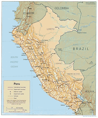
Climate of Peru describes the diverse climates of this large South American country with an area of 1,285,216 km2 (496,225 sq mi). Peru is located entirely in the tropics but features desert and mountain climates as well as tropical rainforests. Elevations above sea level in the country range from −37 to 6,778 m and precipitation ranges from less than 20 mm (0.79 in) annually to more than 8,000 mm (310 in). There are three main climatic regions: the Pacific Ocean coast is one of the driest deserts in the world but with some unique features; the high Andes mountains have a variety of microclimates depending on elevation and exposure and with temperatures and precipitation from temperate to polar and wet to dry; and the Amazon basin has tropical climates, mostly with abundant precipitation, along with sub-tropical climates in elevations above 1,550 m (5,090 ft).

The puna grassland ecoregion, of the montane grasslands and shrublands biome, is found in the central Andes Mountains of South America. It is considered one of the eight Natural Regions in Peru, but extends south, across Chile, Bolivia, and western northwest Argentina. The term puna encompasses diverse ecosystems of the high Central Andes above 3200–3400 m.

Llanos de Challe National Park is located on the Pacific coast of the Atacama Region, Chile. The park's mountains are moistened by the Camanchaca, creating a fog and mist-fed ecosystem called lomas. The park is one of the southernmost locations of the lomas which are scattered along the coastal desert from northern Chile to northern Peru. The highest elevation in the park is Cerro Negro at 950 m.

Garúa is a Spanish word meaning drizzle or mist. Although used in other contexts in the Spanish-speaking world, garúa most importantly refers to the moist cold fog that blankets the coasts of Peru, southern Ecuador, and northern Chile, especially during the southern hemisphere winter. In Chile, a similar fog is called camanchaca. Garúa brings mild temperatures and high humidity to a tropical coastal desert. It also provides moisture from fog and mist to a nearly-rainless region and permits the existence of vegetated fog oases, called lomas.

The Atacama Desert is a desert plateau located on the Pacific coast of South America, in the north of Chile. Stretching over a 1,600 km (990 mi) strip of land west of the Andes Mountains, it covers an area of 105,000 km2 (41,000 sq mi), which increases to 128,000 km2 (49,000 sq mi) if the barren lower slopes of the Andes are included.
Farallones de Cali is a cluster of mountains in the West Andes of Colombia. It is located west of the city of Cali and gives rise to many of the rivers that provide water and electricity to Cali. The PNN Farallones de Cali encompasses 150,000 ha (580 sq mi) in the mountains as well as much of the Pacific slope and is an area of very high biodiversity. The average temperature ranges from 25 °C (77 °F) in the tropical foothills to 5 °C (41 °F) in the páramo. In this territory are located the district of Pichinde, Andes and Leonera, and two villages Penas Blancas and Lomas de la Cajita.

Lomas, also called fog oases and mist oases, are areas of fog-watered vegetation in the coastal desert of Peru and northern Chile. About 100 lomas near the Pacific Ocean are identified between 5°S and 30°S latitude, a north–south distance of about 2,800 kilometres (1,700 mi). Lomas range in size from a small vegetated area to more than 40,000 hectares and their flora includes many endemic species. Apart from river valleys and the lomas the coastal desert is almost without vegetation. Scholars have described individual lomas as "an island of vegetation in a virtual ocean of desert."

The Ocetá Páramo is a páramo, which means an ecosystem above the continuous forest line yet below the permanent snowline. This particular páramo is located at altitudes between 2,950 metres (9,680 ft) and 3,950 metres (12,960 ft) in the Eastern Ranges of the Colombian Andes. It covers parts of the municipalities Monguí, Mongua and Tópaga, belonging to the Sugamuxi Province, Boyacá. The Ocetá Páramo is known for its collection of small shrubs called frailejones, as well as other Andean flora and fauna. Hiking tours from Monguí or Mongua to the páramo take a full day.

The Northern Andean páramo (NT1006) is an ecoregion containing páramo vegetation above the treeline in the Andes of Colombia and Ecuador. In the past, when the climate was cooler, the treeline and the páramo units were lower and the units were connected. During the present warmer Holocene epoch the páramos have migrated uphill, shrinking and becoming isolated. They contain many rare or endangered species, some of them restricted to a narrow area of one mountain or mountain range. The ecoregion is relatively well preserved, but faces threats from over-grazing and farming.

The Santa Marta páramo (NT1007) is an ecoregion containing páramo vegetation above the treeline in the Sierra Nevada de Santa Marta mountain range on the Caribbean coast of Colombia. The isolated position of the range has allowed unique species to evolve. Some are related to those found in Central America and the Caribbean coastal areas, and some to species from the Andes. The habitat is relatively stable, but has been drastically changed from the original by long-term human activity.

The Cordillera Central páramo (NT1004) is an ecoregion containing páramo vegetation above the treeline in the Andes mountain range of northern Peru and southern Ecuador. Due to its isolation there are high levels of endemism. Despite many human settlements and some destruction of habitat by agriculture and mining, the ecoregion is relatively intact.

