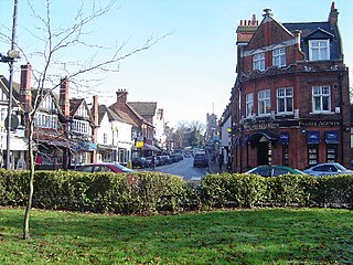
Pinner is a suburb in the London Borough of Harrow, northwest London, England, 12 miles (19 km) northwest of Charing Cross, close to the border with Hillingdon, historically in the county of Middlesex. The population was 38,698 in 2021.
Somers Town is an inner-city district in North West London. It has been strongly influenced by the three mainline north London railway termini: Euston (1838), St Pancras (1868) and King's Cross (1852), together with the Midland Railway Somers Town Goods Depot (1887) next to St Pancras, where the British Library now stands. It was named after Charles Cocks, 1st Baron Somers (1725–1806). The area was originally granted by William III to John Somers (1651–1716), Lord Chancellor and Baron Somers of Evesham.
Kingsthorpe is a suburb and civil parish of Northampton, England. It is situated to the north of Northampton town centre and is served by the A508 and A5199 roads which join at Kingsthorpe's centre. The 2011 Census recorded the population of the district council ward as 4,477.

Bristol, the largest city in South West England, has an eclectic combination of architectural styles, ranging from the medieval to 20th century brutalism and beyond. During the mid-19th century, Bristol Byzantine, an architectural style unique to the city, was developed, and several examples have survived.
There are 212 Grade II* listed buildings in Bristol, England.
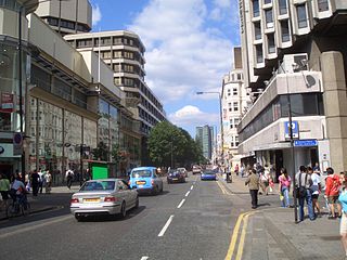
The A400 road is an A road in London that runs from Charing Cross to Archway in North London. It passes some of London's most famous landmarks.
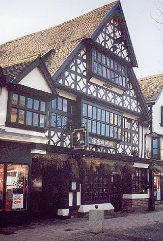
The Tudor Tavern at No 15 Fore Street, Taunton, Somerset, England has been designated as a Grade I listed building. Built in 1578, the house is three storeys high of a timber-frame construction, with jettied first and second floors. The frontage is of carved bressummers with interlocking curved braces, while the roof is red tiles. There is a medieval hall with an open trussed roof behind the front.

There are 72 Grade II* listed buildings in the city of Brighton and Hove, England. The city, on the English Channel coast approximately 52 miles (84 km) south of London, was formed as a unitary authority in 1997 by the merger of the neighbouring towns of Brighton and Hove. Queen Elizabeth II granted city status in 2000.

The Ossulston Estate is a multi-storey council estate built by the London County Council on Chalton Street in Somers Town between 1927 and 1931. It was unusual at the time both in its inner-city location and in its modernist design, and all the original parts of the estate are now Grade II listed buildings.

Spa Road in the City of Gloucester runs between the junction of Southgate Street and Llanthony Road in the north and Montpellier in the South. It is joined by Brunswick Road on its north side. It contains a number of listed buildings.

Chalton Street Market is a street market in Camden, North London.

Regent Square is a public square and street in the London Borough of Camden in London, England. It is located near Kings Cross and Bloomsbury.

Marchmont Street is located in the London Borough of Camden. It is the main high street serving southern Kings Cross and eastern Bloomsbury. It links the Brunswick Centre and Russell Square tube station at its south to Tavistock Place at its north, where it becomes Cartwright Gardens.

Camley Street is a street in the London Borough of Camden in London, England. It lies in St Pancras and King's Cross: stretching over a kilometre from St Pancras railway station in the south, over the Regent's Canal, and to Agar Grove in the north.

Chalcot Square is a garden square in the Primrose Hill district of London, England.

The Blythe Hill Tavern is a grade II listed public house in Forest Hill, south London.

Gloucester Avenue is a street in the Primrose Hill area of London, England. Located in the London Borough of Camden, it is a residential road featuring many nineteenth century properties including several pubs as well as the neo-Georgian Cecil Sharp House. For much of its route it runs adjacent to the West Coast Main Line out of Euston Station.

Oakley Square is a crescent-shaped garden square in Somers Town in Central London, close to Mornington Crescent and Camden Town. It is located in the London Borough of Camden and runs roughly northeastwards from Eversholt Street meeting with the southern end of Camden Street on its eastern side.

Well Walk is a street in Hampstead, England located in the London Borough of Camden. It runs southwestwards from Hampstead Heath to Flask Walk which then continues on towards the centre of Hampstead Village around the Hampstead tube station. It takes its name from the historic Hampstead Wells.

Flask Walk is a street in Hampstead in the London Borough of Camden. It runs eastwards from Hampstead High Street to a junction with Well Walk and New End Square. It is primarily residential but the western end of the street is a pedestrianised alley featuring commercial properties. Hampstead tube station is located close to the junction with the High Street.
