
Mysore, officially Mysuru, is a metropolitan city in the southern Indian state of Karnataka. It is the state's second-most populous and is one of the cleanest cities in India according to the Swachh Survekshan. It is the seat of the Wadiyar dynasty and was the capital of the Kingdom of Mysore for almost six centuries, from 1399 until 1947. It is currently the headquarters of Mysore district and Mysore division. Known for its heritage structures and palaces, including the famous Mysore Palace, and noted for its culture, Mysore is popularly known as the "City of Palaces", the "Heritage City", and the "Cultural Capital of Karnataka". For its pristine and calm ambience, it is also known as "Pensioners' Paradise".

Kodagu district is an administrative district in the Karnataka state of India. Before 1956, it was an administratively separate Coorg State, at which point it was merged into an enlarged Mysore State.
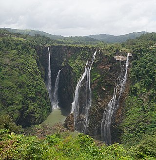
Jog Falls is a waterfall on the Sharavati river located in Siddapura taluk, Uttara Kannada District and its view point located in Shimoga district of Karnataka, India. It is the second highest plunge waterfall in India. It is a segmented waterfall which depends on rain and season to become a plunge waterfall. The falls are major attractions for tourists and is ranked 36th in the list of free-falling waterfalls, 490th in the world by list of waterfalls by total height, 128th in the list of single-drop waterfalls in the World by the waterfall database.
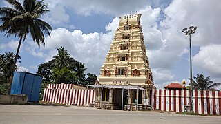
Nanjangud, officially known as Nanjanagudu, is a town in the Mysuru district of Indian state of Karnataka. Nanjangud lies on the banks of the river Kapila, 23 km from the city of Mysore. Nanjangud is famous for the Srikanteshwara Temple located here. Nanjangud is also called Dakshina Kashi. This town is also famous for a type of banana grown in the region called the Nanjanagoodu rasabale. Nanjangud's local administrative unit was designated as a Municipal Committee in 2015 by including Devirammanahalli and Kallahalli village.

The Kabini River is one of the major tributaries of the river Cauvery in southern India. It originates near Kavilumpara in Kozhikode district of Kerala state by the confluence of the Panamaram River and the Mananthavady River. It flows eastward through Wayanad district, entering Mysore district of Karnataka, to join the Kaveri River in Mysore district of Karnataka

Namma Metro, also known as Bengaluru Metro, is a rapid transit system serving the city of Bengaluru, India. It is the second longest operational metro network in India with an operational length of 73.75 kilometers just behind Delhi Metro. Upon its inauguration, it became the first underground metro system in South India. Namma Metro has a mix of underground, at grade, and elevated stations. Out of the 66 operational metro stations of Namma Metro as of October 2023, there are 57 elevated stations, eight underground stations and one at-grade station. The system runs on standard-gauge tracks.

Chikkodi is a taluka and Town Municipal Council in the Belagavi district of Karnataka, India. It is a Subdivision of the district. Chikodi, Athani, Hukkeri, Raybag, Nipani and Kagwad are the taluks that come under Chikodi Subdivision. It is 75 kilometers from the city of Belgaum, 65 kilometers from Kolhapur, 51 kilometers from Miraj, 160 kilometers from Hubballi, and 570 kilometers from the capital of Karnataka state, Bengaluru. Chikodi has many district level offices but it is not designated as a district by the Government of Karnataka. It is one of the major cities that lies in the border between Karnataka and Maharashtra states.official language is Kannada.
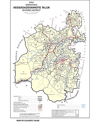
Heggadadevanakote or H.D.Kote is a town and a taluk headquarters in Mysore district in the Indian state of Karnataka. Kakana kote forest lies in Heggadadevana kote taluk. H.D Kote city is divided into 13 wards for which elections are held every 5 years.
Shaktinagar is a town in Raichur taluk and Raichur district in the Indian state of Karnataka. There is a coal-based thermal power plant is working by vst gang limited (vgl)

Karnataka, the sixth largest state in India, has been ranked as the third most popular state in the country for tourism in 2014. It is home to 507 of the 3600 centrally protected monuments in India, second only to Uttar Pradesh. The State Directorate of Archaeology and Museums protects an additional 752 monuments and another 25,000 monuments are yet to receive protection.

Karnataka is one of the highest economic growth states in India with an expected GSDP growth of 9.5% in the 2021–22 fiscal year. The total expected GSDP of Karnataka in 2022–2023 is about $240 billion. Karnataka recorded the highest growth rates in terms of GDP and per capita GDP in the last decade compared to other states. In 2008–09, the tertiary sector contributed the most to GSDP, followed by the secondary sector, and the primary sector.

Hubli Airport is a domestic airport serving the twin cities of Hubballi and Dharwad in the state of Karnataka, India. It is situated in Gandhi Nagar, 8 km (5.0 mi) from Hubballi and 20 km (12 mi) from Dharwad. It is connected with 10 destinations throughout the country. The airport has been made self-reliant in terms of electricity generation, with the commissioning of an 8 megawatt (MW) ground-mounted grid-connected photovoltaic solar plant in April 2021.
Many Ghat Roads can be found in the Nilgiris District of Tamil Nadu, Southern India. Nearly all of the district is located in the Nilgiri Hills, part of the Western Ghats mountains. This area borders the states of Karnataka and Kerala. The hills consequently can be reached by road from three states. Most of these Ghat Roads go through heavily forested mountains and contain a number of sharp hair-pin bends.
Sargur, is a small town located about 80 km from the town of Chamarajanagar And a Taluk of Mysore district of Karnataka, India. H D Kote (Heggadadevanakote) is about 12 km north of Sargur. It is 55 km from the city of Mysore. Bangalore International Airport is 200 km away. To be more elaborate, Sargur is 33.8 km from Nanjangud town (Karnataka), 35.1 km from Gundlupet town (Karnataka), 137.8 km from Udagamandalam town (Ooty) Valley and 38.8 km from Hunsur town (Karnataka).
Nilambur–Nanjangud line also called The golden I. T. corridor or Wayanad Railway, was a railway project to create a 5 ft 6in broad gauge rail connection from the town of Nanjangud (Karnataka) to Nilambur (Kerala) through Wayanad district of Kerala and Nilgiri district of Tamil Nadu.

Mysuru City Corporation (MCC) is the administrative body responsible for civic amenities and infrastructural assets of Mysuru in Karnataka, India. It is the third-largest municipal corporation in Karnataka, serving a population of 1,000,000 in an area of 235 km2. The city's boundaries have expanded more than twice between 2010 and 2020.

National Highway 766 is a National Highway in Southern India. NH 766 connects Kozhikode in Kerala with Kollegal in Karnataka via Mysore. Of the total distance of 272 km, 117 km is in Kerala and 155 is in Karnataka. At Kollegal, it joins National Highway 948, which connects Bengaluru and Coimbatore. The highway passes through dense forests of Western ghats of India. The NH-766 passes through 19.7 km Bandipur National Park and Wayanad wild life sanctuary.

Bangalore, officially Bengaluru, is the capital and largest city of the southern Indian state of Karnataka. It has a population of more than 8 million and a metropolitan population of around 15 million, making it India's third most populous city and fourth most populous urban agglomeration. It is the most populous city and largest urban agglomeration in South India, and is the 27th largest city in the world. Located on the Deccan Plateau, at a height of over 900 m (3,000 ft) above sea level, Bangalore has a pleasant climate throughout the year, with its parks and green spaces earning it the reputation of India's "Garden City". Its elevation is the highest of India's major cities.

