
Nahan is a town in Himachal Pradesh in India and is the headquarters of the Sirmaur District It was the capital of the former Sirmur princely state.

Pauri is a town and a municipal board in Pauri Garhwal district in the Indian state of Uttarakhand. Pauri is the seat of the Divisional Commissioner of the Garhwal Division.

Nangal is a town and municipal council in Ropar district in Punjab, India. It is 20 km from Una in the state of Himachal Pradesh in northwest India. It sits at the foot of the Shiwalik Hills where it was established after plans for a dam required the movement of previously established villages. Residential areas include Modern Avenue, Shivalik Avenue, Naya Nangal Township, BBMB Township and Nangal Basti area. Industrial areas include Focal Point, NFL Factory, PACL. Modern Avenue, Shivalik Avenue, Naya Nangal Township are parts of Naya Nangal. Naya Nangal is planned town with parks like Madhuvan Park, Captain Amol Kalia Park, with stadium like NFL Stadium. Naya Nangal also has Well established Recreational clubs, like Golf club, Officer's club, Swimming club, Race tracks and cycling tracks.

Ashta is a city and a municipality in Sehore district in the state of Madhya Pradesh, India. The nearest airport is in the city of Bhopal.

Barbigha is a city and a municipality in the Sheikhpura district of Bihar, India. It is well connected by road to the state capital of Patna. National highways NH33 and NH333A also pass through Barbigha, and Bihta-Sarmera four lane state highway passes from Gopalbad near it.
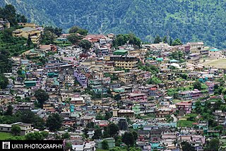
Gopeshwar is a township in the Garhwal hills and a municipal board within Chamoli district. It is the administrative headquarters of the Chamoli District of Uttarakhand in India. Located 1,550 m (5,090 ft) above sea level, it is famous for its weather and its temple Gopeshwar is known for his very beautiful temple "Gopinath" one can definitely experience the feeling of being there in Gopinath. Gopeshwar has a very beautiful kund that is Vaitrani.

Digapahandi is a town and a Notified Area Council (N.A.C.) in Ganjam district in the state of Odisha, India. There are 171 small villages which comes under Digapahandi tahasil and largely dependent on this town for their business and livelihood. Digapahandi town is divided into 11 wards, comprising Bazar street, Sunari street, New street, Phulasundari Street, Balaji Nagar Bada Brahmin street, Sana Brahmin street, Sasan street, Chikitia street, Rani street, Annapurna street, Anchala street, Uparabasa, Chikiti road.

Doharighat is a town and a nagar panchayat in Mau district in the state of Uttar Pradesh, India.
Dongargarh is a city and municipality in Rajnandgaon District in the state of Chhattisgarh, India and the site of the Bambleshwari Temple and Chandragiri Jain Temple. A prominent pilgrim destination in Rajnandgaon District, the city lies about 35 kilometres (22 mi) west from Rajnandgaon, 67 kilometres (42 mi) west from Durg and 132 kilometres (82 mi) east from Bhandara which are situated on National Highway 6. Featuring majestic mountains and ponds, Dongargarh is derived from the words: Dongarh meaning 'mountains' and garh meaning 'fort'. It is also a best tourism place in Chhattisgarh

Dugda is a census town in the Chandrapura CD block in the Bermo subdivision of the Bokaro district in the state of Jharkhand, India. It is a small township, constructed during the 1970s, situated under the foot of several small hills. Residents of the township are primarily employees of Dugda Coal Washery under Bharat Coking Coal Limited (BCCL).
Kasrawad is a tehsil and nagar panchayat in Khargone district in the Indian state of Madhya Pradesh.

Khrew or Khreuh is a town and notified area committee in Pulwama district in the Indian union territory of Jammu and Kashmir. It comes under Tehsil Pampore and District Pulwama of Union Territory of J&K. It is located at a distance of 22 km from Srinagar. It is famous for Jwala Ji Mandir which is a prominent place of worship for Kashmiri Hindus.
Maksi is a city and a municipality in Shajapur district in the Indian state of Madhya Pradesh. It is famous for Jain Temple of Maksi Parshwanathh Ji. Maksi has an ever buzzing market which is famous for sweet samosas.

Nainwan is a tehsil of Bundi district and a municipality in the Hadoti region of the state of Rajasthan in India.
Nichlaul is a town and a nagar panchayat in Maharajganj district in the Indian state of Uttar Pradesh. It is situated 25 km from district headquarter Maharajganj and 80 km from Gorakhpur. It is situated near the Indo-Nepal border.
Porsa is a town and a municipality in the Morena district of the Indian state of Madhya Pradesh.

Ramgarh Cantonment, usually referred to as Ramgarh Cantt or just Ramgarh is a cantonment town, belonging to the Ramgarh district of the Indian state of Jharkhand. Historically, a subdivision of the larger Hazaribag district, Ramgarh was finally elevated to a district status on 12 September 2007 largely to ease administrative hardships.
Sarila is a town, a former princely state and a nagar panchayat in Hamirpur district in the northern Indian state of Uttar Pradesh.

Vadnagar, वडनगर, is a town and a municipality in Mehsana district in the Indian state of Gujarat. Its ancient name was Anartapura. It was also known as Anandapura, and was one of Buddhist places visited by Xuanzang in 640. Alexander Cunningham, a historian and archaeologist, has identified Anandapura with Vadnagar. Vadnagar was also known as Skandhpur after Kartikeya, who is identified with Murugan. Vadnagar is also the birth place of current Prime Minister of India Republic Of India, Narendra Modi.

