
South Yorkshire is a ceremonial county in the Yorkshire and the Humber region of England. It borders North Yorkshire and West Yorkshire to the north, the East Riding of Yorkshire to the north-east, Lincolnshire and Nottinghamshire to the south-east, and Derbyshire to the south and west. The largest settlement is the city of Sheffield.

Glossop is a market town in the Borough of High Peak, Derbyshire, England. It is located 15 miles (24 km) east of Manchester, 24 miles (39 km) north-west of Sheffield and 32 miles (51 km) north of the county town, Matlock. Glossop lies near Derbyshire's borders with Cheshire, Greater Manchester, South Yorkshire and West Yorkshire. It is between 150 and 300 metres above sea level and is bounded by the Peak District National Park to the south, east and north.

Amber Valley is a local government district with borough status in the east of Derbyshire, England, taking its name from the River Amber. Its council is based in Ripley. The district covers a semi-rural area lying to the north of the city of Derby. The district contains four main towns whose economy was based on coal mining and remains to some extent influenced by engineering, distribution and manufacturing, holding for instance the headquarters and production site of Thorntons confectionery.

High Peak is a local government district with borough status in Derbyshire, England. The borough compromises high moorland plateau in the Dark Peak area of the Peak District National Park. The district stretches from Holme Moss in the north to Sterndale Moor in the south, and from Hague Bar in the west to Bamford in the east. The population of the borough taken at the 2011 Census was 90,892. The borough is unusual in having two administrative centres for its council, High Peak Borough Council; the offices are based in both Buxton and Glossop. The borough also contains other towns including Chapel-en-le-Frith, Hadfield, New Mills and Whaley Bridge.

Derbyshire Dales is a local government district in Derbyshire, England. The district was created in 1974 as West Derbyshire; the name was changed to Derbyshire Dales in 1987. The council is based in the town of Matlock, and the district also includes the towns of Ashbourne, Bakewell, Darley Dale and Wirksworth, as well as numerous villages and extensive rural areas. Much of the district is within the Peak District National Park.
Erewash is a local government district with borough status in Derbyshire, England. The borough is named after the River Erewash. The council has offices in both the borough's towns of Ilkeston and Long Eaton. The borough also includes several villages and surrounding rural areas. Some of the built-up areas in the east of the borough form part of the Nottingham Urban Area.

Whaley Bridge is a town and civil parish in the High Peak district of Derbyshire, England. It is situated on the River Goyt, 16 miles (26 km) south-east of Manchester, 7 miles (11 km) north of Buxton, 9 miles (14 km) north-east of Macclesfield and 28 miles (45 km) west of Sheffield. It had a population of 6,455 at the 2011 census, including Furness Vale, Horwich End, Bridgemont, Fernilee, Stoneheads and Taxal.

High Peak is a parliamentary constituency represented in the House of Commons of the UK Parliament since 2019 by Robert Largan, a Conservative.

Chapel-en-le-Frith railway station serves the Peak District town of Chapel-en-le-Frith, Derbyshire, England. It is 20+1⁄2 miles south east of Manchester Piccadilly on the Buxton Line from Manchester. It was built in 1863 for the London & North Western Railway, on its line from Whaley Bridge to Buxton as an extension of the Stockport, Disley and Whaley Bridge Railway.

Tintwistle Rural District was a local government district in north east Cheshire, England from 1894 to 1974.
Wycombe Rural District was, from 1894 to 1974, a rural district in the administrative county of Buckinghamshire, England.

High Peak Borough Council is the local authority for High Peak, a non-metropolitan district with borough status in Derbyshire, England. The administrative base of High Peak Borough Council is split between sites in the towns of Buxton and Glossop. Full council meetings are usually held at the Pavilion Gardens in Buxton. The council is elected every four years.

Bowers Coaches was a bus company based in Chapel-en-le-Frith, Derbyshire, England. The company operated bus and coach services in Cheshire East, Derbyshire and Greater Manchester from 1952 until 2012. In its later years, it was a subsidiary of Centrebus and in 2012 it was merged with the Dove Holes depot of Trent Barton to form High Peak Buses.

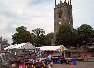
Chapel-en-le-Frith is a town and civil parish in the Borough of High Peak in Derbyshire, England.
The first elections to High Peak Borough Council in Derbyshire, England were held in 1973. The Borough Council was formed by absorbing the municipal boroughs of Buxton and Glossop, the urban districts of New Mills and Whaley Bridge, and the rural districts of Chapel-en-le-Frith and Tintwistle.

Buxton was an Urban District from 1894 to 1917 and a Municipal Borough from 1917 to 1974 in Derbyshire, England.

Glossop was a Municipal Borough in Derbyshire, England from 1866 to 1974. It was created under the Municipal Corporations Act 1835.

New Mills was an Urban District in Derbyshire, England from 1894 to 1974. It was created under the Local Government Act 1894. The district was abolished in 1974 under the Local Government Act 1972 and combined with the Buxton and Glossop Municipal Boroughs, the Whaley Bridge Urban District and the Chapel en le Frith and Tintwistle Rural Districts to form the new High Peak district.

Chinley, Buxworth and Brownside is a civil parish within the High Peak district, which is in the county of Derbyshire, England. Partially rural with several villages contained within, its population was 2,796 residents in the 2011 census. The parish is 150 miles (240 km) north west of London, 35 miles (56 km) north west of the county city of Derby, and 1+1⁄3 miles (2.1 km) north of the nearest market town of Chapel-en-le-Frith. Being on the edge of the county border, it shares a boundary with the parishes of Chapel-en-le-Frith, Edale, Hayfield, New Mills and Whaley Bridge. A substantial portion of the parish is within the Peak District national park.

