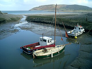
Porlock is a coastal village in Somerset, England, 5 miles (8 km) west of Minehead. It has a population of 1,440.

Dunster is a village, civil parish and former manor within the English county of Somerset, today just within the north-eastern boundary of the Exmoor National Park. It lies on the Bristol Channel coast 2.5 miles (4 km) south-southeast of Minehead and 20 miles (32 km) northwest of Taunton. The United Kingdom Census of 2011 recorded a parish population of 817.

Dunkery Beacon at the summit of Dunkery Hill is the highest point on Exmoor and in Somerset, England. It is also the highest point in southern England outside of Dartmoor.

Holnicote in the parish of Selworthy, West Somerset, England, is a historic estate consisting of 12,420 acres of land, much situated within the Exmoor National Park.

Winsford is a village and civil parish in Somerset, England, located about 5 miles (8 km) north-west of Dulverton.

Luccombe or Luckham is a village and civil parish in the Exmoor National Park in the English county of Somerset. It at the foot of the moor's highest hill, the 1,750 feet (533 m) Dunkery Beacon, and is about one mile south of the A39 road between Porlock and Minehead. Administratively it forms part of the district of Somerset West and Taunton. The parish includes the hamlets of Stoke Pero and Horner, as well as the former hamlet of Wilmersham.

Blackford is a village and former civil parish in the county of Somerset, England, beside the A303 road, 4 miles (6.4 km) south west of Wincanton in the South Somerset district. There are two other places called Blackford in Somerset: one is a village near Wedmore, the other a tiny hamlet in Selworthy parish between Porlock and Minehead.

Roadwater is a village 3 miles (5 km) south-west of Williton, on the northern edge of the Exmoor National Park, in Somerset, England.

Selworthy is a small village and civil parish 5 kilometres (3 mi) from Minehead in Somerset, England. It is located in the National Trust's Holnicote Estate on the northern fringes of Exmoor. The parish includes the hamlets of Bossington, Tivington, Lynch, Brandish Street and Allerford.
Minehead Without is a civil parish in the English county of Somerset, and within the Exmoor National Park. As its name suggests, the parish covers a rural area to the west of, but not including, the small coastal town of Minehead. The parish's principal settlement is the hamlet of Bratton.
The parish Church of St Mary in Luccombe, Somerset, England has a chancel dating from about 1300, with the nave and tower being added around 1450. It has been designated as a Grade I listed building.

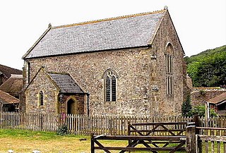
The Church of St Dubricius in Porlock, Somerset, England dates from the 13th century. The church has been designated by English Heritage as a Grade I listed building.

The Old St James's Church is a former church in the village of Upton, Somerset, England, of which only the tower remains, overlooking Wimbleball Lake. The tower is recorded in the National Heritage List for England as a designated Grade II* listed building, and is in the care of the Churches Conservation Trust. The church was declared redundant on 4 November 1971, and was vested in the Trust on 24 May 1973.
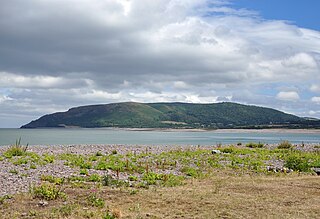
Selworthy Beacon is a hill and Marilyn of Exmoor in Somerset, England. It lies within the boundaries of Exmoor National Park, to the north of the village of Selworthy and northwest of Minehead. A road leads to the top, where there is a National Trust plaque and a view of the south coast of Wales across the Bristol Channel. The South West Coast Path also climbs the hill and ends slightly shy of the summit.

Richard Phelps (1710–1785) was an 18th-century English portrait painter and designer. He painted portraits of gentry, a number of which are in the National Trust, Dunster Castle, University of Oxford, National Portrait Gallery, London, and other museums. The British Museum has an album of 312 of his drawings. Phelps was also a landscape designer, who was hired by Henry Fownes Luttrell to update the grounds of Dunster Castle.
The Anglican Church of St Bartholomew in Rodhuish, Somerset, England was built in the 15th century. It is a Grade II* listed building.

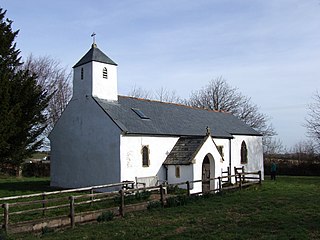
Stoke Pero Church in Stoke Pero, Somerset, England was built in the 13th century. It is a Grade II* listed building. Standing 1013 feet above sea level, it is the highest church on Exmoor.

The Anglican Church of St Andrew in Withypool, Somerset, England was built in late medieval period. It is a Grade II* listed building.
The Anglican Lynch Chapel Of Ease in West Lynch, Selworthy, Somerset, England was built around 1530. It is a Grade II* listed building.
West Somerset was a local government district located in the English county of Somerset. It merged with Taunton Deane to form Somerset West and Taunton on 1 April 2019.

