
Kenton is a town in Kent County, Delaware, United States. It is part of the Dover, Delaware Metropolitan Statistical Area. The population was 261 at the 2010 census.

Little Creek is a town in Kent County, Delaware, United States. It is part of the Dover, Delaware Metropolitan Statistical Area. The population was 224 at the 2010 census.
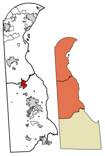
Smyrna is a town in Kent and New Castle counties in the U.S. state of Delaware. It is part of the Dover, Delaware Metropolitan Statistical Area. According to the Census Bureau, as of 2010, the population of the town is 10,023.

Woodside is a town in Kent County, Delaware, United States. It is part of the Dover, Delaware Metropolitan Statistical Area. The population was 181 at the 2010 census.

Montchanin is an unincorporated community in New Castle County, Delaware, United States. Montchanin is located at the intersection of Delaware Route 100 and Kirk Road to the northwest of Wilmington.

Talleyville is an unincorporated community in New Castle County, Delaware, United States. Talleyville is located at the intersection of U.S. Route 202, Mt. Lebanon Road, and Silverside Road to the north of Wilmington. Its ZIP code is 19803.
Ashland is an unincorporated community in New Castle County, Delaware, United States. Ashland is located at the intersection of Delaware Route 82 and Barley Mill Road along the Red Clay Creek.
Mount Cuba is an unincorporated community in New Castle County, Delaware, United States. Mount Cuba is located at the intersection of Delaware Route 82 and Mount Cuba Road along the east bank of the Red Clay Creek. The Mount Cuba Historic District was listed on the National Register of Historic Places in 1979.
Wooddale is an unincorporated community in New Castle County, Delaware, United States. Wooddale is located along the Red Clay Creek and West Rolling Mill Road west of Wilmington. The Wooddale Historic District and Wooddale Bridge are listed on the National Register of Historic Places.
Stanton is an unincorporated community in New Castle County, Delaware, United States, near the confluence of the Red Clay and White Clay Creeks. It is located in the southern end of Mill Creek Hundred.
Sandtown is an unincorporated community in Kent County, Delaware, United States. Sandtown is located on Delaware Route 10 just east of the Maryland border.

Woodland Beach is an unincorporated community in Kent County, Delaware, United States. Woodland Beach is along the Delaware Bay east of Smyrna at the eastern terminus of Delaware Route 6. The Woodland Beach Wildlife Area is located in Woodland Beach.
Mount Pleasant is an unincorporated community located largely in St. George's Hundred, New Castle County, Delaware, United States. Mount Pleasant is located at the intersection of Delaware Route 71 and Delaware Route 896 north of Middletown. The A. Eliason House, Idalia Manor, and Woodside are listed on the National Register of Historic Places.

South Bowers is an unincorporated community in Kent County, Delaware, United States. South Bowers is located on the Delaware Bay on the south side of the Murderkill River opposite Bowers. It was a part of the James D. Sipple home farm containing 421 acres of upland, marsh and beachland and he subdivided a small part of the farm into the lots comprising South Bowers before he died in 1890. His son, James H. Sipple acquired the interests of his siblings and conveyed the farm to his daughter, Sarah E. Webb in 1920.
Dutch Neck Crossroads is an unincorporated community in Kent County, Delaware, United States. Dutch Neck Crossroads is located on Delaware Route 9 4.9 miles (7.9 km) east of Smyrna. The Allee House, which is listed on the National Register of Historic Places, is located in Dutch Neck Crossroads.

Cowgills Corner is an unincorporated community in Kent County, Delaware, United States. Cowgills Corner is located on Delaware Route 9 3.5 miles (5.6 km) northeast of Dover. The Octagonal Schoolhouse, which is listed on the National Register of Historic Places, is located in Cowgills Corner.

Mastens Corner is an unincorporated community in Kent County, Delaware, United States. Mastens Corner is located at the intersection of Hopkins Cemetery Road and Hills Market Road 3.8 miles (6.1 km) northwest of Harrington.

Pond Eddy is an unincorporated community in Shohola Township, Pike County, Pennsylvania, United States.
McClellandville is an unincorporated community in New Castle County, in the U.S. state of Delaware. McClellandville is located at the intersection of Delaware Route 896 and Wedgewood Road northwest of Newark.
Williamsville is an unincorporated community in Kent County, Delaware, United States. Williamsville is located at the intersection of Williamsville Road and Deep Grass Lane south of Houston.


