Related Research Articles

Fluvanna County is a county located in the Piedmont region of the Commonwealth of Virginia. As of the 2020 census, the population was 27,249. Its county seat is Palmyra, while the most populous community is the census designated place of Lake Monticello.
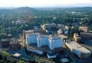
Charlottesville, colloquially known as C'ville, is an independent city in the Commonwealth of Virginia. It is the county seat of Albemarle County, which surrounds the city, though the two are separate legal entities. It is named after Queen Charlotte. As of the 2020 census, the population was 46,553. The Bureau of Economic Analysis combines the City of Charlottesville with Albemarle County for statistical purposes, bringing its population to approximately 150,000. Charlottesville is the heart of the Charlottesville metropolitan area, which includes Albemarle, Buckingham, Fluvanna, Greene, and Nelson counties.

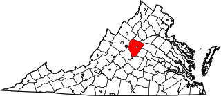
Albemarle County is a county located in the Piedmont region of the Commonwealth of Virginia. Its county seat is Charlottesville, which is an independent city and enclave entirely surrounded by the county. Albemarle County is part of the Charlottesville Metropolitan Statistical Area. As of the 2020 census, the population was 112,395.

Crozet is a census-designated place (CDP) in Albemarle County in the Commonwealth of Virginia, United States. It sits along the I-64 corridor, about 12 miles (19 km) west of Charlottesville and 21 miles (34 km) east of Staunton. Originally called "Wayland's Crossing," it was renamed in 1870 in honor of Colonel Claudius Crozet, the French-born civil engineer who directed the construction of the Blue Ridge Tunnel. The cornerstone of Crozet is believed to have been Pleasant Green, a property also known as the Ficklin-Wayland Farm, located yards from the actual Wayland Crossing. Claudius Crozet is said to have lodged in that property while surveying the land that today honors his name. The population of Crozet was 5,565 at the 2010 census. Crozet is part of the Charlottesville Metropolitan Statistical Area.

Lake Monticello, a private gated community, is a census-designated place (CDP) in Fluvanna County, Virginia, United States. The population was 9,920 at the 2010 census, an increase of over 44% from 2000. The community is centered on a lake of the same name, which is formed by a dam on a short tributary of the nearby Rivanna River. Lake Monticello is part of the Charlottesville Metropolitan Statistical Area. Lake Monticello was developed in the 1960s as a summer vacation home community but quickly evolved into a bedroom community of Charlottesville, and to a smaller extent of Richmond. It also has a sizable retirement age population.

The Battle of Rio Hill was a skirmish in the American Civil War in which Union cavalry raided a Confederate camp in Albemarle County, Virginia.
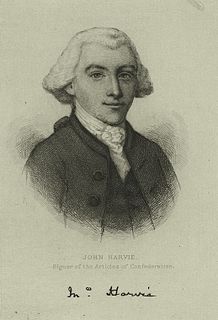
John Harvie was an American Founding Father, lawyer and builder from Virginia. He was a delegate to the Second Continental Congress, where he signed the Articles of Confederation, in 1777 and 1778. He was a successful lawyer and landowner, as well as the fourth mayor of Richmond, Virginia. Thomas Jefferson was a friend since his childhood; his father was Jefferson's guardian. He negotiated a peace treaty in 1774 after the Battle of Point Pleasant. During the American Revolutionary War, he was on the Board of War and operated a prison of war camp on his property, The Barracks.
Peter Jefferson was a planter, cartographer and politician in colonial Virginia best known for being the father of the third president of the United States, Thomas Jefferson. The "Fry-Jefferson Map", created by Peter in collaboration with Joshua Fry in 1757, accurately charted the Allegheny Mountains for the first time and showed the route of "The Great Road from the Yadkin River through Virginia to Philadelphia distant 455 Miles"—what would later come to be known as the Great Wagon Road.

Shadwell is a census-designated place (CDP) in Albemarle County, Virginia, United States, located by the Rivanna River near Charlottesville. The site today is marked by a Virginia Historical Marker to mark the birthplace of President Thomas Jefferson. It is listed on the National Register of Historic Places along with Clifton.

The Rivanna River is a 42.1-mile-long (67.8 km) tributary of the James River in central Virginia in the United States. The Rivanna's tributaries originate in the Blue Ridge Mountains; via the James River, it is part of the watershed of Chesapeake Bay.
This is a list of the National Register of Historic Places listings in Albemarle County, Virginia.
Canada was a small community of free African-Americans established near the University of Virginia in Charlottesville in the 19th century. Many residents of Canada were employed by the university. The community existed from the early 19th century until the early 20th century, by which time the increasingly valuable land had been purchased by white speculators. Researchers theorize that the community was named in homage to the country bordering the United States to the north, where slavery had been abolished under the Slavery Abolition Act of 1833.
StreamWatch is an environmental monitoring program focused on the 766-square-mile (1,980 km2) Rivanna River watershed in central Virginia in the United States. The data StreamWatch collects helps communities in the city of Charlottesville and in Albemarle, Fluvanna, and Greene Counties maintain healthy streams and restore damaged ones. StreamWatch believes that "when diverse sectors of the community share fundamental agreement on the condition of a resource, the chances of sound, collaborative management are enhanced."
Pantops Mountain is a mountain in Albemarle County, Virginia, directly east of Charlottesville across the Rivanna River. and north of U.S. Route 250.

Woolen Mills Village Historic District is a historic district that was listed on the National Register of Historic Places on April 12, 2010. The district is in Albemarle County, Virginia and also in Charlottesville, Virginia.

Riverview Cemetery is a private cemetery located in the Woolen Mills section of Charlottesville, Virginia, at 1701 Chesapeake Street. Founded in 1892 as Charlottesville's two public cemeteries—Maplewood and Oakwood—were filling up, Riverview consists of about 50 acres overlooking a bend in the Rivanna River and has approximately 12,000 graves with room for about 7,000 more.
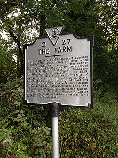
The historic home listed as Lewis Farm, also known as The Farm and John A. G. Davis Farm, is located at Charlottesville, Virginia. It was built in 1826, and is a two-story brick dwelling with a low hipped roof and two large chimneys. On the front facade is a Tuscan order portico with a terrace above. The house was built by individuals who worked with Thomas Jefferson on building the University of Virginia. Its builder, John A. G. Davis, was law professor at the University of Virginia and was shot and killed outside Pavilion X by a student in 1840. During the American Civil War, Brigadier General George Armstrong Custer set up temporary headquarters at the house where he remained for three days.
Jackson P. Burley High School was a segregated school for African American students in Charlottesville, Virginia. Located on Rose Hill Drive, it opened in 1951 to serve students from both the City of Charlottesville and Albemarle County. It graduated its final class of seniors in 1967, and soon after, the City's interest in the school was purchased by Albemarle County. In 1974 it reopened as Jackson P. Burley Middle School.
Albemarle Training School was a segregated school for African American students in Albemarle County, Virginia. It was located north of Charlottesville near what is now the Ivy Creek Reservoir. It was built on the site of the Union Ridge Graded School after that building burned down in 1893. The school served all grades, and is notable for being the first four-year high school for African American students in Albemarle County. In 1951, its students were transferred to the new Burley High School in Charlottesville, and the facility became an elementary school until closing in 1959.

Belmont Plantation, also known as Belmont Estate and Belmont, is a locale in Albemarle County, Virginia, and the site of a 19th-century plantation. It was among the first patents in Albemarle County, patented in the 1730s. Matthew Graves sold a 2,500-acre-tract to John Harvie Sr., a friend of Peter Jefferson and a guardian of Thomas Jefferson. After his death in 1767, the property was inherited by his son John Harvie, Jr. Harvie lived at Belmont for several years, but after he was appointed the Registrar of Land Grants, he moved to Richmond, Virginia and John Rogers oversaw the plantation. Rogers was known for his progressive approaches to agriculture, including methods for improving the quality of the soil after years of tobacco crops.
References
- ↑ "Woolen Mills | City of Charlottesville". www.charlottesville.org. Archived from the original on 2018-04-13. Retrieved 2018-04-12.
- ↑ G, Yackso, Sharon. The Pelican Guide to the Shenandoah: With Sidetrips to Charlottesville and the Alleghenys. Pelican Publishing. ISBN 978-1-4556-1030-3.
- 1 2 Lay, K. Edward (2000). The Architecture of Jefferson Country: Charlottesville and Albemarle County, Virginia. University of Virginia Press. ISBN 978-0-8139-1885-3.
- 1 2 "Charlottesville Woolen Mills". www.historicwoolenmills.org. Retrieved 2018-04-12.
- ↑ "When woolens ruled: The mill behind the neighborhood". www.readthehook.com. Retrieved 2018-04-12.
- ↑ "Woolen Mills revival project takes big step forward ⋅ Charlottesville Tomorrow". Charlottesville Tomorrow. Retrieved 2018-04-12.
Coordinates: 38°01′14″N78°27′22″W / 38.02042869778613°N 78.45619256430989°W