
Comanche County is a county located in the U.S. state of Oklahoma. As of the 2010 census, the population was 124,098, making it the fourth-most populous county in Oklahoma. Its county seat is Lawton. The county was created in 1901 as part of Oklahoma Territory. It was named for the Comanche tribal nation.

Medicine Park is a town in Comanche County, Oklahoma, United States, situated in the Wichita Mountains near the entrance to the 60,000-acre (240 km2) Wichita Mountain Wildlife Refuge. Medicine Park has a long history as a vintage cobblestone resort town. Medicine Park is located near the city of Lawton and Fort Sill. It is an exurb, part of the Lawton Metropolitan Statistical Area. Many of the original structures are constructed of naturally formed cobblestones—these red granite cobblestones are unique to the Wichita Mountains. The population was 382 at the 2010 census.

The Wichita Mountains are located in the southwestern portion of the U.S. state of Oklahoma. It is the principal relief system in the Southern Oklahoma Aulacogen, being the result of a failed continental rift. The mountains are a northwest-southeast trending series of rocky promontories, many capped by 500 million-year old granite. These were exposed and rounded by weathering during the Pennsylvanian & Permian Periods. The eastern end of the mountains offers 1,000 feet (305 m) of topographic relief in a region otherwise dominated by gently rolling grasslands.
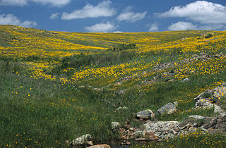
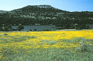
Wichita Mountains Wildlife Refuge, located in southwestern Oklahoma near Lawton, has protected unique wildlife habitats since 1901 and is the oldest managed wildlife facility in the United States Fish and Wildlife Service system. The refuge's location in the geologically unique Wichita Mountains and its areas of undisturbed mixed grass prairie make it an important conservation area. The Wichitas are approximately 500 million years old. Measuring about 59,020 acres (238.8 km2), the refuge hosts a great diversity of species: 806 plant species, 240 species of birds, 36 fish, and 64 reptiles and amphibians are present.

The Cibola National Forest is a 1,633,783 acre United States National Forest in New Mexico, USA. The name Cibola is thought to be the original Zuni Indian name for their pueblos or tribal lands. The name was later interpreted by the Spanish to mean "buffalo." The forest is disjointed with lands spread across central and northern New Mexico, west Texas and Oklahoma. The Cibola National Forest is divided into four Ranger Districts: the Sandia, Mountainair, Mt. Taylor, and Magdalena. The Forest includes the San Mateo, Magdalena, Datil, Bear, Gallina, Manzano, Sandia, Mt. Taylor, and Zuni Mountains of west-central New Mexico. The Forest also manages four National Grasslands that stretch from northeastern New Mexico eastward into the Texas Panhandle and western Oklahoma. The Cibola National Forest and Grassland is administered by Region 3 of the United States Forest Service from offices in Albuquerque, New Mexico. Elevation ranges from 5,000 ft to 11,301 ft. The descending order of Cibola National Forest acres by county are: Socorro, Cibola, McKinley, Catron, Torrance, Bernalillo, Sandoval County, New Mexico, Lincoln, Sierra, and Valencia counties in New Mexico. The Cibola National Forest currently has 137,701 acres designated as Wilderness. In addition to these acres, it has 246,000 acres classified as Inventoried Roadless Areas pursuant to the Roadless Area Conservation Rule.

The National Wildlife Refuge System in the United States has a long and distinguished history.

Lake Ellsworth is a lake in Caddo and Comanche counties in the state of Oklahoma in the United States. It was built by the City of Lawton, Oklahoma in 1962, primarily to serve as a water supply source for Lawton and the surrounding area. The nearest community is Elgin, Oklahoma.
Mount Scott is a prominent mountain just to the northwest of Lawton, Oklahoma rising to a height of 2,464 feet (751 m) and is located in the Wichita Mountains near Fort Sill Military Reservation and lies in the Wichita Mountains National Wildlife Refuge (WMWR). The US Fish and Wildlife Service is responsible for the maintenance of the area. Visitors can reach the summit by car or bicycle via a three-mile paved road. Hiking is allowed, although there are no formal trails and the paved road is open to pedestrians and bicycles from 6am to 9:30 am only. Mount Scott is also popular for its numerous rock climbing areas. The peak was named in honor of General Winfield Scott.

The Geography of Oklahoma encompasses terrain and ecosystems ranging from arid plains to subtropical forests and mountains. Oklahoma contains 10 distinct ecological regions, more per square mile than in any other state by a wide margin. It is situated in the Great Plains and U.S. Interior Highlands region near the geographical center of the 48 contiguous states. Usually considered part of the South Central United States, Oklahoma is bounded on the east by Arkansas and Missouri, on the north by Kansas, on the northwest by Colorado, on the far west by New Mexico, and on the south and near-west by Texas.
The following is an alphabetical list of articles related to the U.S. state of Montana.
Mount Pinchot is the highest peak in the Wichita Mountains Wildlife Refuge of Southwest Oklahoma at 2,476 feet above sea level. It is located toward the western edge of the WMWR. The US Fish and Wildlife Service is responsible for the maintenance of the area. Mount Pinchot is located within the Wildlife Refuge's Special Use Area and is closed to the public. Special wildlife viewing tours are offered by the Refuge which take participants very near the base of the mountain.

Lake Lawtonka is a lake in Comanche County in the state of Oklahoma in the United States. The lake is 2 square miles (5 km2) in area. It is formed by a dam 60 feet (18 m) and 375 feet (114 m) long across Medicine Creek.
Cache Creek is a small creek in Cotton County, Oklahoma and a tributary of the Red River. Cache Creek has a distance of 5.5 miles (8.85 km) from the Red River to the East Cache Creek and West Cache Creek basin. The East Cache Creek and West Cache Creek confluence is located 6 miles (9.75 km) southwest of Temple, Oklahoma.

Washita National Wildlife Refuge is a National Wildlife Refuge (NWR) of the United States located in Custer County, Oklahoma. Created in 1961 on the shore of Foss Lake, it was the fourth NWR in the state. It is 5 miles (8.0 km) west of Butler, Oklahoma.

Elmer Thomas Lake is a lake in Comanche County in the state of Oklahoma in the United States. It is located on the boundary between the Wichita Mountain Wildlife Refuge and Fort Sill military base. The lake is named for an Oklahoma lawyer and politician, Elmer Thomas (1876–1965), who lived in Lawton and represented Oklahoma's 6th Congressional District in the U. S. House of Representatives from 1922 until 1926, then was elected as U.S. Senator, where he served until 1950.

The Central Great Plains are a semiarid prairie ecoregion of the central United States, part of North American Great Plains. The region runs from west-central Texas through west-central Oklahoma, central Kansas, and south-central Nebraska.

Robinsons Landing Marina is located in Comanche County, Oklahoma within the continental United States. Lake Lawtonka provides the fresh water source for the waterfront marina situated in the north shoreline boundaries of the Lawtonka reservoir.

Ketch Ranch House or Ketch Ranch was private property located in the Wichita Mountains of Southwestern Oklahoma. The ranch was established as a working ranch and vacation home for Ada May Ketch and Frank Levant Ketch during the early 1920s. The Wichita Mountain ranch offered a guest house, barn, smokehouse, springhouse, and root cellar while providing outdoor experiences with horseback riding, boating, and fishing at Ketch Lake which was close proximity of 1 mile (1.6 km) from the Ketch Ranch House.

