Charter Stones

Last updated

The Old Dailly Charter Stone is the larger of the two. The Blue Stones of Dailly - geograph.org.uk - 1500376.jpg
The Old Dailly Charter Stone is the larger of the two.

Charter Stones are large stone monuments that date back to ancient times when such stones were granted to individuals or communities in lieu of written charters to signify the granting of land by the crown, feudal overlords or other individuals. [1] They were used to record ownership of land before written documents came into general use. [2]

Contents

Characteristics of Charter Stones

The stones were sometimes engraved or were instead distinctive in terms of colour, composition or shape. The use of these stones may relate to the common practice of using boundary stones to establish precise limits to areas of land ownership [3] but differ in that the proof of the land ownership was invested in them. Being stone they had a permanence that gave them an advantage over charters written on vellum, etc. An essential element was that the stone in question had once belonged to the donor and was next held by the grantee. [4] The size, weight and individuality of charter stones helped to ensure that they were not easily stolen or moved any significant distance.

Surviving examples

The Kilnasaggart Charter Stone. Kilnasaggart inscribed stone County Armagh 1.jpg
The Kilnasaggart Charter Stone.
Replica of the Stone of Scone. Stone of scone replica 170609.jpg
Replica of the Stone of Scone.

In Old Dailly a tradition has it that when worship was discontinued at the old kirk in 1695 the people of Dailly insisted that the 'Blue stone' or charter stone should be removed from the old kirk to the new parish church. The people of Old Dailly refused to part with their ancient stone and in his historical notes located in Sir Walter Scott’s “Lord of The Isles”, he records this conflict in Dailly parish and notes that it was settled ‘when man, woman and child from both communities marched out and by one desperate engagement put an end to the conflict’. The inhabitants of Old Dailly triumphed and the 'Blue Stone' still resides in the old churchyard. Old Dailly is sometimes recorded as the 'Blue Stone Burgh'. [5] Smith in 1895 mentions charter stones plural and suggests that the tradition of trials of strength, in common with the 'Leper's Charter Stone' at Prestwick, was linked with proof that the person granted the land involved was mature enough to hold it. [6]

At the Bruce's Well, Kingcase in Prestwick, records describe the Lepers' Charter Stone as being the shape of a sheep's kidney, formed of basalt, blue in colour and as smooth as glass. It weighed around 15 stones or 95 Kilograms and its weight was such that it could only be lifted with arms extended and cupped in a cavity in the stone. Lifting it was considered proof of the passage to manhood. [7] Sources state that some English dragoons encamped one night at Bruce's Well where the charter stone was kept and somehow managed to break it. The pieces were collected and carefully kept by the freemen of Prestwick [8] and later incorporated into the consolidated walls of the old St Ninian's Chapel (see video). Another source states that "... a low character of the name of Allison, who rented a salt-pan in the neighbourhood, about the year 1800 bribed a drunk man, who broke the stone in pieces." [9]

The Old Inverness Market cross and Clach na Cudainn Charter Stone Old Market cross and Clach na Cudainn - geograph.org.uk - 548602.jpg
The Old Inverness Market cross and Clach na Cudainn Charter Stone
The London Stone LondonStone.jpg
The London Stone

The Clach na Cudainn (Gaelic for 'stone of the tub') or Charter Stone of Inverness was kept in the market place, set in a frame and bound with iron. [10] Also known as the Clachnacuddin Stone it is said that as long as the stone is preserved then Inverness will flourish. The upper surface was supposedly worn flat by the action of women resting their tubs or pails on it whilst they rested. [11]

Near Blair Atholl at Pitagowan in Perthshire the Clach na h-Iobairt (the stone of offering) or 'Bridge of Tilt' standing stone is said to be a charter stone that records a land grant, possibly to the Church of Kilmaveonaig. [12] [13]

The Stone of Scone was regarded as being the charter stone of the Kingdom of Scotland. [14]

In Wales charter stones are recorded from Llanllyr in Merioneth (circa 8th century) and Merthyr Mawr (11th century) and Ogmore (11th century) in Glamorgan. [15] The example at Merthyr Mawr carries the inscription "in grefium in propium" which translates literally as "ownership was registered" [16] and commemorates St Glywys. [17] The Ogmore charter stone also honours St Glywys and records a Bishop Fili who was the grantee of an ager, a field. [18]

In England the ancient London Stone has been put forward as a charter stone due to its proximity to lands once held by Canterbury Cathedral. [19] The Kirkby Stephen charter stone in Cumbria is till used on St Luke’s Fair day in October for the reading of the market's charter. [20] Also in Cumbria is the Ca'an Stone in the main street of Kendal, once part of the market cross, but possibly older and once used as a place where proclamations were read. [21]

A possible example has been recorded at Stoke near Hartland in North Devon. [22]

In Ireland's County Armagh an eighth century example of a charter stone is recorded at Kilnasaggart. [23]

In the Isle of Man it is recorded that it was common for charter stones to be given as a sign of transfer of ownership, the stone itself once having been the property of the donor. [24]

Micro-history

The Kendal Ca' Stone The Ca' Steean or Stone, Kendal, Cumbria.jpg
The Kendal Ca' Stone

Records show that before the Norman conquest other items that once belonged to the donor of property were given in lieu of a written charter, such as swords, helmets and especially horns. [25]

Tradition has it that charter stones are sometimes possessed with special powers such as bringing good luck to those who touch them and in some cases they can supposedly cure certain illness, etc. [26] The Old Dailly stone is said to have held the right of being a sanctuary stone. [27]

The larger of the two Old Dailly charter stones weighs between 20 and 23 stone (130 and 150 kg) and the smaller between 18.5 and 20 stone (117 and 127 kg) and like the old Lepers' charter stone at Prestwick is smooth and their shape make them difficult to grip them easily and over the years they became a weight lifting challenge. In international stone lifting circles the name The Big Blue was the name given to the largest Old Dailly stone as a ‘lifting’ or ‘testing’ stone however the local council have bound both with metal hoops and they cannot at present be lifted. [28]

See also

Related Research Articles

<span class="mw-page-title-main">Walter Scott</span> Scottish novelist, poet and playwright (1771–1832)

Sir Walter Scott, 1st Baronet, was a Scottish novelist, poet, playwright and historian. Many of his works remain classics of European and Scottish literature, notably the novels Ivanhoe, Rob Roy, Waverley, Old Mortality, The Heart of Mid-Lothian and The Bride of Lammermoor, and the narrative poems The Lady of the Lake and Marmion. He had a major impact on European and American literature.

<span class="mw-page-title-main">Ayrshire</span> Historic county in Scotland

Ayrshire is a historic county and registration county in south-west Scotland, located on the shores of the Firth of Clyde. Its principal towns include Ayr, Kilmarnock and Irvine and it borders the counties of Renfrewshire and Lanarkshire to the north-east, Dumfriesshire to the south-east, and Kirkcudbrightshire and Wigtownshire to the south. Like many other counties of Scotland it currently has no administrative function, instead being sub-divided into the council areas of North Ayrshire, South Ayrshire and East Ayrshire. It has a population of approximately 366,800.

<span class="mw-page-title-main">Westmorland</span> Historic county of England

Westmorland (, formerly also spelt Westmoreland; is a historic county in North West England spanning the southern Lake District and the northern Dales. It had an administrative function from the 12th century until 1974. Between 1974 and 2023 Westmorland lay within the administrative county of Cumbria. In April 2023, Cumbria County Council will be abolished and replaced with two unitary authorities, one of which, Westmorland and Furness, will cover all of Westmorland, thereby restoring the Westmorland name to a top-tier administrative entity. The people of Westmorland are known as Westmerians.

<span class="mw-page-title-main">Isle of Sheppey</span> Island off the coast of Kent, England

The Isle of Sheppey is an island off the northern coast of Kent, England, neighbouring the Thames Estuary, centred 42 miles (68 km) from central London. It has an area of 36 square miles (93 km2). The island forms part of the local government district of Swale. Sheppey is derived from Old English Sceapig, meaning "Sheep Island".

<span class="mw-page-title-main">Spilsby</span> Market town and civil parish in Lincolnshire, England

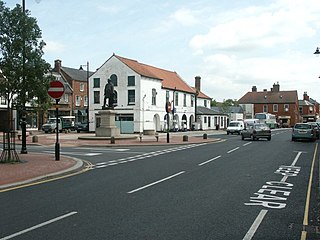
Spilsby is a market town, civil parish and electoral ward in the East Lindsey district of Lincolnshire, England. The town is adjacent to the main A16, 33 miles (53 km) east of the county town of Lincoln, 17 miles (27 km) north-east of Boston and 13 miles (21 km) north-west of Skegness. It lies at the southern edge of the Lincolnshire Wolds and north of the Fenlands, and is surrounded by scenic walking, nature reserves and other places to visit.

<span class="mw-page-title-main">Pictish stone</span> Monuments erected by early Scottish tribes

A Pictish stone is a type of monumental stele, generally carved or incised with symbols or designs. A few have ogham inscriptions. Located in Scotland, mostly north of the Clyde-Forth line and on the Eastern side of the country, these stones are the most visible remaining evidence of the Picts and are thought to date from the 6th to 9th century, a period during which the Picts became Christianized. The earlier stones have no parallels from the rest of the British Isles, but the later forms are variations within a wider Insular tradition of monumental stones such as high crosses. About 350 objects classified as Pictish stones have survived, the earlier examples of which holding by far the greatest number of surviving examples of the mysterious symbols, which have long intrigued scholars.

<span class="mw-page-title-main">Archdiocese of Glasgow</span> Diocese of the Scottish church

The Archdiocese of Glasgow was one of the thirteen dioceses of the Scottish church. It was the second largest diocese in the Kingdom of Scotland, including Clydesdale, Teviotdale, parts of Tweeddale, Liddesdale, Annandale, Nithsdale, Cunninghame, Kyle, and Strathgryfe, as well as Lennox, Carrick and the part of Galloway known as Desnes.

<span class="mw-page-title-main">Carloway</span> Human settlement in Scotland

Carloway is a crofting township and a district on the west coast of the Isle of Lewis, in the Outer Hebrides, Scotland. The district has a population of around 500. Carloway township is within the parish of Uig, and is situated on the A858.

<span class="mw-page-title-main">Breamore</span> Human settlement in England

Breamore is a village and civil parish near Fordingbridge in Hampshire, England. The parish includes a notable Elizabethan country house, Breamore House, built with an E-shaped ground plan. The Church of England parish church of Saint Mary has an Anglo-Saxon rood.

<span class="mw-page-title-main">Lifting stone</span> Heavy natural stone lifted by people in strength competitions

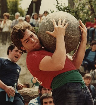
Lifting stones are heavy natural stones which people are challenged to lift, proving their strength. They are common throughout northern Europe, particularly Scotland, Wales, Iceland, Scandinavia and North West England centred around Cumbria.

<span class="mw-page-title-main">John Thomson of Duddingston</span>

Rev John Thomson FRSE HonRSA was a Scottish minister of the Church of Scotland and noted amateur landscape painter. He was the minister of Duddingston Kirk from 1805 to 1840.

<span class="mw-page-title-main">Clach an Tiompain</span>

Clach an Tiompain or The Eagle Stone is a small Class I Pictish stone located on a hill on the northern outskirts of Strathpeffer in Easter Ross, Scotland.

<span class="mw-page-title-main">Liberton, Edinburgh</span> Human settlement in Scotland

Liberton is a suburb of Edinburgh, the capital of Scotland. It is in the south of the city, south of The Inch, east of the Braid Hills, north of Gracemount and west of Moredun.

<span class="mw-page-title-main">Kirby Hill, Harrogate</span> Village and civil parish in North Yorkshire, England

Kirby Hill, also called Kirby-on-the-Moor, is a village and civil parish about 1 mile (1.6 km) north of the market town of Boroughbridge, in the Harrogate district of North Yorkshire, England.

<span class="mw-page-title-main">History of the Outer Hebrides</span>

The Hebrides were settled early on in the settlement of the British Isles, perhaps as early as the Mesolithic era, around 8500–8250 BC, after the climatic conditions improved enough to sustain human settlement. There are examples of structures possibly dating from up to 3000 BC, the finest example being the standing stones at Callanish, but some archaeologists date the site as Bronze Age. Little is known of the people who settled in the Hebrides but they were likely of the same Celtic stock that had settled in the rest of Scotland. Settlements at Northton, Harris, have both Beaker & Neolithic dwelling houses, the oldest in the Western Isles, attesting to the settlement.

<span class="mw-page-title-main">Craigie Castle</span>

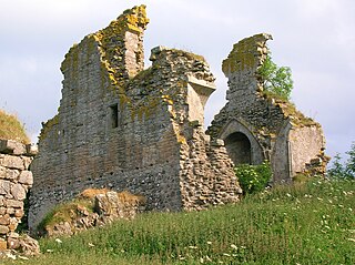
Craigie Castle, in the old Barony of Craigie, is a ruined fortification situated about 4 miles (6.4 km) southeast of Kilmarnock and 1 mile (1.6 km) southeast of Craigie village, in the Civil Parish of Craigie, South Ayrshire, Scotland. The castle is recognised as one of the earliest buildings in the county. It lies about 1.25 miles (2 km) west-south-west of Craigie church. Craigie Castle is protected as a scheduled monument.

<span class="mw-page-title-main">Loans, South Ayrshire</span> Human settlement in Scotland

Loans is a village in South Ayrshire near Troon, Scotland. It is located in Dundonald parish on the A759 at the junction with the B746 and a minor road to Dundonald.

<span class="mw-page-title-main">Hospitals in medieval Scotland</span>

Hospitals in medieval Scotland can be dated back to the 12th century. From c. 1144 to about 1650 many hospitals, bedehouses and maisons Dieu were built in Scotland.

<span class="mw-page-title-main">Ninestane Rig</span>

Ninestane Rig is a small stone circle in Scotland near the English border. Located in Roxburghshire, near to Hermitage Castle, it was probably made between 2000 BC and 1250 BC, during the Late Neolithic or early Bronze Age. It is a scheduled monument and is part of a group with two other nearby ancient sites, these being Buck Stone standing stone and another standing stone at Greystone Hill. Settlements appear to have developed in the vicinity of these earlier ritual features in late prehistory and probably earlier.

Walter Scott's "Memoirs", first published as "Memoir of the Early Life of Sir Walter Scott, Written by Himself" and also known as the Ashestiel fragment, is a short autobiographical work describing the author's ancestry, parentage, and life up to the age of 22. It is the most important source of information we have on Scott's early life. It was mainly written between 1808 and 1811, then revised and completed in 1826, and first published posthumously in 1837 as Chapter 1 of J. G. Lockhart's multi-volume Memoirs of the Life of Sir Walter Scott, Bart. It was re-edited in 1981 by David Hewitt.

References

  1. "Dailly Parish Community Website" . Retrieved 23 May 2017.
  2. Scott, Sir Walter (1826). Poetical Works.
  3. Pryce, Huw (1998). Literacy in Medieval Celtic Societies. Cambridge University Press. ISBN   0-521-57039-5.
  4. Train, Joseph (1845). An Historical and Statistical Account of the Isle of Man: From the ..., Volume 1. Mary A Quiggin. p. ii.
  5. "Dailly Parish Community Website" . Retrieved 23 May 2017.
  6. Smith, John (1895). Prehistoric Man In Ayrshire. Elliot Stock. p. 207.
  7. Scott, Sir Walter (1826). Poetical Works.
  8. Scott, Sir Walter (1826). Poetical Works.
  9. "Glasgow Broadside Ballads" . Retrieved 24 May 2017.[ permanent dead link ]
  10. Scott, Sir Walter (1826). Poetical Works.
  11. "Merkat Cross and Clachnacuddin Stone outside Town House of Inverness, Scotland". Flickr. Retrieved 24 May 2017.
  12. Pryce, Huw (1998). Literacy in Medieval Celtic Societies. Cambridge University Press. ISBN   0-521-57039-5.
  13. "RCAHMS Canmore - Clach Na H' Iobairt" . Retrieved 23 May 2017.
  14. Scott, Sir Walter (1826). Poetical Works.
  15. Williams, Howard (2003). Archaeologies of Remembrance: Death and Memory in Past Societies. Springer Science & Business Media New York. ISBN   978-1-4613-4845-0.
  16. Pryce, Huw (1998). Literacy in Medieval Celtic Societies. Cambridge University Press. ISBN   0-521-57039-5.
  17. Davies, John Reuben (2003). The Book of Llandaf and the Norman Church in Wales. Boydell Press. ISBN   1-84383-024-8.
  18. Davies, John Reuben (2003). The Book of Llandaf and the Norman Church in Wales. Boydell Press. ISBN   1-84383-024-8.
  19. The Literary Panorama and National Register, Volume 2. 1815. p. 291.
  20. "A Short History of Kirkby Stephen". Kirkby Stephen Community Council. Retrieved 24 May 2017.
  21. Holloway, Norman (2013). Kendal Through Time. Amberley Books. ISBN   978-1-4456-2901-8.
  22. Williams, Howard (2003). Archaeologies of Remembrance: Death and Memory in Past Societies. Springer Science & Business Media New York. ISBN   978-1-4613-4845-0.
  23. Williams, Howard (2003). Archaeologies of Remembrance: Death and Memory in Past Societies. Springer Science & Business Media New York. ISBN   978-1-4613-4845-0.
  24. Train, Joseph (1845). An Historical and Statistical Account of the Isle of Man: From the ..., Volume 1. Mary A Quiggin. p. ii.
  25. Train, Joseph (1845). An Historical and Statistical Account of the Isle of Man: From the ..., Volume 1. Mary A Quiggin. p. ii.
  26. "Dailly Parish Community Website" . Retrieved 23 May 2017.
  27. "History of Dailly". Wiki. Retrieved 24 May 2017.
  28. "Dailly Parish Community Website" . Retrieved 23 May 2017.