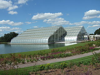
Wisley is a village and civil parish in Surrey, England between Cobham and Woking, in the Borough of Guildford. It is the home of the Royal Horticultural Society's Wisley Garden. The River Wey runs through the village and Ockham and Wisley Commons form a large proportion of the parish on a high acid heathland, which is a rare soil type providing for its own types of habitat. It has a standard weather monitoring station, which has recorded some national record high temperatures.

Ockham is a rural and semi-rural village in the borough of Guildford in Surrey, England. The village starts immediately east of the A3 but the lands extend to the River Wey in the west where it has a large mill-house. Ockham is between Cobham and East Horsley.

Surrey Heath is a local government district with borough status in Surrey, England. Its council is based in Camberley. Much of the area is within the Metropolitan Green Belt.

Elmbridge is a local government district with borough status in Surrey, England. Its principal towns and villages are Esher, Cobham, Walton-on-Thames, Weybridge and Molesey. It directly borders the London Borough of Richmond upon Thames and the London Royal Borough of Kingston upon Thames. Some areas of the borough form a continuation of the Greater London Built-up Area, formerly falling into the Metropolitan Police District.

Surrey Wildlife Trust (SWT) was founded in 1959 as Surrey Naturalists' Trust and it is one of forty-six wildlife trusts covering Great Britain, Northern Ireland, Isle of Man and Alderney. SWT carries out conservation activities on a considerable area of Surrey County Council's large countryside estate and also manages land on behalf of the Ministry of Defence estate. As of 2022 the SWT manages more than 6,000 hectares of land for wildlife and employs more than 100 staff. It had an income of £5.1 million and expenditure of £5.7 million.

Witley Common is an area of woodland and heath, close to Witley, Surrey, in the United Kingdom. It is part of a much larger Site of Special Scientific Interest.
The Landmark Trust is a British building conservation charity, founded in 1965 by Sir John and Lady Smith, that rescues buildings of historic interest or architectural merit and then makes them available for holiday rental. The Trust's headquarters is at Shottesbrooke in Berkshire.
Downside is a small village in the English county of Surrey, in the local government district of Elmbridge, centred on Downside Common which is 18 miles (29 km) southwest of London and 8.4 miles (13.5 km) northeast of Guildford. Most of its buildings form a cluster. It has an inn, Downside Sports and Social Club, regular village hall events and an annual sports day. It is in the Cobham and Downside ward of Elmbridge Borough Council.

Ockham and Wisley Commons is a 266-hectare (660-acre) biological Site of Special Scientific Interest east of Woking in Surrey. It is also a Local Nature Reserve and part of the Thames Basin Heaths Special Protection Area. It is part of the slightly larger area of 297-hectare (730-acre) Wisley & Ockham Commons & Chatley Heath nature reserve, which is owned by Surrey County Council and managed by the Surrey Wildlife Trust.

Hatchford is a hamlet in the English county of Surrey outside the town of Cobham ; it traditionally includes the contiguous hamlet of Pointers Green.

Burner's Heath and Swallows Pond is a 5-hectare (12-acre) nature reserve in Pirbright in Surrey. It is owned by Surrey County Council and managed by the Surrey Wildlife Trust.

Bisley and West End Commons is a 37.2-hectare (92-acre) Local Nature Reserve west of Woking in Surrey. It is part of the 46-hectare (110-acre) Bisley & West End Commons and Reidon Hill nature reserve, which is owned by Surrey County Council and managed by Surrey Wildlife Trust. The site is also part of the Colony Bog and Bagshot Heath Site of Special Scientific Interest, the Thursley, Ash, Pirbright & Chobham Special Area of Conservation and the Thames Basin Heaths Special Protection Area,

Brentmoor Heath is a 28.6-hectare (71-acre) Local Nature Reserve east of Camberley in Surrey. It is part of Brentmoor Heath and Folly Bog nature reserve, the ownership of which is divided between the Ministry of Defence, Surrey County Council and Surrey Heath Borough Council, and is managed by Surrey Wildlife Trust. The site is also part of Colony Bog and Bagshot Heath site of Special Scientific Interest, Thursley, Ash, Pirbright & Chobham Special Area of Conservation and Thames Basin Heaths Special Protection Area.

Chinthurst Hill is a 17.2-hectare (43-acre) Local Nature Reserve south of Guildford in Surrey. It is owned by Surrey County Council and managed by Surrey Wildlife Trust. Chinthurst Hill Tower is a Grade II Scheduled Monument.

Rodborough Common is a 62.2-hectare (154-acre) Local Nature Reserve west of Milford in Surrey. It is owned by Surrey County Council and managed by Surrey Wildlife Trust.

Crooksbury Hill is a 17.2-hectare (43-acre) nature reserve within Puttenham and Crooksbury Commons east of Farnham in Surrey. It is owned by Surrey County Council and managed by the Surrey Wildlife Trust. Soldier's Ring on the north side of the hill is a Scheduled Monument. It is a hillfort dating to the late Bronze Age or early Iron Age.

Littlefield Common is a 17-hectare (42-acre) nature reserve south-west of Worplesdon in Surrey. It is owned by Surrey County Council and managed by the Surrey Wildlife Trust.

Stringer's Common is a 30-hectare (74-acre) nature reserve east of Worplesdon in Surrey. It is owned by Surrey County Council and managed by the Surrey Wildlife Trust.
