
Guruvayur is a municipal temple town in Thrissur district, of Kerala State in India. It is a suburban town of Thrissur city, located 27 kilometres (17 mi) from Thrissur towards the north-west. It houses the Guruvayur Shri Krishna Temple. It is located at a distance of 292 km (181 mi) from the state capital Trivandrum towards the north-west, 80 km (50 mi) from Kochi towards the north, 90 km (56 mi) from Calicut towards south.

Kodaikanal is a hill station which is located in Dindigul district in the state of Tamil Nadu, India. Its name in the Tamil language means "The Gift of the Forest". Kodaikanal is referred to as the "Princess of Hills" and has a long history as a retreat and tourist destination.
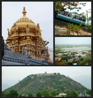
Palani (Tamil:[paɻani] or Palnias in British records, is a town and a taluk headquarters in Dindigul district of the western part of Tamil Nadu state in India. It is located about 106 kilometres south-east of Coimbatore and 122 kilometres north-west of Madurai, 67 kilometres from Kodaikanal. The Palani Murugan Temple or Arulmigu Dhandayuthapani Swamy Temple, dedicated to Murugan is situated on a hill overlooking the town. The temple is visited by more than 7 million pilgrims each year. As of 2011, the town had a population of 292301 which makes it the second largest town in the district after Dindigul.

Rayavaram is a village Panchayat in Pudukkottai district in Tamil Nadu, India.

Tirunelveli district is one of the 38 districts of Tamil Nadu state in India. It is the largest district in terms of area with Tirunelveli as its headquarters. The district was formed on 1 September 1790 by the British East India Company, and comprised the present Tirunelveli and Thoothukudi, Tenkasi and parts of Virudhunagar and Ramanathapuram district. As of 2011, the undivided district had a population of 3,077,233.

Parippally is a village in Kalluvathukal Panchayath of Kollam district, Kerala, India. Paripally village is situated 22 kilometres (14 mi) South of Kollam City along NH66 and 44 kilometres (27 mi) North of Trivandrum along NH66. Kollam Govt. Medical College is situated in Parippally. The nearest town Chathannor is located 3 kilometres (1.9 mi) away, Kottiyam is another major town located near Parippally.
Sholavandan is a panchayat town in Madurai district in the Indian state of Tamil Nadu. It is located on the left bank of the Vaigai River, sixteen miles north west of Madurai. It is one of 12 "town- panchayats" of Madurai district.

Thiruparankundram, also spelled Tirupparankundram or Tiruparangundram, is a neighbourhood in Madurai city in Tamil Nadu, India. It is about 7 kilometres (4.3 mi) from Periyar Bus Terminus, the centre of the city and constitutes the southwest part of the Madurai city. The town's landmark and fame is the huge monolithic rock hill that towers to a height of 1,048 feet (319 m) and has a circumference of over 2 miles (3.2 km). It is a home to many ancient and historic monuments including Jain caves, some protected as India's national monuments.

Lakshmipuram (L.Pudhupatti) is a village in south Tamil Nadu, India. It is situated at the foothills of the Western Ghats, 9 kilometres (5.6 mi) from the city of Theni. It is 7 kilometres (4.3 mi) from Periyakulam on NH 183. The population of this village is over 10,000.
Pasuvanthanai also spelt as Passuvandanai is a panchayat village in Ottapidaram Taluk in Thoothukudi district in the Indian state of Tamil Nadu.

Thiruvedagam is a village located in between Sholavandan and Madurai. It is 18 kilometres away from Madurai and 3 kilometres away from Sholavandan. It comes under Vadipatti taluk in Madurai district. It is located at the bank of the River Vaigai, which flows in the direction North to South here in Thiruvedagam. Here a famous and historical Shiva temple named Edaganathar temple is located.
Veeravanoor is a village in Ramanathapuram District in the Indian state of Tamil Nadu.
Madurai District was one of the districts of the Madras Presidency of British India. It covered the present-day districts of Madurai, Dindigul, Theni, Ramanathapuram, Sivagangai and parts of Virudhunagar District in the Indian state of Tamil Nadu.
Semmanipatti, also called Semminipatti or Chemminipatti, is a village in the Indian state of Tamil Nadu. Situated at a distance of 29 kilometres (18 mi) North of Madurai and 3 kilometres (1.9 mi) south of Vadipatti on the National Highway.

Keezhavazhavu is a village in Madurai district of Tamil Nadu, India. It is located 43 kilometres (27 mi) from Madurai. It is known for two hillocks called Panchapandavar Malai or Panchapandavar Padukkai which contains ancient Jain sculptures and stone beds, and another is Sakkarai peer oliulla Mountain. It has a cave.
Alagankulam is a village situated on the east coast in the Ramanathapuram taluk and district in India. The village is situated on the banks of the Vaigai River and is about 3 kilometres (1.9 mi) away from the seashore. The village is located 18 kilometres (11 mi) east of Ramanathapuram. The village had a population of 15,473 at the 2011 census.

Tenkasi Junction railway station is a junction railway station serving the town of Tenkasi in the Indian state of Tamil Nadu. The station is a part of the Madurai railway division of the Southern Railway zone. It is the junction point for Virudhunagar and Tirunelveli rail routes.

Rajapalayam railway station is a railway station serving the town of Rajapalayam in Tamil Nadu, India. This station opened on 30.06.1927 along with Virudhunagar jn - Tenkasi Jn as Metre Gauge railway station. early 2000 this section closed for gauge conversion and reopened as BG version of Virudhunagar Jn - Rajapalayam section opened for Traffic on 2003. The station is a part of the Madurai railway division of the Southern Railway zone and connects the city to various parts of the state as well as the rest of the country.
Sholavandan railway station, situated in the Southern Railway zone, is an Indian train station in Vadipatti taluk, a taluk in the Madurai district of Tamil Nadu. The station code is SDN.
Venkatachalapuram is a small village situated in Theni District, Tamil Nadu, India and with direct road connectivity to Theni and Odaipatti. The district headquarters, Theni, is situated 11 kilometres (6.8 mi) north of this village.