Thuja is a genus of coniferous tree or shrub in the Cupressaceae. There are five species in the genus, two native to North America and three native to eastern Asia. The genus is monophyletic and sister to Thujopsis. Members are commonly known as arborvitaes, thujas or cedars.
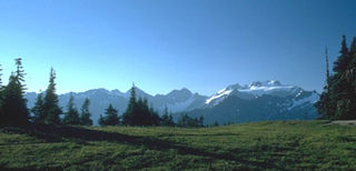
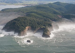
The Olympic Mountains are a mountain range on the Olympic Peninsula of the Pacific Northwest of the United States. The mountains, part of the Pacific Coast Ranges, are not especially high – Mount Olympus is the highest summit at 7,980 ft (2,432 m); however, the eastern slopes rise precipitously out of Puget Sound from sea level, and the western slopes are separated from the Pacific Ocean by the low-lying 20 to 35 km wide Pacific Ocean coastal plain. These densely forested western slopes are the wettest place in the 48 contiguous states. Most of the mountains are protected within the bounds of Olympic National Park and adjoining segments of the Olympic National Forest.

Pacific Rim National Park Reserve is a 511 km2 (197 sq mi) national park located in British Columbia, Canada, which comprises three separate regions: Long Beach, the Broken Group Islands, and the West Coast Trail. It is located in the Pacific Coast Mountains, which are characterized by rugged coasts and temperate rainforests.

Callitropsis nootkatensis, formerly known as Cupressus nootkatensis, is a species of tree in the cypress family native to the coastal regions of northwestern North America. This species goes by many common names including: Nootka cypress, yellow cypress, Alaska cypress, Nootka cedar, yellow cedar, Alaska cedar, and Alaska yellow cedar. The specific epithet nootkatensis is derived from the species being from the area of Nootka Sound on the west coast of Vancouver Island, Canada. Both locations are named for the older European name Nootka, given the Nuu-chah-nulth First Nation.

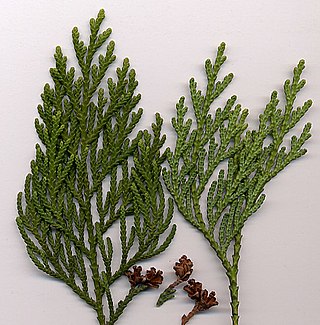
Thuja plicata is a large evergreen coniferous tree in the family Cupressaceae, native to the Pacific Northwest of North America. Its common name is western redcedar in the U.S. or western red cedar in the UK, and it is also called pacific red cedar, giant arborvitae, western arborvitae, just cedar, giant cedar, or shinglewood. It is not a true cedar of the genus Cedrus. T. plicata is the largest species in the genus Thuja, growing up to 70 metres (230 ft) tall and 7 m (23 ft) in diameter. It mostly grows in areas that experience a mild climate with plentiful rainfall, although it is sometimes present in drier areas on sites where water is available year-round, such as wet valley bottoms and mountain streamsides. The species is shade-tolerant and able to establish in forest understories and is thus considered a climax species. It is a very long-lived tree, with some specimens reaching ages of well over 1,000 years.

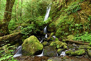
The Pacific temperate rainforests of western North America is the largest temperate rain forest region on the planet as defined by the World Wildlife Fund. The Pacific temperate rainforests lie along the western side of the Pacific Coast Ranges along the Pacific Northwest Coast of North America from the Prince William Sound in Alaska through the British Columbia Coast to Northern California, and are part of the Nearctic realm, as also defined by the World Wildlife Fund. The Pacific temperate rain forests are characterized by a high amount of rainfall, in some areas more than 300 cm (10 ft) per year and moderate temperatures in both the summer and winter months.
The Quinault Rain Forest is a temperate rain forest, which is part of the Olympic National Park and the Olympic National Forest in the U.S. state of Washington in Grays Harbor and Jefferson Counties. The rain forest is located in the valley formed by the Quinault River and Lake Quinault. The valley is called the "Valley of the Rain Forest Giants" because of the number of record size tree species located there. The largest specimens of Western Red Cedar, Sitka Spruce, Western Hemlock, Alaskan Cedar and Mountain Hemlock are found in the forest as well as five of the ten largest Douglas-firs. The forest receives an average of 17 feet (5.2 m) of rain per year. It is believed to be the area with the greatest number of record size giant tree species in the smallest area in the world. It does have the largest trees in the world outside of the state of California and New Zealand.

Carmanah Walbran Provincial Park, originally Carmanah Pacific Provincial Park, is a remote wilderness park located inside traditional Ditidaht First Nation ancestral territory. The park covers a land area of 16,450 ha (63.5 sq mi) immediately adjacent to Pacific Rim National Park Reserve's West Coast Trail on the south-western, coastal terrain of Vancouver Island. The provincial park comprises the entire drainage of Carmanah Creek, and a good portion of the lower Walbran River drainage, both of which independently empty into the Pacific Ocean. The park is named after the Anglicized diitiid?aatx word kwaabaaduw7aa7tx, or Carmanah, meaning "thus far upstream" and John Thomas Walbran, a colonial explorer and ship's captain. Access to the park is by gravel logging road from Port Alberni, Lake Cowichan, or Port Renfrew.
ȽÁU,WELṈEW̱/John Dean Provincial Park, formerly John Dean Provincial Park, is a small, densely vegetated provincial park on the Saanich Peninsula of southern Vancouver Island, British Columbia, Canada. The park is located on and around ȽÁU,WELṈEW̱, a small mountain in the traditional territory of Wsanec First Nations, itself situated 20 km north of Victoria, the provincial capital city.
British Columbia mainland coastal forests is a temperate coniferous forest ecoregion the Pacific coast of North America, as defined by the World Wildlife Fund (WWF) categorization system.

Cedar is a small community in the Canadian province of British Columbia. It is located near the east coast of Vancouver Island — about 8 kilometres (5.0 mi) south-east of Nanaimo — along the banks of the Nanaimo River. Its geographical coordinates are 49°07′N123°51′W.

Lighthouse Park is a neighbourhood park located in a residential area in West Vancouver, Canada. It is a popular tourist attraction for visitors to Vancouver as it is a National Historic Site of Canada. It is a well-maintained park, and is open year-round throughout all four seasons. The park is known for the Point Atkinson Lighthouse, located at the southernmost tip of the peninsula. The park is made up of 75 hectares of mostly virgin rainforest, and was founded in 1792. The District of West Vancouver maintains and operates the park and permits visitors from 7:00 a.m. to 10:00 p.m. Visitors to this park can enjoy the various beginner level hiking trails, as well as bring their dogs for a walk or have lunch along the rocks of the beach near the Lighthouse. There are various picnic benches scattered throughout the trails of the park, yet none near the beach and the lighthouse itself.

Didymascella thujina is an ascomycete fungus in the family Helotiaceae. D. thujina causes cedar leaf blight, a leaf disease, on western red cedar and white cedar (T. occidentalis).

Salmo-Priest Wilderness is a 41,335 acre (167.28 km2) wilderness area located in the Selkirk Mountains in the northeast corner of Washington state, within the Colville National Forest and the Kaniksu National Forest.
The Central Pacific coastal forests is a temperate coniferous forest ecoregion located in the Canadian province of British Columbia and the U.S. states of Oregon and Washington, as defined by the World Wildlife Fund (WWF) categorization system.

The North Central Rockies forests is a temperate coniferous forest ecoregion of Canada and the United States. This region overlaps in large part with the North American inland temperate rainforest and gets more rain on average than the South Central Rockies forests and is notable for containing the only inland populations of many species from the Pacific coast.

Pseudotsuga menziesii var. menziesii, commonly known as Coast Douglas-fir, Pacific Douglas-fir, Oregon pine, or Douglas spruce, is an evergreen conifer native to western North America from west-central British Columbia, Canada southward to central California, United States. In Oregon and Washington its range is continuous from the Cascades crest west to the Pacific Coast Ranges and Pacific Ocean. In California, it is found in the Klamath and California Coast Ranges as far south as the Santa Lucia Mountains with a small stand as far south as the Purisima Hills, Santa Barbara County. In the Sierra Nevada it ranges as far south as the Yosemite region. It occurs from near sea level along the coast to 1,800 metres (5,900 ft) in the California Mountains. Further inland, coast Douglas-fir is replaced by Rocky Mountain or interior Douglas-fir. Interior Douglas-fir intergrades with coast Douglas-fir in the Cascades of northern Washington and southern British Columbia.
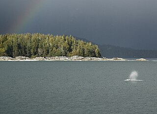
Clayoquot Sound Biosphere Reserve is a UNESCO Biosphere Reserve situated in Clayoquot Sound on the west coast of Vancouver Island in British Columbia, Canada. A diverse range of ecosystems exist within the biosphere reserve boundaries, including temperate coastal rainforest, ocean and rocky coastal shores.

The San Juan Valley is a small valley located in the Capital Regional District of Vancouver Island in British Columbia, Canada.

The Duncan Cedar, also known as the Duncan Memorial Cedar and the Nolan Creek Tree, is a large specimen of Western redcedar. The tree is located on the Olympic Peninsula in the U.S. state of Washington. It is currently the largest known Western redcedar in the world, (compare to the Cheewhat Giant on Canada's Vancouver Island.
