Chehalis people

Last updated

Chehalis (tribe) Chehalis.png
Chehalis (tribe)

The Chehalis people or Tsihalis are a native people of western Washington state in the United States. They should not be confused with the similarly named Chehalis First Nation of the Sts'Ailes people along the Harrison River in the Fraser Valley area of British Columbia.

Contents

"Ts-a-lis" ("place of sand") or "Chi-ke-lis" ("shifting sands") is the Lower Chehalis word for a historic native village at today Westport. Early European explorers pronounced the word "Chehalis" and gave this name to the river and the people living upriver who later became the "Chehalis people" or "People of the Sands".

The Chehalis people of Washington consists of two divisions, speaking two distinct languages, which were not mutually intelligible: The Upper Chehalis or Kwaiailk and the Lower Chehalis, the boundary between the two groups was the confluence of the Chehalis River and Satsop River.

Today, Chehalis people are enrolled in the federally recognized Confederated Tribes of the Chehalis Reservation (Upper and Lower Chehalis), the Quinault Tribe of the Quinault Reservation (predominantly Lower Chehalis), Shoalwater Bay Tribe (Lower Chehalis), and Cowlitz Indian Tribe (Upper Chehalis). Chehalis-Population estimates in United States (2019) counts about 300 Upper Chehalis, and 550 Lower Chehalis.

Tribal lands and Chehalis bands or village groups

The "Upper Chehalis bands" hunted from the mountains, across the prairies, and fished the Cowlitz, Upper Chehalis, Newaukum, Skookumchuck, Black, and Satsop rivers, the "Lower Chehalis bands" fished the Middle and Lower Chehalis, Wynoochee, Wishkah, Humptulips, Elk, Johns, Hoquiam, North, Willapa, Niawiakum, and Palix rivers to Grays Harbor and in the Lower Puget Sound. Like many Northwest Coast natives, the Chehalis relied on fishing from local rivers for food and built plank houses (longhouses) to protect themselves from the harsh, wet winters west of the Cascade Mountains.

Lower Chehalis bands or village groups (from the Pacific coast westward inland to below the Satsop River mouth into Chehalis River; with their dependence on natural resources like cedar and fish, especially on Pacific salmon, living in compact villages composed of Plank houses they differed little from their Coast Salish neighbors of the Pacific Northwest Coast):

Upper Chehalis bands or village groups (along the Satsop River and above its mouth westward upriver the Chehalis River, they depended more on wild plants and edible vegetables or fruits (camassia, serviceberry, chokecherry, huckleberry, and wild strawberry), fish, especially salmon, and game, and had seasonal villages, by 1800 they had adopted the Horse, allowing them to enlarge their trade and groups of hunters rode far to hunt deer, and elk, their culture therefore resembles that of their Interior Salish neighbors of the Northwest Plateau):

Language

The Lower and Upper Chehalis languages belong to the Coast Salish family of languages among Northwest Coast indigenous peoples.

Reservation

The Chehalis people settled on their current Chehalis Indian Reservation ( 46°49′04″N123°11′42″W / 46.81778°N 123.19500°W / 46.81778; -123.19500 ) along the Chehalis River in 1860. The reservation has a land area of 18.188 km2 (7.022 sq mi) in southeastern Grays Harbor and southwestern Thurston Counties. As of the 2000 census its resident population was 691 persons. The major communities within the reservation are Chehalis Village and part of the city of Oakville. In the 2010 census, the population increased to 853 members. 639 of them were full-blooded. [1]

Related Research Articles

<span class="mw-page-title-main">Grays Harbor County, Washington</span> County in Washington, United States

Grays Harbor County is a county in the U.S. state of Washington. As of the 2020 census, the population was 75,636. Its county seat is Montesano, and its largest city is Aberdeen. Grays Harbor County is included in the Aberdeen Micropolitan Statistical Area.

<span class="mw-page-title-main">Moclips, Washington</span> Census-designated place in Washington, United States

Moclips is an unincorporated community and census-designated place (CDP) in Grays Harbor County, Washington, United States. The population was 207 at the 2010 census. It is located near the mouth of the Moclips River.

<span class="mw-page-title-main">Salishan languages</span> Indigenous language family of western Canada and the US

The Salishan languages are a family of languages of the Pacific Northwest in North America. They are characterised by agglutinativity and syllabic consonants. For instance the Nuxalk word clhp’xwlhtlhplhhskwts’, meaning "he had had [in his possession] a bunchberry plant", has twelve obstruent consonants in a row with no phonetic or phonemic vowels.

<span class="mw-page-title-main">Yakama</span> Ethnic group

The Yakama are a Native American tribe with nearly 10,851 members, based primarily in eastern Washington state.

<span class="mw-page-title-main">Chehalis River (Washington)</span> River in Washington state, United States

The Chehalis River is a river in Washington in the United States. It originates in several forks in southwestern Washington, flows east, then north, then west, in a large curve, before emptying into Grays Harbor, an estuary of the Pacific Ocean. The river is the largest solely contained drainage basin in the state.

<span class="mw-page-title-main">Cowlitz people</span> Two distinct indigenous peoples of the Pacific Northwest

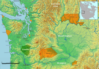
The term Cowlitz people covers two culturally and linguistically distinct indigenous peoples of the Pacific Northwest; the Lower Cowlitz or Cowlitz proper, and the Upper Cowlitz / Cowlitz Klickitat or Taitnapam. Lower Cowlitz refers to a southwestern Coast Salish people, which today are enrolled in the federally recognized tribes: Cowlitz Indian Tribe, Quinault Indian Nation, and Confederated Tribes of the Chehalis Reservation. The Upper Cowlitz or Taitnapam, is a Northwest Sahaptin speaking people, part of the Confederated Tribes and Bands of the Yakama Nation.

<span class="mw-page-title-main">Chinookan peoples</span> Group of Indigenous people in the Pacific Northwest

Chinookan peoples include several groups of Indigenous people of the Pacific Northwest in the United States who speak the Chinookan languages. Since at least 4000 BCE Chinookan peoples have resided along the upper and Middle Columbia River (Wimahl) from the river's gorge downstream (west) to the river's mouth, and along adjacent portions of the coasts, from Tillamook Head of present-day Oregon in the south, north to Willapa Bay in southwest Washington. In 1805 the Lewis and Clark Expedition encountered the Chinook Tribe on the lower Columbia.

<span class="mw-page-title-main">Quinault people</span> Native American peoples

The Quinault are a group of Native American peoples from western Washington in the United States. They are a Southwestern Coast Salish people and are enrolled in the federally recognized Quinault Tribe of the Quinault Reservation.

<span class="mw-page-title-main">Confederated Tribes of the Chehalis Reservation</span> Indian reservation in Washington, United States

The Confederated Tribes of the Chehalis Reservation is a federally recognized tribe located in Southwest Washington. The Confederation consists of the Upper and Lower Chehalis, Klallam, Muckleshoot, Nisqually, and Quinault peoples. They are a part of the Northern Straits branch Central Coast Salish peoples of indigenous peoples of the Northwest Coast.

<span class="mw-page-title-main">Humptulips River</span> River in Washington, United States

The Humptulips River is a river in Grays Harbor County, Washington, in the United States. Its main tributaries are the East Fork Humptulips River, about 20 miles (32 km) long (32 km), and West Fork Humptulips River, about 30 miles (48 km) long (48 km). After the forks join, the main river is approximately 20 miles (32 km) long.

<span class="mw-page-title-main">Washington State Route 109</span> State highway in Washington, United States

State Route 109 (SR 109) is a Washington state highway in Grays Harbor County. Beginning at its terminus at U.S. Route 101 (US 101) in Hoquiam, the highway travels west to intersect SR 115 near Ocean Shores and then turns north to continue along the Pacific coastline, terminating at the Quinault River Bridge in Taholah, located in the Quinault Indian Reservation. The Washington State Legislature extended the roadway north to end at US 101 south of Queets through tribal lands, although this segment has yet to be built. SR 109 was first established as Secondary State Highway 9C (SSH 9C) in 1937, which was on a more northern alignment until 1947, when it was switched to a Hoquiam to Quinault Indian Reservation route. In 1964, SSH 9C was renumbered to SR 109 and in 1983, a spur route of SR 109 that bypasses Hoquiam was added. SR 109 itself was extended by the legislature to US 101 near Queets in 1985, but the road has not been built.

<span class="mw-page-title-main">U.S. Route 101 in Washington</span> Section of U.S. Highway 101 in Washington (state), United States

U.S. Route 101 (US 101) is a United States Numbered Highway that runs along the West Coast from Los Angeles, California to Tumwater, Washington. Within the state of Washington, US 101 connects cities on the coast of the Pacific Ocean and encircles the Olympic Peninsula around the Olympic Mountains. It also serves as the main access for Olympic National Park, several state parks, and other scenic and recreational areas.

<span class="mw-page-title-main">Steamboats of Grays Harbor and Chehalis and Hoquiam Rivers</span>

Steamboats operated on Grays Harbor, a large coastal bay in the State of Washington, and on the Chehalis and Hoquiam rivers which flow into Grays Harbor near Aberdeen, a town on the eastern shore of the bay.

<span class="mw-page-title-main">Satsop River</span> River in Washington, United States

The Satsop River is a stream in the U.S. state of Washington. It has three main tributary forks, the East Fork, West Fork, and Middle Fork Satsop Rivers. The main stem Satsop River is formed by the confluence of the West and East Forks. The Middle Fork is a tributary of the East Fork. The three forks are much longer than the main stem Satsop itself, which flows south from the confluence only a few miles to join the Chehalis River near Satsop, Washington. Other significant tributaries include the Canyon River and Little River, both tributaries of the West Fork Satsop, and Decker Creek, a tributary of the East Fork Satsop River. The Satsop River's major tributaries originate in the Olympic Mountains and its southern foothills, the Satsop Hills, within Grays Harbor and Mason counties. Most of the Satsop River's watershed consists of heavily wooded hill lands. The upper tributaries extend into Olympic National Forest, approaching but not quite reaching Olympic National Park.

The Willapa or Willoopah, also known as Kwalhioqua / Kwalhiokwa, were a Northern Athapaskan-speaking people in southwestern Washington, United States. Their territory was the valley of the Willapa River and the prairie between the headwaters of the Chehalis and Cowlitz Rivers.

<span class="mw-page-title-main">Quinault Indian Nation</span> Ethnic group

The Quinault Indian Nation, formerly known as the Quinault Tribe of the Quinault Reservation, is a federally recognized tribe of Quinault, Queets, Quileute, Hoh, Chehalis, Chinook, and Cowlitz peoples. They are a Southwestern Coast Salish people of indigenous peoples of the Pacific Northwest Coast. Their tribe is located in Washington state on the Pacific coast of the Olympic Peninsula. These peoples are also represented in other tribes in Washington and Oregon.

<span class="mw-page-title-main">Cowlitz Indian Tribe</span> Indian tribe in Washington, United States

The Cowlitz Indian Tribe is a federally recognized tribe of Cowlitz people. They are a tribe of Southwestern Coast Salish and Sahaptan indigenous people of the Pacific Northwest located in Washington.

<span class="mw-page-title-main">Grays Harbor Transit</span>

The Grays Harbor Transportation Authority, doing business as Grays Harbor Transit, is a public transit agency serving Grays Harbor County in the U.S. state of Washington. It operates ten fixed bus routes traveling through the county's major cities and connecting to Olympia in Thurston County and Centralia in Lewis County, as well as paratransit service, dial-a-ride routes and a vanpool fleet. The agency, one of the first county transit authorities to be established in Washington state, began operations on June 16, 1975, and is one of few in the state that are not governed as a public transportation benefit area.

<span class="mw-page-title-main">Copalis River</span> River in Washington, United States

The Copalis River is a stream on the Olympic Peninsula in the U.S. state of Washington. It originates in the foothills on the southwest side of the Olympic Mountains and empties into the Pacific Ocean. The name "Copalis" comes from the Quinault language term /k'ʷpíls/. The Copalises are a Native American group. Both the Chehalis people and Quinault Indian Nation claim the Copalis are a subdivision of their tribe.

References

  1. "2010 Census CPH-T-6. American Indian and Alaska Native Tribes in the United States and Puerto Rico: 2010" (PDF). www.census.gov. Archived from the original (PDF) on December 9, 2014.