Chelia | |
|---|---|
Commune and town | |
 | |
 | |
| Country | |
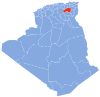
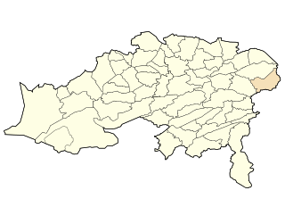
| Province | Batna Province |
| Population (1998) | |
• Total | 4,851 |
| Time zone | UTC+1 (CET) |
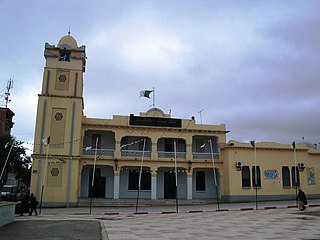
Chelia is a town and commune in Batna Province, Algeria. According to the 1998 census it had a population of 4,851. [1]
Chelia | |
|---|---|
Commune and town | |
| | |
| | |
| Country | |
| Province | Batna Province |
| Population (1998) | |
• Total | 4,851 |
| Time zone | UTC+1 (CET) |
Chelia is a town and commune in Batna Province, Algeria. According to the 1998 census it had a population of 4,851. [1]

The Barbary lion was present in the cedar forests and mountains near Chelia until about 1884. [2]

The Atlas Mountains are a mountain range in the Maghreb in North Africa. It separates the Sahara Desert from the Mediterranean Sea and the Atlantic Ocean; the name "Atlantic" is derived from the mountain range, which stretches around 2,500 km (1,600 mi) through Morocco, Algeria and Tunisia. The range's highest peak is Toubkal, which is in central Morocco, with an elevation of 4,167 metres (13,671 ft). The Atlas Mountains are primarily inhabited by Berber populations.
Locustdale is a census-designated place (CDP) that is located on the border of Columbia and Schuylkill counties, Pennsylvania, United States. It is part of Northeastern Pennsylvania.

Milledgeville is a town in Chester, Hardin, and McNairy counties, Tennessee, United States. The population was 265 at the 2010 census.

The Barbary lion was a population of the lion subspecies Panthera leo leo. It was also called North African lion, Atlas lion and Egyptian lion. It lived in the mountains and deserts of the Maghreb of North Africa from Morocco to Egypt. It was eradicated following the spread of firearms and bounties for shooting lions. A comprehensive review of hunting and sighting records revealed that small groups of lions may have survived in Algeria until the early 1960s, and in Morocco until the mid-1960s. Today, it is locally extinct in this region. Fossils of the Barbary lion dating to between 100,000 and 110,000 years were found in the cave of Bizmoune near Essaouira.

The Aures Mountains are a subrange of the Saharan Atlas in northeastern Algeria. The mountain range gives its name to the mountainous natural and historical region of the Aures.

Djebel Chélia is a mountain in Algeria. It is the highest point in the Aurès Mountains and the second highest peak in Algeria after Mount Tahat. Djebel Chélia is situated in the west of Khenchela, in Bouhmama county. Abiod Valley begins at the foot of Djebel Chélia.

MSV-Arena, currently known for sponsorship purposes as the Schauinsland-Reisen-Arena, is a football stadium in Duisburg, North Rhine-Westphalia, Germany, built in 2004. The stadium is the home of football club MSV Duisburg and American football club Rhein Fire. It has a capacity of 31,500. The stadium was built on the site of the old Wedaustadion. It was the venue of the 2005 World Games.

Cölbe is a municipality in Marburg-Biedenkopf district in Hesse, Germany.
Khenchela Province is a province (wilaya) in the Aures region in Algeria.

El Maharra is a municipality in El Bayadh Province, Algeria. It is part of Chellala District and has a population of 2.138, which gives it 7 seats in the PMA. Its postal code is 32360 and its municipal code is 3219.

Oulad Rechache is a district in eastern Khenchela, Algeria. It is one of the oldest areas in this state in the Middle Algeria that emerged as a district in 1990. It is adjacent to the state capital, and includes two municipalities. This district is located in a border area between Khanshalah and Tebessa and was important in fight against France during the Algerian Revolution. It is one of the most important areas to maintain the Tamazight language comparing to the state capital, where use of Chaouïa is widely relevant in all aspects of daily life. [[

The Edough Massif, Edough Mountains or Djebel Edough is a mountain range of the Maghreb area in Northern Africa.

Oued El Ma is a small town in the Aures region, and administratively is a municipality in the province of Batna. The name Oud El Ma is derived from the Berber name ″Ighzer n'Alma″, with 'Oud' means river that come from the mountains and 'Alma' means the mount of Telmet mountain.
Location
Ələsgər is a village in the Zaqatala Rayon of Azerbaijan. The village forms part of the municipality of Mamrux.

Tazoult District is a district of Batna Province, Algeria. The capital is Tazoult, a small city of 5,000 inhabitants.
El Khroub is a town and commune in Constantine Province, Algeria. According to the 2008 census it has a population of 179,033. it is a city in eastern Algeria, located a few kilometers from the city of Constantine. El Khroub is known for its archaeological site housing the tomb of Massinissa, around which a new city of the same name (Massinissa) was built.

Tegelberg is a mountain of Bavaria, Germany.
Prinčići is a village in the municipality of Sokolac, Bosnia and Herzegovina.
35°21′52″N6°46′43″E / 35.36444°N 6.77861°E
| | This article about a location in Batna Province is a stub. You can help Wikipedia by expanding it. |