Chelva

Last updated

Chelva
Escut de Xelva.svg
Spain location map with provinces.svg
Red pog.svg
Chelva
Location in Spain
Coordinates: 39°44′49″N0°59′51″W / 39.74694°N 0.99750°W / 39.74694; -0.99750
CountryFlag of Spain.svg  Spain
Autonomous community Flag of the Valencian Community (2x3).svg  Valencian Community
Province Valencia
Comarca Los Serranos
Judicial district Llíria
Government
   Alcalde David Cañigueral Belmonte
Area
  Total190.6 km2 (73.6 sq mi)
Elevation
800 m (2,600 ft)
Population
 (2018) [1]
  Total1,498
  Density7.9/km2 (20/sq mi)
Demonym(s) Chelvano, chelvana
Time zone UTC+1 (CET)
  Summer (DST) UTC+2 (CEST)
Postal code
46176
Official language(s) Spanish
Website Official website

Chelva is a municipality in the comarca of Los Serranos in the Valencian Community, Spain. Its name in Valencian is Xelva, but the local language is Spanish and not Valencian.

Contents

Geography

Chelva has an area of about 192 km2. The town is located in the middle of the mountains, and about 52% of its area is covered by typical Mediterranean woodlands. Two rivers flow through the municipality: one with the same name of the village (Chelva), and the other the Turia River, which flows to the Mediterranean via Valencia. The rivers do not meet in Chelva, but rather in adjacent Domeño.

The municipality is also home to several notable summits: the Cerro de la Nevera (1,259 metres or 4,131 feet), La Atalaya (1,157 metres or 3,796 feet), and the Pico del Remedio (1,054 metres or 3,458 feet). There are also several natural springs; the most well known are: Berra, Gitana, Gorgol, Sabina, and Cortina.

Chelva has a semiarid Mediterranean climate, with some rain in autumn and spring. In winter, it is cold, and in parts of the mountains snow is common.

Panoramica de Chelva.jpg
Panorama of Chelva

Demography

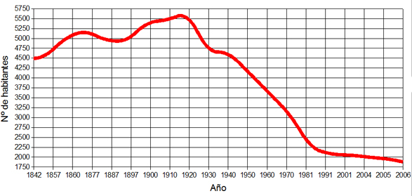
Since 1794—when its population was 7,200 inhabitants—the census has registered a gradual decline in population, to a total of fewer than 2000 inhabitants today. The population is distributed in the main city of Chelva as well as a few nearby villages: Villar de Tejas, Ahíllas, Alcotas, Mas de Caballero, Mas de Sancho, and El Cerrito.

Demographic evolution

18421857186018771887189719001910192019301940195019601970198119912001200420052006
44884499499952024947491154025457565246474652413036083078223420652046198619381877
DemografiaChelva.jpg

History

The Pena Cortada aqueduct Chelva Pena cortada.JPG
The Peña Cortada aqueduct
Municipal charter of Chelva (1369). Carta puebla de Chelva 1 - Archivo Reino de Valencia.JPG
Municipal charter of Chelva (1369).

The oldest archeological finds in Chelva are some paintings from the Neolithic era. From the Bronze Age we find a site in Nieva del Medio. Chelva was home to the ancient Iberians, evidenced by the remains of two villages in Torrecilla and Castillejo de Alcotas. Many examples of pottery, decorated with geometrical designs, have been found there, and some walls can still be seen.

The most important remains to be found in Chelva's limits are from the Roman epoch. From then we find the aqueduct called Peña Cortada, which stretches along Tuejar, Chelva, Calles, and Domeño, but with an unknown destination.

The origins of the present town can be found in the 11th century, when the ruling Moors established a fortress. The original city center was developed adjacent to the castle, and bore the name "Benacacira." It was enclosed by a wall with four gates (one is still visible, San Cristobal). Because of these fortifications, Chelva was a town of considerable importance during the Muslim rule.

Permanent Moorish control of the town ended in 1194, when the city was conquered by Peter II of Aragon. In 1214 the Muslims briefly retook Chelva, but by 1238 Christian troops took permanent control of the town.

The city was repopulated with Christians in 1390 and King John I bestowed upon Pedro Ladron de Vilanova the title of Viscount of Cheva. In later years, this title belonged to the Frigolas family, and finally, to Duke Villahermosa.

During the Revolt of the Brotherhoods in the 16th century, [2] the town was occupied by revolting agermanados troops.

In 1839 during the Carlist War, the city was fortified and converted in a hospital by General Cabrera.

Local festivals

San Antón: 17 January. On the closest weekend to this date people in Chelva make big fires to get the higher amount of "jewels" (live chickens). During this weekend the town also hosts an international oral storytelling festival: Cuentantón.

Holy Week . During the Holy week, apart from regular religious celebrations, Chelva celebrates a very special tradition: The first Sunday of Easter, after the procession of the Encuentro, thousands of "aleluyas" are thrown from the top of the church. These little pieces of paper are blessed and have religious inscriptions. People fight to get them because, according to tradition, they bring luck to those who manage to put them behind doors and windows forming a cross.

May fiesta: 30 April. Typical manifestation of traditional folklore. Accompanied by a group of musicians, people go around the city singing "Mayos". These are funny lines that, formerly, boys used to sing to girls in order to seduce them.

Youth week: July. During the week there are many activities, but the most important is the paella competition. On Friday night the townsfolk gather at the Plaza Mayor and compete to make the best paella. After the competition, a band stays in the square, performing the rest of the evening.

Our Lady of Remedio: August. A whole week full of activities, processions, and different bands playing every night. The festival also includes sports competitions like indoor football, marathon, chess, and fishing. There are also fireworks.

Related Research Articles

<span class="mw-page-title-main">Paella</span> Rice dish from the Valencian Community, Spain

Paella is a rice dish originally from the Valencian Community. Paella is regarded as one of the community's identifying symbols. It is one of the best-known dishes in Spanish cuisine.

<span class="mw-page-title-main">Alboraya</span> Municipality in Valencian Community, Spain

Alboraya or Alboraia is a town and municipality of the province of Valencia, Spain. It is situated very close to the city of Valencia.

<span class="mw-page-title-main">Altea</span> Municipality in Spain

Altea is a city and municipality located in the Valencian Community, Spain, on the section of Mediterranean coast called the Costa Blanca.

<span class="mw-page-title-main">Kingdom of Valencia</span> Monarchal state on the coast of the Iberian Peninsula (1238–1707)

The Kingdom of Valencia, located in the eastern shore of the Iberian Peninsula, was one of the component realms of the Crown of Aragon.

<span class="mw-page-title-main">Jérica</span> Town in Castellón, Spain

Jérica is a town in the Castellón province of Valencian Community, Spain. It is in the comarca (region) of Alto Palancia. Its population was 1,703 at the end of 2009.

<span class="mw-page-title-main">Sagunto</span> Municipality in Valencian Community, Spain

Sagunto is a municipality of Spain, located in the province of Valencia, Valencian Community. It belongs to the modern fertile comarca of Camp de Morvedre. It is located c. 30 km north of the city of Valencia, close to the Costa del Azahar on the Mediterranean Sea.

Chella is a municipality in the comarca of Canal de Navarrés in the Valencian Community, Spain.

<span class="mw-page-title-main">Paterna</span> Municipality in Valencian Community, Spain

Paterna is a city and a municipality in the province of Valencia in the Valencian Community, Spain. It is located northeast of the comarca of L'Horta de Valencia, 5 kilometres northwest of the inland suburbs of Valencia, and on the left bank of the river Turia. Its population in 2014 was 67,156 inhabitants, being the eleventh city by population in the Valencian Community.

<span class="mw-page-title-main">Picassent</span> Municipality in Valencian Community, Spain

Picassent is a municipality in the comarca of Horta Sud in the Valencian Community, Spain.

<span class="mw-page-title-main">Pinet, Valencia</span> Municipality in Valencian Community, Spain

Pinet is a municipality located in the north-east of the comarca of Vall d'Albaida in the south of the province of Valencia, Valencian Community, Spain, and some 82.6 km from the regional capital, Valencia.

<span class="mw-page-title-main">Simat de la Valldigna</span> Municipality in Valencian Community, Spain

Simat de la Valldigna is a municipality in the comarca of Safor in the Valencian Community, Spain. It is 50 km from Valencia, and 20 km from Cullera and Gandia. It is also near Xàtiva and Alzira.

<span class="mw-page-title-main">Sollana</span> Municipality in Valencian Community, Spain

Sollana is a municipality in the comarca of Ribera Baixa in the Valencian Community, Spain. The municipality includes a second village: El Romaní.

<span class="mw-page-title-main">Utiel</span> Municipality

Utiel is a municipality in the comarca of Plana de Utiel in the Valencian Community, Spain.

<span class="mw-page-title-main">La Yesa</span> Municipality and town in Valencian Community, Spain

La Yesa is a small town and municipality in the comarca of Los Serranos in the Valencian Community, Spain. The name in Valencian is La Iessa, but the local language is Spanish, not Valencian.

<span class="mw-page-title-main">Gines</span> Municipality in Andalusia Andalusia, Spain

Gines is a municipality in the south-west Spain, in the province of Seville, Andalusia. It is part of the metropolitan area of Seville. Gines has a population of 13,529 inhabitants as of 2021 and an area of 2.9 km2 (1.1 sq mi).

Relleu is a municipality in the comarca of Marina Baixa, Alicante, Valencia, Spain.

<span class="mw-page-title-main">La Vall d'Uixó</span> Place in Valencian Community, Spain

La Vall d'Uixó is a town situated in eastern Spain, in the Valencian province of Castelló. La Vall is located 25 km to the south of the province's capital Castelló, 45 km to the north of the community's capital Valencia and 8 km to the Mediterranean Sea, so it is at 118 m above sea level.

<span class="mw-page-title-main">Alcoy, Spain</span> Municipality in Valencian Community, Spain

Alcoy is an industrial and university city, region and municipality located in the Valencian Community, Spain. The Serpis river crosses the municipal boundary of Alcoy. The local authority reported a population of 61,135 residents in 2018.

Valencians are the native people of the Valencian Community, in eastern Spain. Legally, Valencians are the inhabitants of the community. Since 2006, the Valencian people are officially recognised in the Valencian Statute of Autonomy as a nationality "within the unity of the Spanish nation". The official languages of Valencia are Valencian and Spanish.

<span class="mw-page-title-main">Sagra, Alicante</span>

Sagra is a village in the province of Alicante and autonomous community of Valencia, Spain. The municipality covers an area of 5.6 square kilometres (2.2 sq mi) and as of 2011 had a population of 454 people.

References

  1. Municipal Register of Spain 2018. National Statistics Institute.
  2. "The Germanies War or the Revolt of the Brotherhood". Mallorca Days Out. Retrieved 10 July 2012.