
San Carlos Airport is two miles northeast of San Carlos, California, in San Mateo County, California.
Huron County Memorial Airport is a county-owned, public-use airport located one nautical mile (1.85 km) south of the central business district of Bad Axe, a city in Huron County, Michigan, United States. It is included in the Federal Aviation Administration (FAA) National Plan of Integrated Airport Systems for 2017–2021, in which it is categorized as a local general aviation facility.
Cherokee County Airport is a county-owned public use airport in Cherokee County, Texas, United States. It is located six nautical miles southeast of the central business district of Jacksonville, Texas.

Auburn University Regional Airport with the Robert G. Pitts Field is a public use airport located two nautical miles (4 km) east of the central business district of Auburn, a city in Lee County, Alabama, United States. The airport is owned by Auburn University and was formerly known as Auburn–Opelika Robert G. Pitts Airport. It is included in the National Plan of Integrated Airport Systems for 2011–2015, which categorized it as a general aviation facility.

John C. Tune Airport is a public airport located in the western portion of the city of Nashville in Davidson County, Tennessee, United States. It is owned by the Metropolitan Nashville Airport Authority, located approximately one mile off of Briley Parkway in the Cockrill Bend area. It is a Class D airport.
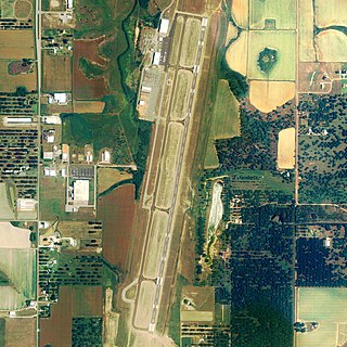
Iowa City Municipal Airport, is two miles southwest of downtown Iowa City, in Johnson County, Iowa. It is the oldest civil airport west of the Mississippi River still in its original location.
Cheboygan County Airport is a public use airport located two nautical miles (3.7 km) west of the central business district of Cheboygan, a city in Cheboygan County, Michigan, United States. It is owned by the Cheboygan Airport Authority. It is included in the Federal Aviation Administration (FAA) National Plan of Integrated Airport Systems for 2017–2021, in which it is categorized as a basic general aviation facility. The airport is accessible from Levering Road and is close to US Highway 23.
Burlington–Alamance Regional Airport is a public use airport in Alamance County, North Carolina, United States. It is located three nautical miles (6 km) southwest of the central business district of Burlington, North Carolina, and is owned by the Burlington–Alamance Airport Authority. This airport is included in the National Plan of Integrated Airport Systems for 2011–2015, which categorized it as a general aviation facility.

Western Carolina Regional Airport is a county-owned public-use airport located 2 miles (3.2 km) west of the central business district of Andrews, in Cherokee County, North Carolina, United States. It was formerly known as Andrews-Murphy Airport.

Nashua Airport at Boire Field is a public-use airport located three nautical miles (6 km) northwest of the central business district of Nashua, a city in Hillsborough County, New Hampshire, United States. Owned by the Nashua Airport Authority, It is included in the Federal Aviation Administration (FAA) National Plan of Integrated Airport Systems for 2017–2021, in which it is categorized as a national reliever airport facility.
Plant City Airport is a public-use airport located two nautical miles (4 km) southwest of the central business district of Plant City in Hillsborough County, Florida, United States. The airport is publicly owned by the Hillsborough County Aviation Authority, which also operates Tampa International Airport. It was formerly known as Plant City Municipal Airport. It supports a 400-acre (1.6 km2) industrial park located about one mile (1.6 km) east of the airport.
H. L. Sonny Callahan Airport is a public-use airport located three nautical miles southeast of the central business district of Fairhope, a city in Baldwin County, Alabama, United States. It is owned by the Fairhope Airport Authority.
Oswego County Airport is a county-owned, public-use airport three nautical miles (6 km) northeast of the central business district of Fulton, in Oswego County, New York, United States. The airport is located in Volney, New York. It has been designated by the Federal Aviation Administration as a general aviation reliever airport for Syracuse Hancock International Airport, located 25 miles (40 km) to the southeast.

Pennridge Airport is a public-use airport located one nautical mile north of the central business district of Perkasie in East Rockhill Township, Pennsylvania, United States. It is privately owned by Pennridge Development Ent., Inc.
Chester County G. O. Carlson Airport is a public airport two miles (3 km) west of Coatesville, in Valley Township, Chester County, Pennsylvania. It is owned by the Chester County Area Airport Authority.

Lee Gilmer Memorial Airport is a city-owned public-use airport located in Gainesville, a city in Hall County, Georgia, United States.

Indianapolis Executive Airport is a public airport at 11329 E. State Road 32, five miles north of Zionsville, in Boone County, Indiana, United States. The airport is owned by the Hamilton County Airport Authority. It is 14 miles (23 km) northwest of downtown Indianapolis and is a reliever airport for Indianapolis International Airport. In 2020, the airport was categorized as a "National" airport in the National Plan of Integrated Airport Systems.
Hannibal Regional Airport is a public use airport in Marion County, Missouri, United States. It is located four nautical miles (7 km) northwest of the central business district of Hannibal, Missouri, and is owned by the City of Hannibal. The airport is used for general aviation with no commercial airlines.
Northeast Ohio Regional Airport, owned and operated by the Ashtabula County Airport Authority, is a public-use airport in Ashtabula County, Ohio, United States, eight nautical miles (15 km) southeast of the central business district of the city of Ashtabula. Airport is located in Denmark Township near the Village of Jefferson, which is the County Seat of Ashtabula County. Located within minutes of Lake Erie and the intersection of major Interstates 90 (East/West) and 11 (North/South), the convenient location of the Northeast Ohio Regional Airport (HZY) makes it the perfect choice for both corporate and private travelers. The airport is located in the village of Jefferson, about 10 miles (16 km) south of Lake Erie. According to the FAA's National Plan of Integrated Airport Systems for 2009–2013, it is classified as a general aviation airport.
Carlisle Airport (Pennsylvania) (IATA: N94, ICAO: None, FAA LID: N94) is a publicly-owned, public use airport located one nautical miles (two mi, three km) southeast of the central business district of Carlisle, a city in Cumberland County, Pennsylvania, United States. This airport is owned and operated by South Middleton Township, Cumberland County, Pennsylvania.


