
Barlow is a city in Clackamas County, Oregon, United States. The population was 133 at the 2020 census. The mayor of Barlow is Michael Lundsten, as of the most recent election in 2018.

Oak Grove is an unincorporated community and census-designated place (CDP) in Clackamas County, Oregon, United States. The population was 17,290 as of the 2020 census.
Adrian is a city in Malheur County, Oregon, United States, near the confluence of the Snake River and the Owyhee River. The population was 177 at the 2010 census. It is part of the Ontario, OR–ID Micropolitan Statistical Area.
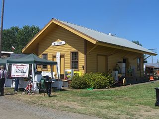
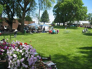
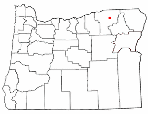
Brooks is an unincorporated community in Marion County, Oregon, United States. For statistical purposes, the United States Census Bureau has defined Brooks as a census-designated place (CDP). The census definition of the area may not precisely correspond to local understanding of the area with the same name. As of the 2020 census the population was 472. Brooks is part of the Salem Metropolitan Statistical Area.

Biggs Junction is an unincorporated community in Sherman County, Oregon, United States. For statistical purposes, the United States Census Bureau has defined Biggs Junction as a census-designated place (CDP). The census definition of the area may not precisely correspond to local understanding of the area with the same name.
Cayuse is a census-designated place (CDP) and unincorporated community in Umatilla County, Oregon, United States, located 11 miles (18 km) east of Pendleton on the Umatilla Indian Reservation. The population was 59 at the 2000 census. It is part of the Pendleton–Hermiston Micropolitan Statistical Area.

Carlton is a city in Yamhill County, Oregon, United States. The population was 2,135 as of the 2020 Census.

Mapleton is an unincorporated community and census-designated place (CDP) in Lane County, Oregon, United States. It is located on Oregon Route 126 and the Siuslaw River, 45 miles (72 km) west of Eugene and 15 miles (24 km) east of Florence. It is also the western terminus of Oregon Route 36. As of the 2000 census, Mapleton had a total population of 918.
Beatty is an unincorporated community and census-designated place (CDP) in Klamath County, Oregon, United States. Beatty is along Oregon Route 140 at the confluence of the Sycan and Sprague rivers and is 40 miles (64 km) by highway northeast of Klamath Falls.
Sprague River is an unincorporated community in Klamath County, Oregon, United States. It is about 45 miles (72 km) northeast of Klamath Falls near the Sprague River, northwest of Oregon Route 140.
Merlin is an unincorporated community and census-designated place (CDP) in Josephine County, Oregon, United States. As of the 2010 census it had a population of 1,615. The area is known for sport fishing and whitewater rafting on the Rogue River. Merlin's ZIP code is 97532.

Ruch is an unincorporated community and census-designated place (CDP) in Jackson County, Oregon, United States. It is located on Oregon Route 238, southeast of Grants Pass. As of the 2010 census, it had a population of 840.

Marcola is an unincorporated community and census-designated place (CDP) in Lane County, Oregon, United States, northeast of Springfield on the Mohawk River.

Crane is an unincorporated town and census designated place in Harney County, Oregon, United States, northeast of Malheur Lake on Oregon Route 78. Its population was 116 at the 2020 census.

Brogan is an unincorporated community and Census-designated place (CDP) in Malheur County, Oregon, United States, on U.S. Route 26. Brogan was founded by D. M. Brogan in 1909, and when a post office was established in the locality on April 23 that year, it was named for him. Brogan is located on the north end of the now-abandoned Union Pacific Railroad branch line from Vale.

Jasper is an unincorporated community and census-designated place (CDP) in Lane County, Oregon, United States. It is southeast of Springfield on Oregon Route 222, at the confluence of Hills Creek and the Middle Fork Willamette River.
Shedd is an unincorporated community and census-designated place (CDP) in Linn County, Oregon, United States, on Oregon Route 99E. As of the 2010 census it had a population of 204.

New Pine Creek is a census-designated place and unincorporated community in Lake County, Oregon, United States. As of the 2010 census, it had a population of 120. it has a post office with a ZIP code 97635. New Pine Creek lies on U.S. Route 395 at the Oregon–California border, just north of New Pine Creek, California, and east of Goose Lake.

Crabtree is an unincorporated community and census-designated place in Linn County, Oregon, United States. As of the 2010 census, it had a population of 391. It has a post office with a ZIP code of 97335. Crabtree lies off Oregon Route 226 about 10 miles (16 km) east of Albany.

Peoria is an unincorporated community and census-designated place (CDP) in Linn County, Oregon, United States. It is on the right bank of the Willamette River at river mile 141 between Eugene and Corvallis. Lacking stores and services, it is a cluster of houses plus a county park along Peoria Road, about 8 miles (13 km) south of Oregon Route 34 and 12 miles (19 km) north of Harrisburg. As of the 2010 census, the population was 94.


