North East Derbyshire is a local government district in Derbyshire, England. It borders the districts of Chesterfield, Bolsover, Amber Valley and Derbyshire Dales in Derbyshire, and Sheffield and Rotherham in South Yorkshire. The population of the district as taken at the 2011 Census was 99,023. The district council is a non-constituent partner member of the Sheffield City Region Combined Authority. The district is a non-constituent member of the Sheffield City Region and shares a membership along with neighbouring Derbyshire Dales, Borough of Chesterfield, Bolsover District and Bassetlaw District in Nottinghamshire. The district is also part of The Derby, Derbyshire, Nottingham and Nottinghamshire Local Enterprise Partnership.

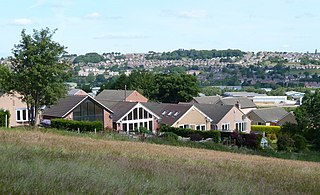
Clay Cross is a town and a civil parish in the North East Derbyshire district of Derbyshire, England. It is a former industrial and mining town, about 5 miles (8.0 km) south of Chesterfield. It is directly on the A61. Surrounding settlements include North Wingfield, Tupton, Pilsley and Ashover.

The Ashover Light Railway was a 1 ft 11+1⁄2 in narrow gauge railway in Derbyshire, England that connected Clay Cross and Ashover. It was built by the Clay Cross Company to transport minerals such as limestone, fluorite, barytes and gritstone to its works at Clay Cross and for transport around the country by the LMS.
The River Amber is a left bank tributary of the River Derwent in Derbyshire, England. It gives its name to the local government district and borough of Amber Valley.

Ogston Reservoir is a reservoir operated by Severn Trent Water in Derbyshire. It is near the villages of Brackenfield and Ashover and the town of Clay Cross.

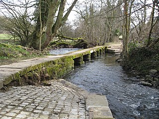
Ashover is a village and civil parish in the English county of Derbyshire. It is in the North East Derbyshire district of the county. The population of the civil parish taken at the 2011 Census was 1,905. It sits in a valley, not far from the town of Matlock and the Peak District national park.
Stretton railway station was a railway station at Stretton, Derbyshire, England built by the North Midland Railway.
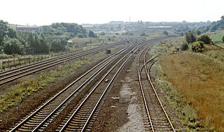
Clay Cross railway station was a railway station built by the North Midland Railway in 1840. It served the town of Clay Cross in Derbyshire, England.
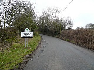
Alton is a very small village in Derbyshire, England. Alton is in the civil parish of Ashover, and is around 2 miles away from Clay Cross although it is not part of the town. The village does not have a church, a school or a public house; the nearest public house is in Ashover. Being a rural community, Alton is surrounded by several farms.
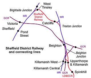
West Tinsley railway station is a former railway station in Sheffield, South Yorkshire, England.

The Devon and Somerset Railway (D&SR) was a cross-country line that connected Barnstaple in Devon, England, to the network of the Bristol and Exeter Railway (B&ER) near Taunton. It was opened in stages between 1871 and 1873 and closed in 1966. It served a mostly rural area although it carried some through services from east of Taunton to the seaside resort of Ilfracombe.

Holmgate is a hamlet and nearby housing estate between Clay Cross and Ashover, in the district of North East Derbyshire, England.
There are eight disused railway stations between Wadebridge and Bodmin North on the former Bodmin and Wadebridge Railway in Cornwall, in the United Kingdom, with ten other closed sidings on the branches to Ruthern Bridge and Wenfordbridge. The section from Boscarne Junction to Bodmin General is currently part of the Bodmin and Wenford Steam Railway; the line from Wadebridge to Wenfordbridge is now part of the Camel Trail, and the line to Ruthern Bridge can be followed for much of its length as it runs parallel to a public road.

Ashover Butts railway station was a railway station serving the village of Ashover in Derbyshire, England. It was the terminus of the 1 ft 11+1⁄2 in narrow gauge Ashover Light Railway.

The Clay Cross Company was founded as George Stephenson and Co. in 1837 by the railway pioneer, George Stephenson. The company established coal mines, ironworks, brickworks and pipe factories at Clay Cross near Chesterfield. The company was closed in 1998.

Clay Cross and Egstow railway station the terminus of the Ashover Light Railway and it served the Egstow area of Clay Cross, North East Derbyshire, England. The station had an unusually large nameboard which stood on the single low platform. There was a wooden station building consisting of an open-fronted wooden shelter, which had the manager's office on one side, and on the other what was intended as a parcels office, but was actually used as a general storeroom. The station was the only one on the line to enjoy electric lighting. After closure in 1950. The site was demolished and is now occupied by a road called Bridge Street.
Holmgate railway station was a small station on the Ashover Light Railway and it served the Holmgate area of Clay Cross, North East Derbyshire, England. The station had a siding capable of holding around six wagons. It was provided with a small wooden shelter and a telephone box. After closure in 1950. The site was demolished and is grazed to the ground.
Springfield railway station was a small station on the Ashover Light Railway and it served the western area of Clay Cross in North East Derbyshire, England. The station consisted of nothing more than a nameboard at a point where the line was crossed by a footpath. After closure in 1950 the site was demolished and nothing remains of the station or trackbed.
Clay Lane railway station was a small station on the Ashover Light Railway and it served the western area of Clay Cross in North East Derbyshire, England. The station had a wooden shelter and a telephone box. It was located about a quarter of a mile from the main street in Clay Cross, near the Royal Oak public house. The points were laid for a siding, but this was never built, due to meagre goods traffic. Despite this, passenger traffic was initially good. After closure in 1950. The site was demolished and nothing remains of the station or trackbed.
Woolley railway station was a small station on the Ashover Light Railway and it served the small village of Woolley Moor in North East Derbyshire, England. The station had a wooden shelter and a telephone box. As well as a platelayers hut. It was located just north of Ogston Reservoir, passenger traffic was initially good. After closure in 1950, the site was demolished and nothing remains of the station but the trackbed is visible although the section to Stretton has been submerged.