
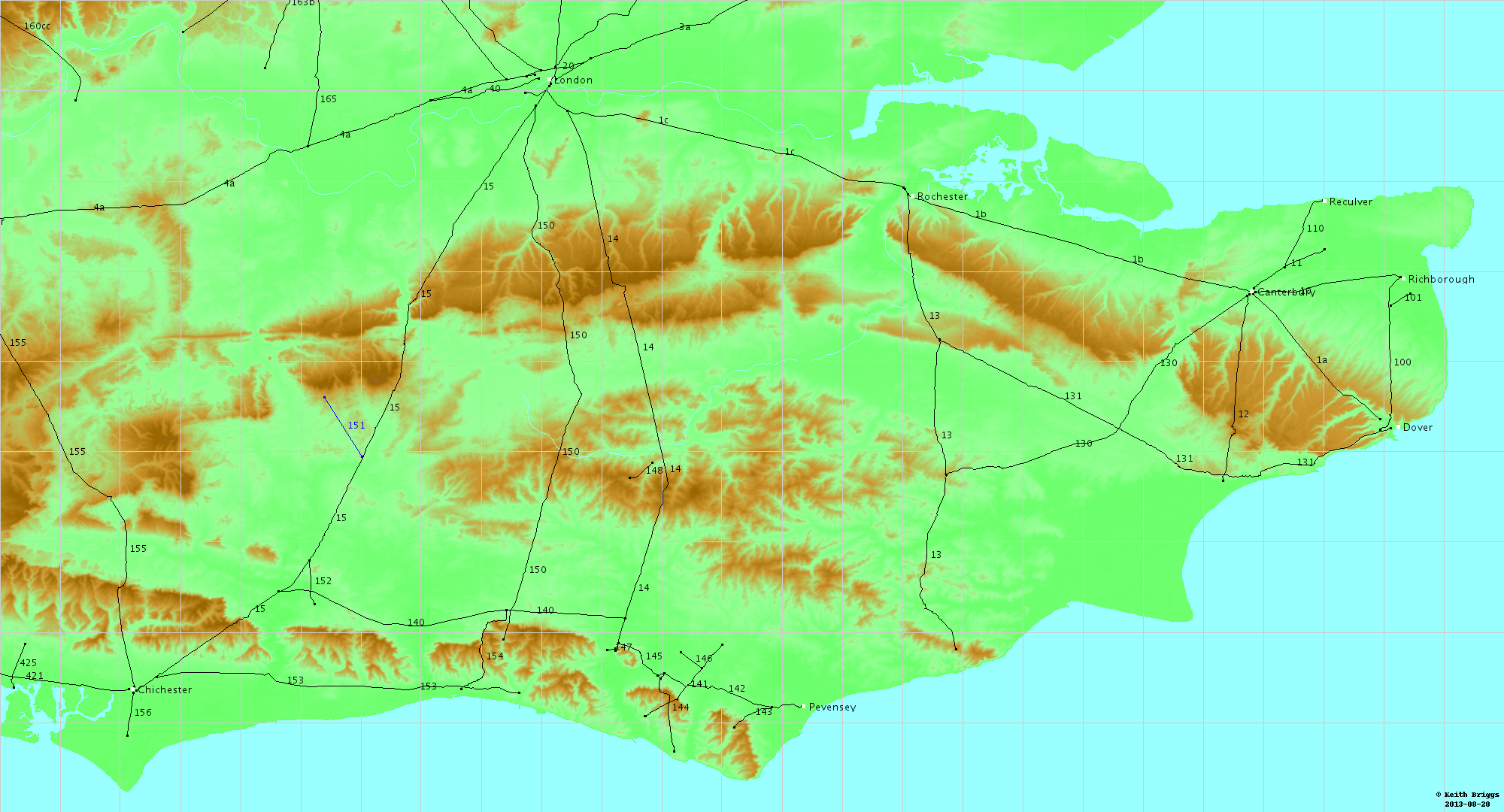
The Fosse Way was a Roman road built in Britain during the first and second centuries AD that linked Isca Dumnoniorum (Exeter) in the southwest and Lindum Colonia (Lincoln) to the northeast, via Lindinis (Ilchester), Aquae Sulis (Bath), Corinium (Cirencester), and Ratae Corieltauvorum (Leicester).
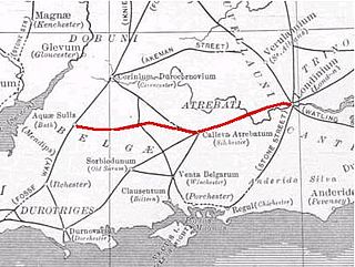
The Roman road from Silchester to Bath connected Calleva Atrebatum (Silchester) with Aquae Sulis (Bath) via Spinae (Speen), Cunetio and Verlucio. The road was a significant route for east–west travel and military logistics in south-east England during the 1st to 5th centuries.

The River Rother flows from Empshott in Hampshire, England, to Stopham in West Sussex, where it joins the River Arun. At 52 kilometres (32 mi) long, most of the river lies within West Sussex except for the first 10 kilometres (6.2 mi) which lie in Hampshire. The upper river, from its source to Midhurst, has been used to power watermills, with the earliest recorded use being in 1086, when the Domesday survey was conducted. Although none are still operational, many of the buildings which housed the mills still exist, and in some cases, still retain their milling machinery. This upper section is also noted for a number of early bridges, which have survived since their construction in the fifteenth, sixteenth and seventeenth centuries.

Roman roads in Britannia were initially designed for military use, created by the Roman Army during the nearly four centuries (AD 43–410) that Britannia was a province of the Roman Empire.

Foudry Brook is a small stream in southern England. It rises from a number of springs near the Hampshire village of Baughurst, and flows to the east and then the north, to join the River Kennet to the south of Reading. The upper section is called Silchester Brook, and beyond that, Bishop's Wood Stream. The underlying geology is chalk, covered by a layer of clay, and so it has the characteristics of a clay stream, experiencing rapid increases in level after heavy rain due to run-off from the surrounding land. It passes a number of listed buildings and scheduled monuments, including the site of the Roman town of Calleva Atrebatum or Silchester.
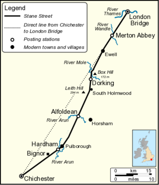
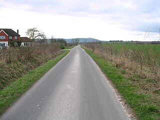
Stane Street is the modern name of the 91 km-long (57 mi) Roman road in southern England that linked Londinium (London) to Noviomagus Reginorum (Chichester). The exact date of construction is uncertain; however, on the basis of archaeological artefacts discovered along the route, it was in use by 70 AD and may have been built in the first decade of the Roman occupation of Britain.
An agger (Latin) is an ancient Roman linear mound or embankment. The word is sometimes applied to fortifications, such as the Agger Servianus, a part of the Servian Wall of Rome, which protected the city on its most vulnerable side, the Campus Esquilinus. It consisted of a double rampart bearing formidable fortifications. In modern usage however, particularly in British archaeology, it is most commonly used to describe the ridge or embankment on which Roman roads were built. The course of a Roman road can often be traced today by the distinctive line of the agger across the landscapeand even when destroyed by agriculture, the vestigial mound that can persist has allowed archaeologists in recent years to trace the course of many Roman roads using lidar.

In the Roman Empire, a mansio was an official stopping place on a Roman road, or via, maintained by the central government for the use of officials and those on official business whilst travelling.

Iping is a village and parish in the Chichester district of West Sussex, England. It lies within the civil parish of Stedham with Iping, just off the A272 road 2 miles (3.2 km) west of Midhurst. The village lies on the River Rother.

Milland is a village and civil parish in the Chichester district of West Sussex, England. It is situated north of the A272 road on the border with Hampshire.
Cunetio was a large walled town in a valley of the River Kennet in modern-day Wiltshire, England. The settlement was occupied from the 2nd century CE by Romano-British people until the post-Roman period, and was abandoned in the early 5th century. Its site is near the village of Mildenhall, about 1+1⁄2 miles (2.4 km) east of the market town of Marlborough.

Port Way is an ancient road in southern England, which ran from Calleva Atrebatum in a south-westerly direction to Sorbiodunum. Often associated with the Roman Empire, the road may have predated the Roman occupation of Britain.
The Sussex Greensand Way is a Roman road that runs east-west linking the London to Lewes Way at Barcombe Mills to Stane Street at Hardham. The road, which has almost entirely fallen out of use, follows the free draining ridge of greensand which lies north of the South Downs. It is a planned route rather than a Romanised Iron Age track, following a few straight alignments without any steep gradients, which linked various north-south roads and tracks. A number of important Roman villas and their farming estates were linked by the road. It is not known at what time during the Roman period the road was built.

The London to Lewes Way is a 71 kilometres (44 mi) long Roman road between Watling Street at Peckham and Lewes in Sussex. The road passes through Beckenham and West Wickham, then crosses the North Downs above Titsey, on the county boundary between Surrey and Kent, and is overlain by Edenbridge High Street. The road continues on this alignment onto the high ground of Ashdown Forest, where the more grassy vegetation on the silted up outer ditches contrasts very clearly with surrounding heather in aerial photographs, then descends through Piltdown to Lewes, linking with the Sussex Greensand Way at Barcombe Mills and with a network of roads at Lewes.

Ackling Dyke is a section of Roman road in England which runs for 22 miles (35 km) southwest from Old Sarum (Sorviodunum) to the hill fort at Badbury Rings (Vindocladia). Part of the road on Oakley Down has been scheduled as an ancient monument.

The London to Brighton Way, also called the London to Portslade Way, is a Roman road between Stane Street at Kennington Park and Brighton in Sussex. The road passes through Streatham and Croydon, then through the Caterham Valley gap in the North Downs. It passes through Godstone and Felbridge, then follows an almost straight line through Ardingly, Haywards Heath, Burgess Hill and Hassocks to the South Downs at Clayton. At Hassocks it crosses the Sussex Greensand Way at a large Roman cemetery. It climbs the South Downs escarpment, crossing the ridgeway and connecting with other local tracks. South of Pyecombe the route is uncertain, and may have continued to Brighton or to Portslade.
The New Lipchis Way is a 60.8 kilometres (37.8 mi) long distance footpath which runs from Liphook in Hampshire to West Wittering in West Sussex. Running north–south across the Western Weald and South Downs to the Sussex coastal plain and Chichester Harbour the path crosses several geological rock strata and their associated soils and habitats. Landmarks on the route include Cowdray ruins, Goodwood Racecourse, the Trundle, Chichester Cathedral and the city walls, and East Head at West Wittering.

West End Brook is a small stream in southern England. It rises near the Hampshire village of Tadley. Its name is probably related to the parish, and village, it passes through for some of its course: Mortimer West End.

The Street is the medieval name of the Roman road that ran across the high limestone plateau of central Derbyshire from the spa town of Buxton southeast towards modern Derby. The line of the road can be traced from surviving features, confirmed by archaeology, from Buxton as far as Longcliffe just north of Brassington. It is believed that from Brassington the road ran eastwards to Wirksworth and there joined another road which crossed the Derwent at Milford and ran on the east bank of the Derwent and can be traced to the northern suburbs of Derby to Little Chester, the site of the Roman settlement of Derventio. The 1723 map of Brassington Moor shows The Street road from Buxton through Pikehall up to the Upper Harborough Field Gate, leading onto Manystones Lane & Brassington Lane towards Wirksworth. In records from 1613 the road from Brassington to Wirksworth is called 'Highe Streete'.

The Devil's Highway was a Roman road in Britain connecting Londinium (London) to Calleva Atrebatum (Silchester) via Pontes (Staines). The road was the principal route to the west of Britain during the Roman period but whilst maintained for its easternmost section, was replaced by other routes after the demise of Roman Britain.


