
East Garden City was a census-designated place (CDP) in the northeast part of the Town of Hempstead, in the central part of Nassau County, New York, along the Hempstead/North Hempstead town line. The population was 6,208 at the 2010 census, when it was listed as a CDP. Since then, it is now included in the Uniondale CDP.

New City is a hamlet and census-designated place in the town of Clarkstown, Rockland County, New York, United States, part of the New York Metropolitan Area. An affluent suburb of New York City, the hamlet is located 18 miles (29 km) north of the city at its closest point, Riverdale, Bronx. Within Rockland County, New City is located north of Bardonia, northeast of Nanuet, east of New Square and New Hempstead, south of Garnerville and Haverstraw village, and west, straight across Lake DeForest, of Congers. New City's population was 33,559 at the 2010 census, making it the 14th most populous CDP/hamlet in the state of New York.

Nolita, sometimes written as NoLIta, and deriving from "North of Little Italy" is a neighborhood in the borough of Manhattan in New York City. Nolita is situated in Lower Manhattan, bounded on the north by Houston Street, on the east by the Bowery, on the south roughly by Broome Street, and on the west by Lafayette Street. It lies east of SoHo, south of NoHo, west of the Lower East Side, and north of Little Italy and Chinatown.

Gowanus is a neighborhood in the northwestern portion of the New York City borough of Brooklyn, within the area once known as South Brooklyn. The neighborhood is part of Brooklyn Community District 6. Gowanus is bounded by Wyckoff Street on the north, Fourth Avenue on the east, the Gowanus Expressway to the south, and Bond Street to the west.
Stanton Street is a west-to-east street in the New York City borough of Manhattan, in the neighborhood of the Lower East Side. The street begins at the Bowery in the west and runs east to a dead end past Pitt Street, adjacent to Hamilton Fish Park. A shorter section of Stanton Street also exists east of Columbia Street; it was isolated from the remainder of the street in 1959 with the construction of the Gompers Houses and the Masaryk Towers.

Rochdale Village is a housing cooperative and neighborhood in the southeastern corner of the New York City borough of Queens. Located in Community District 12, Rochdale Village is grouped as part of Greater Jamaica, corresponding to the former Town of Jamaica. It is adjacent to four other Queens neighborhoods: St. Albans to the east, South Jamaica to the west, Locust Manor to the north, and Springfield Gardens to the south across the Belt Parkway. Rochdale is about 2 miles (3.2
Manhattan Neighborhood Network (MNN) is an American non-profit organization that broadcasts programming on five public-access television cable TV stations in Manhattan, New York City. The country’s largest community media center, MNN operates two community media centers – in midtown Manhattan and East Harlem – and provides education, equipment, facilities, and programs to community producers and organizations who want to create programming to air on one of MNN's five channels. In 2016, MNN will post more than 5,000 enrollments in their media classes, making one of the largest media education institutions in New York City.

Stuyvesant Square is the name of both a park and its surrounding neighborhood in the New York City borough of Manhattan. The park is located between 15th Street, 17th Street, Rutherford Place, and Nathan D. Perlman Place. Second Avenue divides the park into two halves, east and west, and each half is surrounded by the original cast-iron fence.
Wingate is a neighborhood in the north central portion of the New York City borough of Brooklyn. The area is bordered by Prospect Lefferts Gardens to the west, Crown Heights to the north and east, and East Flatbush to the south. Wingate is bounded by Empire Boulevard to the north, Troy Avenue to the east, Winthrop Street to the south, and New York Avenue to the west. The area is part of Brooklyn Community District 9. It is sometimes considered part of Crown Heights, East Flatbush, and/or Prospect Lefferts Gardens.
Dos Blockos was a squat situated at 713 East 9th Street in Alphabet City, Manhattan, New York City. In active use as a squat from 1992 onwards, the six-story building housed up to 60 people at its peak, including Brad Will. The building funded repairs by being a set for movies including Trainspotting. The squatters were evicted in 1999 and the building was converted into a commercial apartment building.
Ledbetter/Eagle Ford is a neighborhood in West Dallas, Texas, United States.

The West Side Community Garden is a privately owned park in Manhattan, New York City, United States. It is located between West 89th Street and West 90th Street in the middle of the block between Amsterdam Avenue and Columbus Avenue.

The Church of St. Teresa is a Roman Catholic parish located at 16-18 Rutgers Street on the corner of Henry Street in the Lower East Side neighborhood of Manhattan, New York City. The parish is under the authority of the Archdiocese of New York. The church building was constructed in 1841-42 as the Rutgers Presbyterian Church erected in the Gothic Revival style on a plot of ground donated by Colonel Henry Rutgers, and it is said to have oldest public clock in New York City. The church was taken over by St. Teresa's Parish in 1863, only three years after it was founded.
Midtown South is a macro-neighborhood of the borough of Manhattan in New York City, generally characterized as constituting the southern portion of Midtown Manhattan. Midtown Manhattan hosts over 700,000 daily employees as a busy hub for workers, residents, and tourists. The Empire State Building, the Flatiron Building, Pennsylvania Station, Madison Square Garden, the Macy's Herald Square flagship store, Koreatown, and NYU Langone Medical Center are all arguably located in Midtown South.
Vleigh Playground is a 2.243-acre park in Kew Gardens Hills, Queens, New York City. It takes its name from Head of the Vleigh Road, a colonial period path that ran along the northern boundary of the playground site. This path is presently followed by Vleigh Place and 70th Road. This road connected the town of Flushing to Brooklyn during colonial times, allowing travelers to circumvent Flushing Meadows, then an impassible swamp.

Pier 42 is a pier in the Lower East Side of Manhattan, New York City. It was the last working cargo pier on the Manhattan shore of the East River, operating from 1963 to 1987. Since the early 2010s, plans have been underway to turn Pier 42 into a park.

Open Road Park is a small park in East Village, Manhattan, New York City, located east of First Avenue between 11th and 12th Streets. It is among the larger green spaces created in the East Village as a result of community organizing. The site of this park was taken over in 1993 by Open Road, a neighborhood nonprofit that developed the lot into a community garden and playground. Prior to its use as a park, the site was used for many purposes that reflect on the history of the surrounding neighborhood.
Estella Diggs Park is a 0.9-acre (0.36 ha) public park in the Morrisania neighborhood of the Bronx, New York City. It was built on one of many vacant lots in Morrisania that resulted after some of the neighborhood's buildings were abandoned and demolished in the 1960s. The New York City Parks Department acquired this property in 1978 and it was briefly used as a community garden but later again became vacant. At the time, community organizer Megan Charlop led a protest effort against the movie Fort Apache, The Bronx arguing that it negatively depicted the neighborhood. As a compromise, the producers issued a $15,000 check to the fledgling Rock Greening Association, a community land trust Charlop had helped establish to acquire the empty lot where filming took place. The lot was then given to the city. In 1990, additional lots were acquired by Parks and the site was named Rocks and Roots Park.
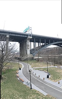
Bridge Park is a park in the Bronx, New York, created as part of a larger vision of creating connected waterfront parks along both sides of the Harlem River. The park's name references three large arch bridges linking Manhattan and the Bronx: Alexander Hamilton Bridge, Washington Bridge, and High Bridge.
Taqwa Community Farm is a half-acre park operated as a community garden in the Highbridge neighborhood of the Bronx, New York City.