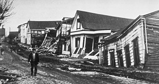
The 1960 Valdivia earthquake and tsunami or the Great Chilean earthquake on 22 May 1960 was the most powerful earthquake ever recorded. Various studies have placed it at 9.4–9.6 on the moment magnitude scale. It occurred in the afternoon, and lasted for approximately 10 minutes. The resulting tsunamis affected southern Chile, Hawaii, Japan, the Philippines, eastern New Zealand, southeast Australia, and the Aleutian Islands.

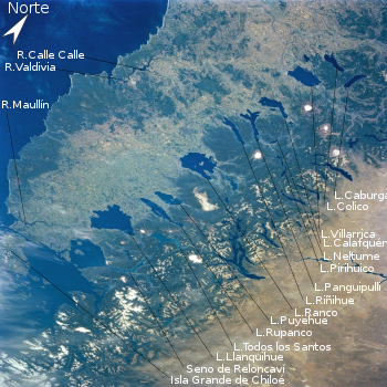
Los Lagos Region is one of Chile's 16 regions, which are first order administrative divisions, and comprises four provinces: Chiloé, Llanquihue, Osorno and Palena. The region contains the country's second largest island, Chiloé, and the second largest lake, Llanquihue. Its capital is Puerto Montt; other important cities include Osorno, Castro, Ancud, and Puerto Varas. The mainland portion of Los Lagos Region south of Reloncaví Sound is considered part of Patagonia.

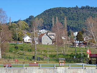
Frutillar is a city and commune located in southern Chile, Chilean Patagonia, in Llanquihue Province, within the Los Lagos Region, the lake district. The bay of Frutillar is placed on the banks of Lake Llanquihue, the largest lake entirely within Chile. Frutillar is known as the "City of Music", and since 2017 is part of the UNESCO Creative Cities Network (UCCN), becoming the first Chilean city to be nominated, as well as the southernmost Creative City of Music in the world.

Villarrica is one of Chile's most active volcanoes, rising above the lake and town of the same name, 750 km (470 mi) south of Santiago. It is also known as Rucapillán, a Mapuche word meaning "great spirit's house" or " the demon's house". It is the westernmost of three large stratovolcanoes that trend northwest to southeast obliquely perpendicular to the Andean chain along the Mocha-Villarrica Fault Zone, and along with Quetrupillán and the Chilean portion of Lanín, are protected within Villarrica National Park. Guided ascents are popular during summer months.

The Los Ríos Region is one of Chile's 16 regions, the country's first-order administrative divisions. Its capital is Valdivia. It began to operate as a region on October 2, 2007, having been created by subdividing the Los Lagos Region in southern Chile. It consists of two provinces: Valdivia and the newly created Ranco Province, which was formerly part of Valdivia Province.
Villarrica is a city and commune in southern Chile located on the western shore of Villarrica Lake in the Province of Cautín, Araucanía Region 746 km (464 mi) south of Santiago and close to the Villarrica Volcano ski center to the south east. Residents of Villarrica are known as Villarricences.

Osorno Province is one of the four provinces in the southern Chilean region of Los Lagos (X). The province has an area of 9,223.7 km2 (3,561 sq mi) and a population of 221,496 distributed across seven communes. The provincial capital is the city of Osorno.

Cautín Province is one of two provinces in the southern Chilean region of La Araucanía (IX), bounded on the north by Arauco and Malleco provinces, on the east by Argentina, on the south by Valdivia Province, and on the west by the Pacific Ocean. Its population at the 2012 census was of 692,582. The most important communes are Temuco, Villarrica, Padre Las Casas, and Nueva Imperial. Cattle, forestry, and agriculture make up most of Cautin's economy. Its climate is humid, rainy in winter, and generally warm in summer.

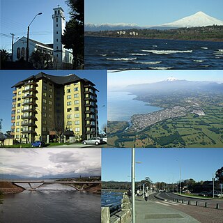
Valdivia is a city and commune in southern Chile, administered by the Municipality of Valdivia. The city is named after its founder, Pedro de Valdivia, and is located at the confluence of the Calle-Calle, Valdivia, and Cau-Cau Rivers, approximately 15 km (9 mi) east of the coastal towns of Corral and Niebla. Since October 2007, Valdivia has been the capital of Los Ríos Region and is also the capital of Valdivia Province. The national census of 2017 recorded the commune of Valdivia as having 166,080 inhabitants (Valdivianos), of whom 150,048 were living in the city. The main economic activities of Valdivia include tourism, wood pulp manufacturing, forestry, metallurgy, and beer production. The city is also the home of the Austral University of Chile, founded in 1954 and the Centro de Estudios Científicos.

Osorno is a city and commune in southern Chile and capital of Osorno Province in the Los Lagos Region. It had a population of 145,475, as of the 2002 census. It is located 945 kilometres (587 mi) south of the national capital of Santiago, 105 kilometres (65 mi) north of the regional capital of Puerto Montt and 260 kilometres (160 mi) west of the Argentine city of San Carlos de Bariloche, connected via International Route 215 through the Cardenal Antonio Samoré Pass. It is a gateway for land access to the far south regions of Aysén and Magallanes, which would otherwise be accessible only by sea or air from the rest of the country.

Puyehue National Park is located in the Andes mountain range, in Los Ríos and Los Lagos regions of Chile formerly referred to as the 10th region. The park boast 220,000 acres of natural thermal springs, volcanoes, and evergreen forests, after having been expanded in 1950 and 1981. The park is Chile's most visited national park with 400,000 people enjoying it each year. Puyehue National park forms part of the Reserve of Temperate Rainy Forest Biospheres of the Southern Andes. Chile Route 215 passes through the park, which connects with the Argentine Route 231 via Cardenal Antonio Samoré Pass.

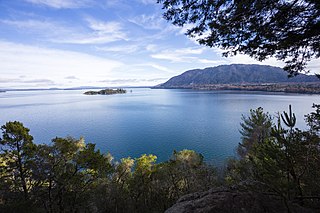
Puyehue Lake, is an Andean piedmont lake on the border of Los Lagos Region with Los Ríos Region of Chile.
Calafquén Lake is a lake of Chile, which straddles the border between the La Araucanía Region and Los Ríos Region. It is one of the Seven Lakes and forms part of the drainage basin of the Valdivia River.

Zona Sur is one of the five natural regions on which CORFO divided continental Chile in 1950. Its northern border is formed by the Bío-Bío River, which separates it from the Central Chile Zone. The Southern Zone borders the Pacific Ocean to the west, and to the east lies the Andean mountains and Argentina. Its southern border is the Chacao Channel, which forms the boundary with the Austral Zone. While the Chiloé Archipelago belongs geographically to the Austral Zone in terms of culture and history, it lies closer to the Southern Zone.

The Zona Austral is one of the five natural regions into which CORFO divided continental Chile in 1950 corresponding to the Chilean portion of Patagonia. It is surrounded by the Zona Sur and the Chacao Channel to the north, the Pacific Ocean and Drake's Passage to the south and west, and the Andean mountains and Argentina to the east. If excluding Chiloé Archipelago, Zona Austral covers all of Chilean Patagonia.
Lago Ranco is a town and commune in southern Chile administered by the Municipality of Lago Ranco. It is located in Ranco Province in Los Ríos Region. Lago Ranco takes its name from Ranco Lake, which it shares with the commune of Futrono.

Bueno River is a river in southern Chile. It originates in Ranco Lake and like most of Chile rivers it drains into the Pacific Ocean at the southern boundary of the Valdivian Coastal Reserve. Its lower flow forms the border between Osorno Province and Ranco Province. Traditionally it marks also the northern boundary of the indigenous Huilliche territory known as Futahuillimapu. The river passes through Río Bueno commune and city that takes name from the river.

Since the mid-1990s, tourism in Chile has become one of the main sources of income for the country, especially in its most extreme areas. In 2005, this sector grew by 13.6%, generating more than US$500 million, equivalent to 1.33% of the national GDP.
The following lists events that happened during 1960 in Chile.