Guerrero, officially the Free and Sovereign State of Guerrero, is one of the 32 states which comprise the 32 Federal Entities of Mexico. It is divided in 81 municipalities and its capital city is Chilpancingo and its largest city is Acapulco. It is located in Southwestern Mexico. It is bordered by the states of Michoacán to the north and west, the State of Mexico and Morelos to the north, Puebla to the northeast and Oaxaca to the east. In addition to the capital city, the state's largest cities include Acapulco, Petatlán, Ciudad Altamirano, Taxco, Iguala, Ixtapa, Zihuatanejo, and Santo Domingo. Today, it is home to a number of indigenous communities, including the Nahuas, Mixtecs, Tlapanecs, Amuzgos, and formerly Cuitlatecs. It is also home to communities of Afro-Mexicans in the Costa Chica region.

Chilpancingo de los Bravo is the capital and second-largest city of the state of Guerrero, Mexico. In 2010 it had a population of 187,251 people. The municipality has an area of 2,338.4 km2 (902.9 sq mi) in the south-central part of the state, situated in the Sierra Madre del Sur, on the bank of the Huacapa River. The city is on Mexican Federal Highway 95 which connects Acapulco to Mexico City. It is served by Chilpancingo National Airport, which is one of the five airports in the state.

Piedras Negras is a city and seat of the surrounding municipality of the same name in the Mexican state of Coahuila. It stands at the northeastern edge of Coahuila on the Mexico–United States border, across the Rio Grande from Eagle Pass in the U.S. state of Texas. In the 2015 census the city had a population of 163,595 inhabitants, while the metropolitan area had a population of 245,155 inhabitants. The Piedras Negras and the Eagle Pass areas are connected by the Eagle Pass–Piedras Negras International Bridge, Camino Real International Bridge, and the Union Pacific International Railroad Bridge.

Coatzacoalcos is a major port city in the southern part of the Mexican state of Veracruz, mostly on the western side of the Coatzacoalcos River estuary, on the Bay of Campeche, on the southern Gulf of Mexico coast. The city serves as the municipal seat of the municipality of the same name. It is the state's third largest city, after Veracruz City and Xalapa.

Guerrero is a state in Southwest Mexico that is divided into 81 municipalities. According to the 2015 Mexican Intercensal Survey, Aguascalientes is the 12th most populous state with 3,533,251 inhabitants and the 14th largest by land area spanning 63,803.42 square kilometres (24,634.64 sq mi).

Tixtla is a town and seat of the Tixtla de Guerrero Municipality in the Mexican state of Guerrero.
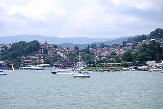
Valle de Bravo is a town and municipality located in State of Mexico, Mexico. It is located on the shore of Lake Avándaro, approximately 156 km southwest of Mexico City and west of Toluca on highways 15, 134 or 1. It takes about two hours to drive from Mexico City to Valle de Bravo, making it a popular weekend getaway for the capital's affluent upper class.

Metro Chilpancingo is an underground metro station along Line 9 of the Mexico City Metro. It is located in the Cuauhtémoc borough of Mexico City. It is very close to Metrobús station of the same name. In 2019, the station had an average ridership of 49,122 passengers per day, making it the busiest station in Line 9 and the 17th busiest station in the network.
Santo Tomás de los Plátanos also known as Nuevo Santo Tomás de los Plátanos is a town and governmental seat of the municipality of Santo Tomás, located in the center-west of Mexico State, in Mexico. It is approximately 185 km from Mexico City, and 107 km from Toluca.
Chichihualco is a city in the south of Mexico. It forms the administrative centre of the municipality of Leonardo Bravo, found in the centre of Guerrero state about 21 kilometres northwest of the state capital, Chilpancingo.
Federal Highway 95 connects Mexico City to Acapulco, Guerrero. The Autopista del Sol is a tolled alternative, which bypasses several towns of the state of Guerrero, including the city Iguala, and thus reduces from 8 hours to almost 3.5 hours the time required to get to Acapulco from Mexico city.

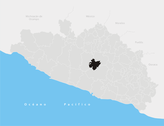
Coyuca de Catalán is one of the 81 municipalities of Guerrero, in south-western Mexico. The municipal seat lies at Coyuca de Catalán. The municipality covers an area of 921.9 km².
Leonardo Bravo is one of the 81 municipalities of Guerrero, in south-western Mexico. The municipal seat lies at Chichihualco. The municipality covers an area of 852 km².
General Heliodoro Castillo is one of the 81 municipalities of Guerrero, in south-western Mexico, located 34 kilometres from Chilpancingo. The municipal seat lies at Tlacotepec. This town is named after a prominent general. The municipality covers an area of 1,613.8 km².
Petatlán Municipality is one of the 81 municipalities of Guerrero, in south-western Mexico. The municipal seat lies at Petatlán. The municipality covers an area of 2,071.7 km².

Coyuca de Catalán is a city and seat of the municipality of Coyuca de Catalán, in the state of Guerrero, south-western Mexico.

Apaxco is a municipality located in the Zumpango Region in Mexico. The municipal territory is located at a southern pass leading out of the Mezquital Valley about 288 km (179 mi) northeast of the state capital of Toluca. The name Apaxco comes from Nahuatl.

Mario Moreno Arcos is a Mexican politician from the Institutional Revolutionary Party. From 2009 to 2012 he served as Deputy of the LXI Legislature of the Mexican Congress representing Guerrero.
Same-sex marriage is not legal in the Mexican state of Guerrero. After the Supreme Court of Justice of the Nation's ruling, in which it ruled same-sex marriage bans unconstitutional, went into effect on 22 June, officials in Guerrero began announcing plans for a collective group wedding. Governor Rogelio Ortega Martínez submitted a same-sex marriage bill to Congress on 7 July 2015 and instructed civil agencies to approve same-sex marriage licenses. Legislators lamented they would have preferred to have the bill passed before marriages took place, but given the time line presented, it was unlikely. On 10 July 2015, twenty same-sex couples were married by the Governor in Acapulco.

Antonia Nava de Catalán was a heroine of the Mexican War of Independence. She accompanied her husband, a volunteer who rose to the rank of colonel, throughout the war. Three of her sons were killed in the struggle. She is remembered for her willingness to sacrifice her family and herself to achieve independence from Spain, and came to be known as "La Generala". She fought alongside Jose Maria Moreles until her death.