The name Chimborazo comes from a volcano in Ecuador. It is believed that the Richmond hill was dubbed Chimborazo around 1802, the year of Alexander von Humboldt’s unsuccessful attempt to scale the mountain in Ecuador.[4] Chimborazo Hill was one of Richmond's "seven hills"[5] and thought to have been so named by a local world-traveler because of its topographical likeness to the Ecuadorian volcano.[6] A brewery had dug cellars in the Richmond hill to store beer. At the top of the cellars was a hole that acted as a chimney. A Richmond newspaper reported that any fire in the cellar would cause "billows of smoke [to come] through making the hill look like a miniature Vesuvius."[7]
Shortly after being suggested as the location for the state Capitol building in 1780,[8] the hill (while unclear as to whether it was yet named Chimborazo) was the assemblage place for a "couple of hundred raw, poorly equipped militia, who were hurriedly corralled and drawn up" to protect Richmond when Benedict Arnold and British troops converged on the city in January, 1781. "When the militia saw what was coming, they decided to a man, to live to fight another day, and skedaddled".[9]
Toward the end of the 18th century and beginning of the 19th century, Chimborazo Heights was said to have been a "favorite dueling ground" and "several lives were thus sacrificed there."[10] Before the war, it was "a common, chiefly occupied by grazing cows and ball-playing, kite-flying boys, and not unfrequently the scene of hard-fought rock-battles between the "Hill boys" and the "Butchertown cats."[11]
Prior to its use as a hospital during the Civil War, the hill had been used to organize the troops coming into Richmond.[12] When the war started, several large regiments camped on and around Chimborazo Hill and built extensive wooden barracks for shelter. As these soldiers went off to the front lines, they left behind as many as 100 nearly-new wooden buildings which were commandeered by Samuel P. Moore, the Surgeon General of the Confederate States of America for the establishment of a hospital.[13] At the time the hospital was established, aside from the barracks constructed by the soldiers, only two buildings were located on the hill: a large house owned by Richard Laughton and a small office building.[14]
On maps pre-dating the Civil War, "Chimborazo Hill" is shown located in Henrico County just to the east of the city line.[15] That portion of Henrico County containing Chimborazo Hill was annexed by Richmond in 1867.[16]
On the south side of the park, overlooking the James River, is a stone commemorating the hospital; it was placed by the Confederate Memorial Literary Society in 1934. The stone is appropriately sited, overlooking the Confederate Navy Yard on the James River and riverside Rocketts Landing.[18]
A bronze plaque on the stone reads as follows:
On this hill stood Chimborazo Hospital 1862-1865
Established by Surgeon General S.P. Moore, C.S.A. Directed by Dr. James B. McCaw.
At that time, it was the largest military hospital in the world. It consisted of 150 buildings and 100 tents and cared for 76,000 patients with a mortality of less than 10 per cent.
This tablet is placed by the Confederate Memorial Literary Society 1934
Freedmen's Community (1865-1866)
After the end of the Civil War, what was once the largest Confederate hospital in the country became the site of a refuge camp for former slaves, managed by the Freedmen's Bureau. Many of the buildings were used briefly as a day school while other buildings were torn down and the wood used for construction or firewood. The community, however, did not last long as the refuge camp was closed soon after it opened. In March, 1866, the Freedmen's Bureau ordered all able-bodied men to vacate their lodgings in the park by April 1.[19] Over time, the City of Richmond purchased the land piece by piece, in many cases using public condemnation, slowly removing the freedmen's community from Chimborazo Hill. The city council auctioned off the last remaining wooden houses in 1880, removing all traces of the previous community to make way for Chimborazo Park. The last of the structures disappeared around 1900.[20][21]
Formation of Chimborazo Park
On October 26, 1874, Richmond's Board of Alderman took up a resolution to purchase 35 acres on Richmond's Chimborazo Hill at a cost of $35,000. A report prepared by the Committee on Public Grounds and Buildings noted the importance of public parks:
The opening and improvement of small squares in different parts of the city is not a mere question of ornament and improvement to taxable property, beautifying the city at the same time of increasing its taxable wealth, but is a question of great public benefit – a real health measure, conferring a blessing on the humblest and poorest citizens, while it adds largely to the material prosperity of our whole people. With a densely crowded population, these open spaces will in time prove to be of inestimable value to the city.
A public park is simply an expanded idea of our small squares – "sanitarians" as they are sometimes called. It is the cherished work of every city with any claim to progress and comfort, and is as much the index of material prosperity as it is of the cultivated taste and refinement of an enlightened people.
The report urges an immediate step to secure grounds for a park as an economical measure and investment by the city, as the extensions of our water-works are threatened to be hemmed in with factories and sewers if the city does not secure the ground along our river front with a reasonable distance of the works. The extension of these works must require additional ground, and in providing for a park we can accomplish the two ideas together. This combination of water-works and park grounds is the example of all large cities, and in carrying this out we shall be simply repeating what others have done, with the benefit of all their experiences.
The Committee recommended the issuance of bonds for the purchase of the land and that annual funds be set aside for its upkeep. The resolution was adopted by the Board of Alderman on November 10, 1874.[22]
One of the earliest descriptions of the park was made in The Daily Dispatch, a local Richmond newspaper, covering the maiden round-trip voyage of the steamer The City of Richmond between Richmond and Norfolk on August 27, 1880. The ongoing construction of the park was referenced as “changing it from an eyesore to a thing of beauty – to be a joy forever, in particular for those who approach Richmond by water. From its prominence – towering high above all other hills – it deserves to be handsomely improved. First appearances are everything with the traveler. If he is disgusted with a city upon entering it, afterwards it is difficult to make him see any good in it.” The newspaper proclaimed that once the plans for Chimborazo Park, as well as Libby Hill Park, “are carried out in full, Richmond will present to the stranger who enters her gates by James River a face of unusual charms.”[23]
Postcard of Chimborazo Park from the early 20th Century. The card text reads: Chimborazo Park, the joy and pride of the eastern portion of the city, situated on a bluff many feet above James River, from which a beautiful view of the surrounding country may be obtained.
While referred to before its establishment as a park as "naturally picturesque, though at present very unattractive",[24] local newspapers would soon describe the beauty and serenity of the new park. In 1886, it was described as "once occupied by a crowd which made night hideous, is now as lovely a spot as can be found."[25] In later years, it was described as "a park equal in beauty of elevation and perspective to any certainly in this part of the country" (1887),[26] a "place of popular resort" (1897)[27] and "a beautiful and elevated plateau, having a magnificent view of the river for twelve or fourteen miles" (1900).[28] Referring to its height, it was once called "the frowning Gibralter of the range".[29]
During its early phases of development, the neighborhood around Chimborazo Park was advertised as a Suburban Resort, a green landscape offering residents open spaces in which to enjoy fresh air, exercise, participate in various social activities, and admire majestic views of the James River. To draw residents to the park, the city extended a streetcar line to Chimborazo Park in the late 19th century. City officials believed the park would reduce social unrest, increase the physical and mental health of its citizens, provide appropriate spaces for recreation, and provide green buffers between industrialized regions and residential districts.[30]
Over the years, several monuments have been placed in the park to memorialize the city's past. Because of its "conspicuous height" and "commanding position", the park was even suggested as the appropriate location for monuments to Jefferson Davis[31] and Robert E. Lee.[32] as well as a monument to the women of the Confederacy.[33] It was also once suggested as the site for a city trotting park.[34]
Early on, the park was called "progressive" as it was one of the first parks in the city to prohibit walking on the grass, the first to open a municipal playground in the city and the first to screen free movies for the public.[35]
Periodically, calls for changing the name of the park would be made. In 1909, Preston Cocke, a well-known Richmond lawyer, proposed the park be renamed "Maury Park" in honor of Matthew Fontaine Maury, the "Pathfinder of the Seas".[36] In 1910, claiming that "there is no fitness in the name [Chimborazo] applied to anything in Richmond", a call was made to rename the park "Bloody Run Park" in honor of the Battle of Bloody Run which took place nearby in 1656.[37]
Today, the park sits on 27.9 acres owned by the City of Richmond and 5.6 acres owned by the federal government.[38]
The Chimborazo Medical Museum is located in the northwest corner of Chimborazo Park (at the corner of East Broad and North 32nd Streets). The museum focuses on the Confederate medical story and contains exhibits on medical equipment and hospital life, including information on the men and women who staffed Chimborazo Hospital. The building is also the headquarters for the Richmond National Battlefield Park and Maggie L. Walker National Historic Site which are located elsewhere in the city.[42]
The building in which the museum is located was originally built as a weather station in 1909 after the federal government bought a 150 square foot plot of land from the city. The U.S. Weather Bureau maintained records of local conditions and tracked extreme weather events at the station from February, 1910 to June, 1953.[43][44] The highest temperature ever recorded at the station was 107 degrees on August 6, 1918.[45] In 1954, the federal government deeded the building to the City of Richmond.
Richmond explored numerous uses for the building, including a health clinic, a community center, and a shelter for troubled youth, plans which met resistance among neighborhood residents. In 1957, Richmond officials returned the building to the federal government for use as the headquarters for the Richmond National Battlefield Park, administered by the National Park Service.[46][47]
Powhatan Stone
Powhatan Stone
On the south side of the park, overlooking the James River, is a stone commemorating King Powhatan and his relationship with Captain John Smith and the English settlement in Jamestown known as the "Powhatan Stone". The stone was placed in the park in the 1950s by the Association for the Preservation of Virginia Antiquities.[48]
The Mayo family, descendants of the city's original surveyor, William Mayo, had lived for generations at a house on the hill east of Richmond they called "Powhatan’s Seat". The location was likely that of the local village of the Powhatan's own tribe. The family carefully preserved at their house a talisman in the form of a stone said to have formed part of Powhatan's house which was sited in the native village at the falls in Richmond. According to one source, the stone, covered with "Indian designs", also marked the grave of William Mayo. The stone, formerly located along the river, was moved to its present location when it was displaced by the Fulton Gas Works around 1911.[49]
A bronze plaque on the stone reads as follows:
Powhatan Stone
An old Indian Stone removed from and now overlooking "Powhatan Seat" a royal residence of King Powhatan when Captain John Smith and his fellow "adventurers" made the first permanent English settlement in this country at Jamestown, Virginia 1607.
"Powhatan Seat" was the residence from 1726-1865 of the ancestors of Peter H. Mayo by whose daughters this stone was presented to the Association for the Preservation of Virginia Antiquities.;;
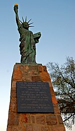
Statue of Liberty
A miniature reproduction of the Statue of Liberty was dedicated in Chimborazo Park on February 11, 1951. A gift to the city by the Boy Scouts of Robert E. Lee Council in 1951, it was part of a nationwide campaign to "Strengthen the Arm of Liberty”. A Missourian, Jack P. Whitaker, conceived the idea of copying the original. He had the original made at his own expense and sold copies to Boy Scout councils throughout the country at cost.
More than 100 statues were distributed (Richmond's was No. 136). A local department store furnished the purchase price of $350 to Mr. Whitaker. Every Boy Scout in the council donated 25 cents, their names going on scrolls which were sealed in the statue's base. A contractor and other workers donated their energies, working on the 11-point-star base and walk which would have cost an estimated $4,000.
The dedication ceremony was presided over by Colonel C. W. Woodson, Jr., superintendent of the Virginia State Police, before Richmond's mayor, T. Nelson Parker ((D) 1950-1952), the John Marshall High School Band, a Boy Scout drum and bugle corps and 3,000 people.[50]
A marker on the statue reads as follows:
With the faith and courage of their forefathers who made possible the freedom of these United States the Boy Scouts of America dedicated this copy of the Statue of Liberty as a pledge of everlasting fidelity and loyalty
40th anniversary crusade to Strengthen the Arm of Liberty 1950
Chimborazo Round House
Comfort Station, Chimborazo Park (1915)
On the east side of the park, overlooking Fulton Bottom, sits the Chimborazo Round House built in 1915. Originally built as a comfort station and park house, it replaced two previous buildings on that site.
The original Chimborazo Pavilion was designed by Edgerton S. Rogers and built in 1905. The pavilion boasted a large veranda, which encircled the building, as well as a bandstand. In order to enhance the attractions of the park for the people of Richmond, city officials promoted the pavilion as a site for popular concerts and public events. The expense of providing music and staffing the refreshment stand led the city to convert the nearby concession stand into a park house to store maintenance tools.
Two years later, both the pavilion and the old concession stand were torn down. The materials from the two structures were used to build a combination comfort station and park house on the site of the original pavilion in 1910.
It is probable that the 1910 structure burned down and was replaced by a new octagonal comfort station and park house, the same structure that stands in the park today.[51]
Chimborazo Fountain
In the center of the park sits a vacant circle where an iron fountain once stood. Drawing water from a spring beneath the park, the Chimborazo Fountain was built in the middle of the park's central circle in 1909. The fountain was wired for electric lighting, and at night colored lights shone from underneath the flowing water. This lighting required the City Engineer to install a series of electrical poles running through the center of the park, significantly detracting from the fountain's grandeur.
In 1910, recognizing this severe design flaw, engineers dismantled the fountain and placed the wires underground. The city also added a handsome iron fence and a concrete walkway surrounding the fountain. The colorful lights of the fountain captivated visitors and neighborhood residents through the first half of the twentieth century.
By 1956, however, the fountain was shrouded in a thick coat of rust and its wiring had deteriorated beyond repair. The fountain was finally removed from Chimborazo Park, leaving the park's central circle vacant.[52]
Related Research Articles
Richmond is the capital city of the Commonwealth of Virginia in the United States. Incorporated in 1742, Richmond has been an independent city since 1871. The city's population in the 2020 census was 226,610, up from 204,214 in 2010, making it Virginia's fourth-most populous city. The Richmond metropolitan area, with 1,260,029 people, is the Commonwealth's third-most populous.
Church Hill, also known as the St. John's Church Historic District, is an Old and Historic District in Richmond, Virginia. This district encompasses the original land plat of the city of Richmond. Church Hill is the eastern terminus of Broad Street, a major east-west thoroughfare in the Richmond metropolitan area. The name Church Hill is often used to describe both the specific historic district and the larger general area in the East End encompassing other neighborhoods such as Union Hill, Chimborazo, Fairmount, Peter Paul, Woodville, etc.
Monument Avenue is a tree-lined grassy mall dividing the eastbound and westbound traffic in Richmond, Virginia, originally named for its emblematic complex of structures honoring those who fought for the Confederacy during the American Civil War. Between 1900 and 1925, Monument Avenue greatly expanded with architecturally significant houses, churches, and apartment buildings. Four of the bronze statues representing J. E. B. Stuart, Stonewall Jackson, Jefferson Davis and Matthew Fontaine Maury were removed from their memorial pedestals amidst civil unrest in July 2020. The Robert E. Lee monument was handled differently as it was owned by the Commonwealth, in contrast with the other monuments which were owned by the city. Dedicated in 1890, it was removed on September 8, 2021. All these monuments, including their pedestals, have now been removed completely from the Avenue. The last remaining statue on Monument Avenue is the Arthur Ashe Monument, memorializing the African-American tennis champion, dedicated in 1996.
Monroe Park is a 7.5 acres (3.0 ha) landscaped park 1 mile (1.6 km) northwest of the Virginia State Capitol Building in Richmond, Virginia. It is named after James Monroe, the fifth president of the United States (1817–1825). The park unofficially demarcates the eastern point of the Fan District and is Richmond's oldest park. It occupies the center of the Virginia Commonwealth University Monroe Park Campus.
The Tredegar Iron Works in Richmond, Virginia, was the biggest ironworks in the Confederacy during the American Civil War, and a significant factor in the decision to make Richmond its capital.
The American Civil War Museum is a multi-site museum in the Greater Richmond Region of central Virginia, dedicated to the history of the American Civil War. The museum operates three sites: The White House of the Confederacy, American Civil War Museum at Historic Tredegar in Richmond, and American Civil War Museum at Appomattox. It maintains a comprehensive collection of artifacts, manuscripts, Confederate books and pamphlets, and photographs.
The White House of the Confederacy is a historic house located in the Court End neighborhood of Richmond, Virginia. Built in 1818, it was the main executive residence of the sole President of the Confederate States of America, Jefferson Davis, from August 1861 until April 1865. It was viewed as the Confederate States counterpart to the White House in Washington, D.C. It currently sits on the campus of Virginia Commonwealth University.
The history of Richmond, Virginia, as a modern city, dates to the early 17th century, and is crucial to the development of the colony of Virginia, the American Revolutionary War, and the Civil War. After Reconstruction, Richmond's location at the falls of the James River helped it develop a diversified economy and become a land transportation hub.
The Greater Richmond, Virginia area has many neighborhoods and districts.
The Virginia State Capitol is the seat of state government of the Commonwealth of Virginia, located in Richmond, the state capital. It houses the oldest elected legislative body in North America, the Virginia General Assembly, first established as the House of Burgesses in 1619.
The Richmond National Battlefield Park commemorates 13 American Civil War sites around Richmond, Virginia, which served as the capital of the Confederate States of America for most of the war. The park connects certain features within the city with defensive fortifications and battle sites around it.
Richmond, Virginia served as the capital of the Confederate States of America during the American Civil War from May 8, 1861, hitherto the capital had been Montgomery, Alabama. Notwithstanding its political status, it was a vital source of weapons and supplies for the war effort, as well as the terminus of five railroads, and as such would have been defended by the Confederate States Army at all costs.
The East End of Richmond, Virginia is the quadrant of the City of Richmond, Virginia, and more loosely the Richmond metropolitan area, east of the downtown.
Chimborazo Hospital was a Civil War-era facility built in Richmond, Virginia to service the medical needs of the Confederate Army. It functioned between 1862 and 1865 in what is now Chimborazo Park, treating over 76,000 injured Confederate soldiers. During its existence, the hospital admitted nearly 78,000 patients and between 6,500 and 8,000 of these patients died. This mortality rate of between 8.3 and 10.3 percent is among the lowest such rates of period military hospitals.
Tree Hill near Richmond, Virginia, in Henrico County, Virginia, is a Greek Revival style plantation house overlooking the James River about two miles east of downtown Richmond near the intersection of the historic Osborne Turnpike and New Market Road. Currently still a private farm, but expected to become partly a park after housing and commercial development, it was once owned by Richmond distiller and landowner Franklin Stearns, a prominent Unionist during the American Civil War. Centuries earlier, it had been a Native American camp site, and the birthplace of powerful chief Powhatan (d.1618).
The following is a timeline of the history of the city of Richmond, Virginia, United States
The "Almshouse", also known as the City Home is a historic almshouse and hospital complex located in Richmond, Virginia.
Libby Hill is a small neighborhood in Richmond, Virginia. Libby Hill is located on the southeastern spur of Church Hill, overlooking the James River and the Lucky Strike building. It is known for Libby Hill Park and "The View that Named Richmond". The Libby Hill neighborhood is entirely within the St. John's Church Historic District.
The Jefferson Davis Memorial was a memorial for Jefferson Davis (1808–1889), president of the Confederate States of America from 1861 to 1865, installed along Richmond, Virginia's Monument Avenue, in the United States. The monument was unveiled on Davis' birthday, June 3, 1907, a day celebrated in Virginia and many other Southern states as Confederate Memorial Day. It consisted of a bronze statue of Davis by Richmond sculptor Edward Valentine surrounded by a colonnade of 13 columns represented the Southern states, and a tall Doric column topped by a bronze statue, also by Valentine, representing Southern womanhood.
↑ Johns, Frank S. and Anne Page Johns, Chimborazo Hospital and J. B. McCaw, Surgeon-in-Chief, The Virginia Magazine of History and Biography, Vol. 62, No. 2 (Apr., 1954), page 192.
↑ Green, Carol C., Chimborazo: The Confederacy's Largest Hospital (2007), pages 7-8. A Richard H. Laughton is listed in the 1850 United States Census living in Henrico County. See 1850 Federal Census
Green, Carol C. Chimborazo: The Confederacy's Largest Hospital (2007)
Pember, Phoebe Yates. 1974. A Southern Woman's Story: Life in Confederate Richmond. (editor B.I. Wiley). Mockingbird Books. ISBN0-345-23865-6 - (Mrs. Yates, a chief matron of one of the hospital divisions at Chimborazo, wrote this memoir between 1865 and 1879. Douglas Southall Freeman regarded this as "one of the most fascinating of Confederate books." Freeman, Douglas Southall, "Lee's Lieutenants," Volume 3, Page 544, footnote).
The Library of Virginia houses a collection of records from the City Engineer's office between 1809 and 1975 which contain numerous architectural drawings and plans related to the round house, fountain and the pavilion. City of Richmond (Va.), Office of the City Engineer, Records. Accession 34886a (Barcode number 1205723) (Folder 39), Local records collection, The Library of Virginia, Richmond, Virginia. See A Guide to the Richmond (Va.) Office of the City Engineer Records, 1809-1975) for additional information.
This page is based on this Wikipedia article Text is available under the CC BY-SA 4.0 license; additional terms may apply. Images, videos and audio are available under their respective licenses.