Chingford Mount is an area of Chingford, eastLondon, England, located in South Chingford. The name refers to the shopping area located around A112/A1009 crossroads (OS Grid Reference TQ373928), though it is also used for the hill leading north from the crossroads to Chingford Old Church. The original name for this hill was Merry Hill or Church Hill.
Many of the buildings were erected in the 1930s to Art Deco designs. The impressive Chingford Odeon cinema, an original Oscar Deutsch building designed by Andrew Mather and opened in September 1935, was demolished in 1972 to make way for a supermarket.
North of the shopping area and opposite the Old Church is Chingford Mount Cemetery. Opened in May 1884, 411⁄2 acres in size, it was laid out on the site of the house and grounds of Caroline Mount. Among those buried in the cemetery are the Kray twins and other members of their family. The cemetery contains the war graves of 137 Commonwealth service personnel of World War I and 182 of World War II, with the names of those whose graves have no headstones being listed on a low screen wall surrounding the War Graves Plot in Section F13.[1]
Until the 1850s, this part of Chingford was solely farmland, with Cherrydown Farm to the north of the crossroads and Normanshire Farm to the south of it. In the second half of the nineteenth century, the Prince Albert Inn was built at the crossroads. Though cottages and houses were later built along Old Church Hill, shops only began to appear once the tramway was extended to the Albert Corner in 1904. The name was firmly established by 1923, when the section of Chingford Road from the Chingford-Walthamstow boundary to the crossroads was renamed Chingford Mount Road.
Chingford is a town in east London, England, within the London Borough of Waltham Forest. The centre of Chingford is 9.2 miles (14.8 km) north-east of Charing Cross, with Waltham Abbey to the north, Woodford Green and Buckhurst Hill to the east, Walthamstow to the south, and Edmonton and Enfield to the west. The town contains the areas of Chingford Green, Chingford Hatch, Chingford Mount, Friday Hill, Hale End, Highams Park, and South Chingford, and had a population of 70,583 at the 2021 census.
West Norwood is a largely residential area of south London within the London Borough of Lambeth, located 5.4 miles (8.7 km) south south-east of Charing Cross. The centre of West Norwood sits in a bowl surrounded by hillsides on its east, west and south sides. From many parts of the area, distant views can be seen, of places such as the City of London, Canary Wharf and Crystal Palace.
Eston is an industrial town in the borough of Redcar and Cleveland, North Yorkshire, England. The ward covering the area had a population of 7,005 at the 2011 census. It is part of Greater Eston, which includes the outlying settlements of Grangetown, Normanby, South Bank, Teesville and part of Ormesby.
Lee, also known as Lee Green, is an area of South East London, England, straddling the border of the London Borough of Lewisham and the Royal Borough of Greenwich. It is located northwest of Eltham and southeast of Lewisham. It is within the historic county of Kent.
Carterton is a town in West Oxfordshire district in the county of Oxfordshire, England and is 4 miles (6.4 km) south-west of Witney. The 2011 Census recorded the parish's population as 15,769.
St. Clair Avenue is a major east-west street in Toronto, Ontario, Canada. It was laid out in the late 18th century by the British as a concession road, 2 kilometres (1.2 mi) north of Bloor Street and 4 kilometres (2.5 mi) north of Queen Street.
Blacon is a council estate on the outskirts of Chester, England. It was once one of the largest council housing estates in Europe.
Blidworth is a village and civil parish approximately five miles east of Mansfield, Nottinghamshire, England. The population of the civil parish at the 2011 census was 4,457. Its history can be traced back to the 10th century, although many of the current houses were built in the first half of the 20th century to provide housing for workers at Blidworth Colliery (1926–1989). These are mainly in estates north of Dale Lane, known as New Blidworth. The area around Main Street, west of Beck Lane and including the church, is Old Blidworth, containing some of the oldest buildings. Blidworth Bottoms is a hamlet about 0.5 km south of Old Blidworth.
Whitwick is a large village in Leicestershire, England, close to the town of Coalville in the northwest of the county. It lies in an ancient parish which formerly included the equally historic villages of Thringstone and Swannington. It was an important manor in the Middle Ages, which once included Bardon and Markfield, parts of Hugglescote, Donington le Heath, Ratby, Bocheston, Newtown Unthank and Whittington. As early as 1293, Whitwick had a weekly market and a four-day fair. The population of Whitwick, according to the 2001 census was 10,815 persons. 8,092 of these fell into the 16-74 working age range, although only 4,689 were employed. The population of the village at the 2011 census had fallen to 8,612.
Prestwich is a town in the Metropolitan Borough of Bury, Greater Manchester, England, 3.3 miles (5.3 km) north of Manchester city centre, 3.1 miles (5 km) north of Salford and 4.7 miles (7.6 km) south of Bury.
Edmonton is a town in north London, England within the London Borough of Enfield, a local government district of Greater London. The northern part of the town is known as Lower Edmonton or Edmonton Green, and the southern part as Upper Edmonton. Situated 8.4 miles (13.5 km) north-northeast of Charing Cross, it borders Enfield to the north, Chingford to the east, and Tottenham to the south, with Palmers Green and Winchmore Hill to the west. The population of Edmonton was 82,472 as of 2011.
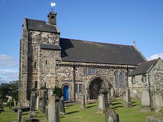
Kirkliston is a small town and parish to the west of Edinburgh, Scotland, historically within the county of West Lothian but now within the City of Edinburgh council limits. It lies on high ground immediately north of a northward loop of the Almond, on the old road between Edinburgh and Linlithgow, having a crossroads with the road from Newbridge to Queensferry and beyond to Fife. The B800 is variously named Path Brae, High Street, Station Road, and Queensferry Road as it passes through the town. The B9080 is named Main Street and Stirling Road as it passes through.
Stonehouse is a rural village in South Lanarkshire, Scotland. It is on Avon Water in an area of natural beauty and historical interest, near to the Clyde Valley. It is on the A71 trunk road between Edinburgh and Kilmarnock, near the towns of Hamilton, Larkhall and Strathaven. The population of Stonehouse is around 7,500.
Redditch is a town and local government district in north-east Worcestershire, England. The town is divided into separate districts. All street-name signs in Redditch have the street name in white lettering on a blue background and the district name in black lettering on a white background at the bottom of the sign. In the New Town areas the roads are usually named in alphabetical order and house numbering in the cul-de-sac closes is consecutive, starting with number 1 as the first house on the left as you enter, and the highest house number will be on the opposite side of the road as you leave.
The English coastal city of Brighton and Hove, made up of the formerly separate Boroughs of Brighton and Hove in East Sussex, has a wide range of cemeteries throughout its urban area. Many were established in the mid-19th century, a time in which the Victorian "cult of death" encouraged extravagant, expensive memorials set in carefully cultivated landscapes which were even recommended as tourist attractions. Some of the largest, such as the Extra Mural Cemetery and the Brighton and Preston Cemetery, were set in particularly impressive natural landscapes. Brighton and Hove City Council, the local authority responsible for public services in the city, manages seven cemeteries, one of which also has the city's main crematorium. An eighth cemetery and a second crematorium are owned by a private company. Many cemeteries are full and no longer accept new burials. The council maintains administrative offices and a mortuary at the Woodvale Cemetery, and employs a coroner and support staff.
Laverstock is a village and civil parish on the north-east and east outskirts of Salisbury in the ceremonial county of Wiltshire, England. The parish is shaped like a figure 7 and incorporates Ford hamlet, the eastern half of the former manor of Milford, the area near the ancient settlement of Old Sarum, and part of the Hampton Park district on the edge of Salisbury.
The Bear Road area is a largely residential area in the east of Brighton, part of the English city of Brighton and Hove. Centred on the steep west–east road of that name, it is characterised by terraced houses of the early 20th century, but Brighton's main cemeteries were established here in the 19th century and there is also some industry.
Chingford Mount Cemetery is a cemetery in Chingford Mount, in the London Borough of Waltham Forest.
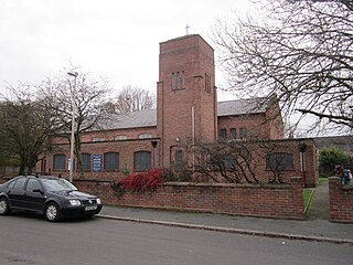
Christ Church Barnet, is a Church of England church in St Albans Road, Chipping Barnet.
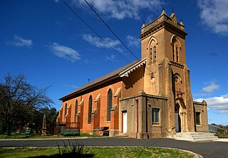
Holy Trinity Anglican Church is a heritage-listed Anglican church precinct, containing the church, rectory and adjacent cemetery, at 71-85 Gilmour Street, Kelso, Bathurst Region, New South Wales, Australia. The church was built from 1833 to 1878, with John Foster being responsible for the building of the original church. Edmund Blacket designed the rectory. The property is owned by Anglican Property Trust Diocese of Bathurst and Parish of Kelso, Anglican Diocese of Bathurst. It was added to the New South Wales State Heritage Register on 14 January 2011.
This page is based on this Wikipedia article Text is available under the CC BY-SA 4.0 license; additional terms may apply. Images, videos and audio are available under their respective licenses.