Chipoka

Last updated
Chipoka
Malawi adm location map.svg
Red pog.svg
Chipoka
Location in Malawi
Coordinates: 13°58′S34°30′E / 13.967°S 34.500°E / -13.967; 34.500
Country Flag of Malawi.svg  Malawi
Region Central Region
District Salima District
Population
 (2018 Census [1] )
  Total6,395
Climate Aw

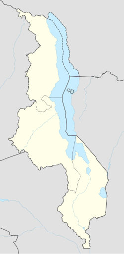
Chipoka is a town located in the Central Region district of Salima, in Malawi. It is one of the main ports on Lake Malawi and is the closest port to the capital city of Lilongwe. Chipoka is located on the western shore of Kasangha Bay across from Cape Maclear.

Nearby towns and villages include Chaseta (7.8 mi (12.6 km)), Ndembo (7.7 mi (12.4 km)), Kalombola (5.6 mi (9.0 km)), Lowe (5.6 mi (9.0 km)), Mazenjele (5.6 mi (9.0 km)), Chikanda (4.9 mi (7.9 km)), Milala (4.9 mi (7.9 km)), Mkangawi (4.9 mi (7.9 km)), Mzembela (4.9 mi (7.9 km)), Pemba (4.9 mi (7.9 km)) and Kachindamoto(11.7 mi (18.8 km)).

The city has a railway station on the Sena railway, part of the Malawi Railways.

Demographics

YearPopulation [2] [1]
19983,986
20085,476
20186,395

Related Research Articles

Transport in Mozambique

Modes of transport in Mozambique include rail, road, water, and air. There are rail links serving principal cities and connecting the country with Malawi, Zimbabwe and South Africa. There are over 30,000km of roads, but much of the network is unpaved.

Pooler, Georgia City in Georgia, United States

Pooler is a city in Chatham County, Georgia, United States. According to the official 2010 U.S. Census, the population was 19,140, a threefold increase over the 2000 count of 6,239. The 2019 population estimate was 25,694. Pooler is located northwest of Savannah along Interstates 95 and 16. It comprises part of the Savannah metropolitan area.

Junction City, Georgia Town in Georgia, United States

Junction City is a town in Talbot County, Georgia, United States. The population was 179 at the 2000 census.

Mount Vernon, Indiana City in Indiana, United States

Mount Vernon is a city in and the county seat of Posey County, Indiana, United States. Located in the state's far southwestern corner, within 15 miles (24 km) of both the southernmost or westernmost points, it is the westernmost city in the state. The southernmost is Rockport, located along the Ohio River about 40 miles (64 km) to the southeast.

Raceland, Kentucky City in Kentucky, United States

Raceland is a home rule-class city in Greenup County, Kentucky, United States, in the Ohio River valley. As of the 2010 census, the population was 2,424.

Savage, Minnesota City in Minnesota, United States

Savage is a suburban city 15 miles (24 km) south-southwest of downtown Minneapolis in Scott County in the State of Minnesota. The city is situated on the south bank of the Minnesota River in a region commonly referred to as South of the River, comprising the southern portion of Minneapolis-St. Paul, the sixteenth largest metropolitan area in the United States. The population of Savage was 26,911 at the 2010 census.

Mayville, North Dakota City in North Dakota, United States

Mayville is a city in Traill County, North Dakota, United States. The population was 1,858 at the 2010 census, which makes Mayville the largest community in Traill County. Mayville was founded in 1881. The city's name remembers May Arnold, the first white child born in the immediate area.

Hamilton, Texas City in Texas, United States

Hamilton is a city in and the county seat of Hamilton County, Texas, United States, located in the state's central region. Its population was 3,095 at the 2010 census.

Ore City, Texas City in Texas, United States

Ore City is a city in Upshur County, Texas, United States. The population was 1,144 at the 2010 census.

Adams, Wisconsin City in Wisconsin, United States

Adams is a city in Adams County in the U.S. state of Wisconsin. The population was 1,967 at the 2010 census. The city is located within the Town of Adams.

Hokkaido Railway Company Japanese railway company

The Hokkaido Railway Company is one of the constituent companies of the Japan Railways Group, and is often referred to using its official abbreviation of JR Hokkaido. It operates intercity and local rail services in Hokkaido, Japan. The company introduced Kitaca, a smart card ticketing system, in autumn 2008.

Blantyre Place in Southern Region, Malawi

Blantyre is Malawi's centre of finance and commerce, and its second largest city, with an enumerated 800,264 inhabitants as of 2018. It is sometimes referred to as the commercial and industrial capital of Malawi as opposed to the political capital, Lilongwe. It is the capital of the country's Southern Region as well as the Blantyre District.

Monkey Bay Place in Southern Region, Malawi

Monkey Bay or Lusumbwe is a town in Mangochi which is in the Mangochi District in the Southern Region of Malawi. The town is on the shore of Lake Malawi and is one of the main ports on Lake Malawi. The population of Monkey Bay was 14,955 according to the 2018 census. Monkey Bay is 206 kilometres (128 mi) from Lilongwe, Malawi's capital city, and 253 kilometres (157 mi) from Blantyre. Monkey Bay is a tourist resort and is often travelled through on the road to Cape Maclear.

This article lists extreme locations on Earth that hold geographical records or are otherwise known for their geophysical or meteorological superlatives. All of these locations are Earth-wide extremes; extremes of individual continents or countries are listed in separate articles under the Extreme points by region section. For other lists of extreme places on Earth, see Lists of extreme points. For more detailed meteorological and climatic records, see List of weather records.

Tororo Place in Eastern Region of Uganda, Uganda

Tororo is a town in the Eastern Region of Uganda. It is the main municipal, administrative, and commercial center of Tororo District. There are many shops, banks, supermarkets here. Tororo is a trading hub where many people come from the surrounding villages to work. There are a number of ATM's around town with one at Absa Bank accepting all major cards. MTN and Airtel mobile agents are throughout the town.there are a number of places of worship Destiny Family Church adjacent to Tororo Main Hospital is a Pentecostal Church.

Ntcheu District District of Malawi

Ntcheu is a district in the Central Region of Malawi. It borders with the country of Mozambique. The district headquarters is Ntcheu, known as BOMA in the local language, but is most commonly called Mphate. It is run by Yeneya, the village headman. The district covers an area of 3,424 km.² and has a population of 659,608 people according to the 2018 Malawi Population and Housing Census. The Ntcheu district lies around halfway between Malawi's majors cities of Blantyre and Lilongwe - the capital city.

Chikwawa is a town with a population of 6,114 according to the 2018 census located in the Southern Region of Malawi on the west bank of the Shire River. It is the administrative capital of the Chikwawa District. Chikwawa lies almost 50 kilometres (30 mi) south of Blantyre, the commercial capital of Malawi.

Dondo District District in Sofala, Mozambique

Dondo District is a district of Sofala Province in Mozambique. The principal town is Dondo. The district is located in the center of the province, and borders with Muanza District in the north, the city of Beira and Buzi District in the south, and with Nhamatanda District in the west. In the east, the district is limited by the Indian Ocean. The area of the district is 2,306 square kilometres (890 sq mi). It has a population of 142,387 as of 2007.

History of rail transport in Malawi

The history of rail transport in Malawi began shortly after the turn of the twentieth century.

Sena railway

Sena railway, also called Shire Highlands railway, Dondo-Malawi railway and North-South Malawi railway, is a railway that connects Dondo, Mozambique, to Chipata, in Zambia. It is c. 1000 km long, in a 1067 mm gauge.

References

  1. 1 2 "2018 Population and Housing Census Main Report" (PDF). Malawi National Statistical Office. Retrieved 25 December 2019.
  2. World Gazetteer: Malawi: largest cities and towns and statistics of their population Archived September 27, 2007, at the Wayback Machine

Coordinates: 13°58′S34°30′E / 13.967°S 34.500°E / -13.967; 34.500