Chota, Peru

Last updated
Chota
Town
Catedral de Chota.jpg
Cathedral of Chota
Peru location map.svg
Red pog.svg
Chota
Coordinates: 6°33′41″S78°38′55″W / 6.56139°S 78.64861°W / -6.56139; -78.64861
CountryFlag of Peru.svg  Peru
Region Cajamarca
Province Chota
District Chota
Government
  MayorWerner Cabrera Campos
Area
  Total392.47 km2 (151.53 sq mi)
Elevation
2,388 m (7,835 ft)
Population
 (2017)
  Total47,279
  Density120/km2 (310/sq mi)
Time zone UTC-5 (PET)

Chota is a town in Northern Peru, capital of the province Chota in the region Cajamarca. The city is the seat of the Territorial Prelature of Chota.

Contents

History

Pre-Spanish history

Chota's history dates back to pre-Inca times; it was a part of the Cajamarca kingdom. The local region has various archaeological remains which suggest that the area supported a dense population. Additionally, locations such as Pacopampa, Negropampa, Rejopampa and others are evidence of influence by the Chavin, Wari and Moche cultures. At various times it was also occupied by cultures such as Los Huambos in the west and Cuismanco in the east. In the mid-15th century, Túpac Yupanqui assimilated the area into the Inca empire.

The city of Chota was first founded as "All Saints of Chota" on 1 November 1552 by Father Juan Ramírez; it is located south-west of present-day Chota. [1]

From Spanish colonization

During the War of the Pacific, after the Battle of San Pablo the Araucanian (from the city of Arauco) entered Chota, to which the people decided to poison the waters of the river Colpamayo and by that the Chilean ordered the burning of the city.

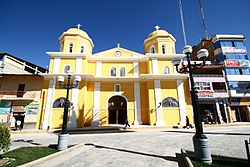
On August 29, 1882, Chota was burned by Chilean troops in retaliation for the defeat they suffered in San Pablo and consider it as the headquarters of the North. Thousands of homes fell, the church was also burned, saving the image of the Patroness, Mary Immaculate, whose dogma was proclaimed on December 8.

Geography

Chota is located 150 km (93 mi) north of Cajamarca and 215 km (134 mi) east of Chiclayo. It lies at 2,388 m (7,835 ft) above sea level on the Acunta plateau, on the eastern slope of the Andes. The city is bounded on three sides by rivers of the westernmost Amazon basin: to the north is the San Mateo, to the east the Colpamayo. Both flow broadly westward into the Rio Chotano, which forms Chota's south-western boundary.

Climate

The city generally has a temperate climate. The rainfalls are due to El Niño cyclically because of the proximity to the Equator and for being a city in thermal ground floor. It has a mild winter and a hot and rainy summer from November to April. The average temperature is 17.8 °C.

Festivals

The main festival of the city is the San Juan Bautista festival. It starts on June 13 with the triumphal entry in a procession, bearing to June 24 as the central day. The activities that are carried out are:

Related Research Articles

<span class="mw-page-title-main">Diego de Almagro</span> Spanish conquistador (1475–1538)

Diego de Almagro, also known as El Adelantado and El Viejo, was a Spanish conquistador known for his exploits in western South America. He participated with Francisco Pizarro in the Spanish conquest of Peru. While subduing the Inca Empire he laid the foundation for Quito and Trujillo as Spanish cities in present-day Ecuador and Peru respectively. From Peru, Almagro led the first Spanish military expedition to central Chile. Back in Peru, a longstanding conflict with Pizarro over the control of the former Inca capital of Cuzco erupted into a civil war between the two bands of conquistadores. In the battle of Las Salinas in 1538, Almagro was defeated by the Pizarro brothers and months later he was executed.

<span class="mw-page-title-main">Francisco Pizarro</span> 16th-century Spanish conquistador who conquered Peru

Francisco Pizarro, Marquess of the Atabillos was a Spanish conquistador, best known for his expeditions that led to the Spanish conquest of the Inca Empire.

<span class="mw-page-title-main">Lima</span> Capital and largest city of Peru

Lima is the capital and largest city of Peru. It is located in the valleys of the Chillón, Rímac and Lurín Rivers, in the desert zone of the central coastal part of the country, overlooking the Pacific Ocean. The city is considered the political, cultural, financial and commercial center of Peru. Due to its geostrategic importance, the Globalization and World Cities Research Network has categorized it as a "beta" tier city. Jurisdictionally, the metropolis extends mainly within the province of Lima and in a smaller portion, to the west, within the Constitutional Province of Callao, where the seaport and the Jorge Chávez Airport are located. Both provinces have regional autonomy since 2002.

<span class="mw-page-title-main">Atahualpa</span> Last Inca Emperor (ruled 1532–1533)

Atahualpa, also Atawallpa (Quechua), Atabalica, Atahuallpa, Atabalipa, was the last effective Incan emperor before his capture and execution during the Spanish conquest.

<span class="mw-page-title-main">Huayna Capac</span> Sapa Inca of the Inca Empire

Huayna Capac was the third Sapa Inca of Tawantinsuyu, the Inca Empire. He was the son of and successor to Túpac Inca Yupanqui., the sixth Sapa Inca of the Hanan dynasty, and eleventh of the Inca civilization. He was born in Tumipampa and tutored to become Sapa Inca from a young age.

<span class="mw-page-title-main">Cajamarca</span> Place in Peru

Cajamarca, also known by the Quechua name, Kashamarka, is the capital and largest city of the Cajamarca Region as well as an important cultural and commercial center in the northern Andes. It is located in the northern highlands of Peru at approximately 2,750 m (8,900 ft) above sea level in the valley of the Mashcon river. Cajamarca had an estimated population of about 226,031 inhabitants in 2015, making it the 13th largest city in Peru.

<span class="mw-page-title-main">Department of Apurímac</span> Departments of Peru

Apurímac is a department and region in southern-central Peru. It is bordered on the east by the Cusco Region, on the west by the Ayacucho Region, and on the south by the Arequipa and Ayacucho regions. The region's name originates from the Quechua language and means "where the gods speak" in reference to the many mountains of the region that seem to be talking to each other.

<span class="mw-page-title-main">Department of Cajamarca</span> Department and region in Peru

Cajamarca is a department and region in Peru. The capital is the city of Cajamarca. It is located in the north part of the country and shares a border with Ecuador. The city has an elevation of 2,700 metres (8,900 ft) above sea level in the Andes Mountain Range, the longest mountain range in the world. Part of its territory includes the Amazon Rainforest, the largest in the world.

<span class="mw-page-title-main">Department of La Libertad</span> Department in 12 provinces and 83 districts, Peru

La Libertad is a region in northwestern Peru. Formerly it was known as the Department of La Libertad. It is bordered by the Lambayeque, Cajamarca and Amazonas regions on the north, the San Martín Region on the east, the Ancash and Huánuco regions on the south and the Pacific Ocean on the west. Its capital is Trujillo, which is the nation's third biggest city. The region's main port is Salaverry, one of Peru's largest ports. The name of the region is Spanish for "freedom" or "liberty"; it was named in honor of the Intendencia of Trujillo's proclaiming independence from Spain in 1820 and fighting for that. It is the ninth smallest department in Peru, but it is also its second-most populous department after Piura and its second-most densely populated department after Lambayeque.

<span class="mw-page-title-main">Spanish conquest of the Inca Empire</span> Period of the Spanish conquest in South America

The Spanish conquest of the Inca Empire, also known as the Conquest of Peru, was one of the most important campaigns in the Spanish colonization of the Americas. After years of preliminary exploration and military skirmishes, 168 Spanish soldiers under conquistador Francisco Pizarro, along with his brothers and their indigenous allies, captured the Sapa Inca Atahualpa in the 1532 Battle of Cajamarca. It was the first step in a long campaign that took decades of fighting but ended in Spanish victory in 1572 and colonization of the region as the Viceroyalty of Peru. The conquest of the Inca Empire, led to spin-off campaigns into present-day Chile and Colombia, as well as expeditions to the Amazon Basin and surrounding rainforest.

Jaén is a city which is the capital of the Jaén Province in the Cajamarca Region in Peru, located in the high jungle of northern Peru. It is the seat of the Catholic Apostolic Vicariate of St. Francis Xavier, also known as Apostolic Vicariate of Jaén en Peru.

<span class="mw-page-title-main">Jauja</span> Town and municipality in Junín, Peru

Jauja is a city and capital of Jauja Province in Peru. It is situated in the fertile Mantaro Valley, 45 kilometres (28 mi) to the northwest of Huancayo, at an altitude of 3,400 metres (11,200 ft). Its population in 2015 was 15,432.

<span class="mw-page-title-main">Bullring</span> Arena where bullfighting is performed

A bullring is an arena where bullfighting is performed. Bullrings are often associated with the Iberian Peninsula, but they can also be found through Iberian America and in a few Spanish and Portuguese ex-colonies in Africa. Bullrings are often historic and culturally significant centres that bear many structural similarities to the Roman amphitheatre.

<span class="mw-page-title-main">Plaza de toros de Acho</span> Bull ring and cultural heritage site in Peru

The Plaza de Torosde Acho is the premier bullring in Lima, Peru. Located beside the historical center of the Rímac District, the plaza is classified as a national historic monument. It is the oldest bullring in the Americas and the second-oldest in the world after La Maestranza in Spain. It opened on 30 January 1766.

<span class="mw-page-title-main">Miguel Iglesias</span> President of Peru from 1883 to 1885

Miguel Iglesias Pino de Arce was born on 11 June 1830 in Cajamarca, Peru, and died on 7 November 1909 in Lima, Peru. He was a Peruvian soldier, general, and politician who served as the 26th President of Peru from 1882 to 1885.

<span class="mw-page-title-main">Leimebamba District</span> District in Amazonas, Peru

Leimebamba is a district of the province of Chachapoyas, located in the northern Peruvian department of Amazonas, in the valley of the Utcubamba River, about 60 kilometers south of Chachapoyas.

Choropampa District is one of nineteen districts of the Chota Province, Peru. It is located in the Northern Peruvian highlands and renowned for its gold reserves, with South Americas largest goldmine operations.

Chota District is one of nineteen districts in the Chota Province in Peru. It is located in the central part of the province in the northern Andean region of Peru. Its capital is located on the plateau of Acunto at 2,388 meters above sea level and 150 km north of Cajamarca, or 219 km east of Chiclayo, Lambayeque.

Pimpingos District is one of fifteen districts of the Cutervo Province in the Cajamarca Region in Peru. It was created on 22 October 1910 by Law No. 1296. It is one of the oldest districts of the province.

<span class="mw-page-title-main">Bullfighting</span> Physical contest involving a bullfighter and a bull

Bullfighting is a physical contest that involves a bullfighter attempting to subdue, immobilize, or kill a bull, usually according to a set of rules, guidelines, or cultural expectations.

References

  1. "Breve Reseña Histórica De Chota". Carlos Alberto Vigil Vásquez (in Latin American Spanish). Segundo Wilson Pérez Medina. 2006. Retrieved 25 October 2023.