Christiansted, U.S. Virgin Islands

Last updated
Christiansted, U.S. Virgin Island
Town
Town of Christiansted
Christiansted-1-.jpg
The City of Christiansted looking east
United States Virgin Islands Saint Croix location map.svg
Red pog.svg
Christiansted
Coordinates: 17°45′N64°45′W / 17.75°N 64.75°W / 17.75; -64.75
Sovereign StateFlag of the United States (23px).png  United States
TerritoryFlag of the United States Virgin Islands.svg  Virgin Islands
Island Saint Croix
EstablishedSeptember 1, 1734
Population
 (2020)[ citation needed ]
  Total1,866
ZIP code(s)
00820–00824

Christiansted is the largest town on Saint Croix, one of the main islands composing the United States Virgin Islands, a territory of the United States of America. The town is named after King Christian VI of Denmark. [1]

Contents

History

Christiansted in 1825 Hans Peter Thorsoe - Christiansted - 1825.jpg
Christiansted in 1825
Christiansted in 1831 Christiansted seen from Peters Farm.jpg
Christiansted in 1831

The town was founded by Captain Frederik Moth after he was made governor of St. Croix in 1733. Departing from St. Thomas, Moth's party had cleared a space for Fort Christianswærn by 5 September. In a ceremony next to this fort on 8 January 1734, the French formally handed the island over to the Danes in the form of the Danish West India and Guinea Company. St. Croix was to be allotted 300 plantations, 215 for sugar and the rest for cotton. The plantations surveyed were 3,000 by 2,000 feet. In addition, the company established a sugar refinery and distillery. The fort was completed by 1740. The 1742 census listed 120 sugar plantations, 122 cotton plantations, 1,906 slaves, about 300 Englishmen, and 60 Danes. By 1743, St. Croix had a hospital. In 1745, the number of slaves had increased to 2,878. By 1754, the town included 83 "white inhabitants", "each of whom owned from a single slave to sixty-six of them", according to Westergaard. Slaves on the island numbered 7,566. [2]

Christiansted is a former capital of the Danish West Indies and home to the Christiansted National Historic Site. It has preserved the 18th-century Danish-style solid stone buildings in pastel colors with bright red tile roofs line the cobblestone sidewalks, adding a touch of 18th-century European architectural style. Because the town was constructed by African slaves, there are also African influences in Christiansted's design, making it one of the world's few "African-Danish" towns. The town's symmetry, with streets running at right angles to the waterfront, makes it popular for walking tours. The commercial area centers on King and Company streets, adjacent to the Christiansted National Historic Site. The residential area, including portions that were originally settlements for free blacks, extends inland and uphill from the commercial area. The botanist Julius von Rohr started a botanic garden in the 18th century and produced a number of landscapes of the island.

Christiansted has small hotels and many restaurants. In 1947, The Buccaneer resort, to the northeast of town, was opened by the Armstrong family as an 11-room inn. [3] Several scuba shops operate in town, as the wharf has easy access to diving attractions on the island's north side. A small point of interest is Protestant Cay, a cay near Christiansted.

Queens Cross St. in Christiansted Queen CrossSt 20230924 115910.jpg
Queens Cross St. in Christiansted

Demographics

As of 2020, Christiansted had a population of 1,770, while the larger sub-district had a population of 1,866.

The population decreased by almost 30% between 2010 and 2020 due to the impact of Hurricanes Irma and Maria. [4]

Population history of Christiansted subdistrict
YearPop.±%
1990 3,199    
2000 2,865−10.4%
2010 2,626−8.3%
2020 1,866−28.9%
Source: US Census Bureau [5] [6]

Economy

Christiansted The Boardwalk (22723663183).jpg
Christiansted

Seaborne Airlines was formerly headquartered in Christiansted. [7]

Transportation

Christiansted is served by one commercial airport, Henry E. Rohlsen Airport, with flights on several airlines, including American and Delta. A ferry serving the Hotel on the Cay resort runs between Christiansted and Protestant Cay.

Education

Public schools serving the community are operated by the St. Croix School District.

Climate

Christiansted has a tropical savanna climate (Koppen Aw/As).

Climate data for Christiansted, U.S. Virgin Islands (Henry E. Rohlsen International Airport) (1991–2020 normals, extremes 1951–present)
MonthJanFebMarAprMayJunJulAugSepOctNovDecYear
Record high °F (°C)92
(33)
93
(34)
92
(33)
93
(34)
94
(34)
97
(36)
94
(34)
96
(36)
97
(36)
98
(37)
93
(34)
92
(33)
98
(37)
Mean maximum °F (°C)86.3
(30.2)
87.0
(30.6)
87.3
(30.7)
88.3
(31.3)
89.1
(31.7)
91.0
(32.8)
91.6
(33.1)
92.0
(33.3)
91.4
(33.0)
90.8
(32.7)
89.3
(31.8)
87.7
(30.9)
92.7
(33.7)
Mean daily maximum °F (°C)84.2
(29.0)
84.6
(29.2)
85.0
(29.4)
86.0
(30.0)
87.1
(30.6)
88.7
(31.5)
89.2
(31.8)
89.5
(31.9)
89.0
(31.7)
88.4
(31.3)
86.8
(30.4)
85.1
(29.5)
87.0
(30.6)
Daily mean °F (°C)77.7
(25.4)
78.0
(25.6)
78.2
(25.7)
79.7
(26.5)
81.2
(27.3)
82.8
(28.2)
83.2
(28.4)
83.4
(28.6)
82.8
(28.2)
82.2
(27.9)
80.6
(27.0)
78.8
(26.0)
80.7
(27.1)
Mean daily minimum °F (°C)71.2
(21.8)
71.4
(21.9)
71.5
(21.9)
73.4
(23.0)
75.4
(24.1)
76.9
(24.9)
77.3
(25.2)
77.4
(25.2)
76.6
(24.8)
76.0
(24.4)
74.4
(23.6)
72.5
(22.5)
74.5
(23.6)
Mean minimum °F (°C)66.7
(19.3)
66.9
(19.4)
66.9
(19.4)
68.2
(20.1)
70.6
(21.4)
72.4
(22.4)
73.2
(22.9)
73.6
(23.1)
73.1
(22.8)
72.6
(22.6)
69.4
(20.8)
68.3
(20.2)
64.4
(18.0)
Record low °F (°C)61
(16)
61
(16)
60
(16)
62
(17)
62
(17)
62
(17)
64
(18)
63
(17)
63
(17)
65
(18)
61
(16)
61
(16)
60
(16)
Average precipitation inches (mm)1.94
(49)
1.35
(34)
1.62
(41)
2.22
(56)
3.62
(92)
1.92
(49)
2.64
(67)
3.23
(82)
4.89
(124)
5.03
(128)
5.30
(135)
3.25
(83)
37.01
(940)
Average precipitation days (≥ 0.01 in)15.812.612.010.211.911.316.715.615.716.916.817.2172.7
Source: NOAA [8] [9]

Notable people

Notes

  1. "The Port of Christiansted". U.S. National Park Service.
  2. Westergaard, Waldemar (1917). The Danish West Indies Under Company Rule (1671-1754). New York: The Macmillan Company. pp.  209–217, 222–225, 235.
  3. "Historic Hotels of America adds the Buccaneer on St. Croix". Travel Weekly. 8 November 2006. Retrieved 7 December 2023.
  4. "Slow Road to Recovery: U.S.V.I. Sees Signs of Resilience Amid Range of Difficulties". U.S.V.I.'s population fell by 18 percent between 2010 and 2020. Factors driving that decline include the closing of an oil refinery that had been the territory's largest private employer, destruction caused by Hurricanes Irma and Maria, job losses in the tourism sector, a high cost of living, and a lack of educational opportunities.
  5. "Population of the United States Virgin Islands: 2010 and 2020" (PDF).
  6. "Census Bureau Releases Census 2000 Population Counts for the U.S. Virgin Islands".
  7. "Contact Seaborne Airlines" (). Seaborne Airlines. February 7, 2006. Retrieved on April 18, 2015. "Postal Address: Seaborne Airlines Attn: Feedback 34 Strand Street Christiansted, VI 00820 "
  8. "NowData – NOAA Online Weather Data". National Oceanic and Atmospheric Administration. Retrieved June 17, 2021.
  9. "Station: Christiansted AP, VI VQ". U.S. Climate Normals 2020: U.S. Monthly Climate Normals (1991–2020). National Oceanic and Atmospheric Administration. Retrieved June 17, 2021.

Related Research Articles

<span class="mw-page-title-main">United States Virgin Islands</span> Territory of the United States

The United States Virgin Islands, officially the Virgin Islands of the United States, are a group of Caribbean islands and an unincorporated and organized territory of the United States. The islands are geographically part of the Virgin Islands archipelago and are located in the Leeward Islands of the Lesser Antilles.

<span class="mw-page-title-main">Economy of the United States Virgin Islands</span>

The economy of the United States Virgin Islands is primarily dependent upon tourism, trade, and other services, accounting for nearly 60% of the Virgin Island's GDP and about half of total civilian employment. Close to two million tourists per year visit the islands. The government is the single largest employer. The agriculture sector is small, with most food being imported. The manufacturing sector consists of rum distilling, electronics, pharmaceuticals, and watch assembly. Rum production is significant. Shipments during a six-month period of fiscal year 2016 totaled 8,136.6 million proof gallons.

<span class="mw-page-title-main">Danish West Indies</span> Former Danish colony in the Caribbean

The Danish West Indies or Danish Virgin Islands or Danish Antilles were a Danish colony in the Caribbean, consisting of the islands of Saint Thomas with 32 square miles (83 km2); Saint John with 19 square miles (49 km2); and Saint Croix with 84 square miles (220 km2). The islands have belonged to the United States as the Virgin Islands since they were purchased in 1917. Water Island was part of the Danish West Indies until 1905, when the Danish state sold it to the East Asiatic Company, a private shipping company.

<span class="mw-page-title-main">Charlotte Amalie, U.S. Virgin Islands</span> Capital city of the United States Virgin Islands

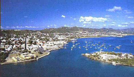
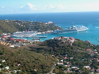
Charlotte Amalie, located on St. Thomas, is the capital and the largest city of the United States Virgin Islands. It was founded in 1666 as Taphus. In 1691, the town was renamed to Charlotte Amalie after the Danish queen Charlotte Amalie of Hesse-Kassel (1650–1714). It has a deep-water harbor that was once a haven for pirates and is now one of the busiest ports of call for cruise ships in the Caribbean, with about 1.5 million-plus cruise ship passengers landing there annually. Protected by Hassel Island, the harbor has docking and fueling facilities, machine shops, and shipyards and was a U.S. submarine base until 1966. The Town has been inhabited for centuries. When Christopher Columbus arrived in 1493, the area was inhabited by Caribs, Arawaks, Ciboney and Taíno native peoples. It is on the southern shore at the head of Saint Thomas Harbor. In 2010 the City had a population of 18,481, which makes it the largest city in the Virgin Islands Archipelago. Hundreds of ferries and yachts pass by the Town each week.

Saint Croix is an island in the Caribbean Sea, and a county and constituent district of the United States Virgin Islands (USVI), an unincorporated territory of the United States.

<span class="mw-page-title-main">Saint Thomas, U.S. Virgin Islands</span> One of the main islands of the U.S. Virgin Islands

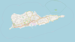
Saint Thomas is one of the Virgin Islands in the Caribbean Sea, and a constituent district of the United States Virgin Islands (USVI), an unincorporated territory of the United States. Along with surrounding minor islands, it is one of three county-equivalents in the USVI. Together with Saint John, it forms one of the districts of the USVI. The territorial capital and port of Charlotte Amalie is located on the island. As of the 2020 census, the population of Saint Thomas was 42,261, about 48.5% of the total population of the United States Virgin Islands. The island has a land area of 32 square miles (83 km2).

<span class="mw-page-title-main">Saint John, U.S. Virgin Islands</span> One of the main islands of the United States Virgin Islands

Saint John is one of the Virgin Islands in the Caribbean Sea and a constituent district of the United States Virgin Islands (USVI), an unincorporated territory of the United States.

<span class="mw-page-title-main">Frederiksted, U.S. Virgin Islands</span> Place in United States Virgin Islands

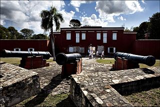
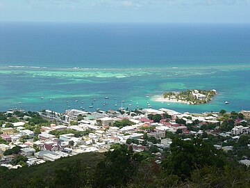
Frederiksted is both a town and one of the two administrative districts of St. Croix, U.S. Virgin Islands. It is a grid-planned city, designed by surveyor Jens Beckfor, originally to 14x14 blocks but built 7x7 to enhance the island commerce in the 1700s. Fewer than 1,000 people live in Frederiksted proper, but nearly 10,000 live on the greater western side of the island. Christiansted is about 30 years older, but commerce was limited by its natural, shallow protective reef. Frederiksted was built in the leeward side of the island for calm seas and a naturally deep port. It is home to Fort Frederik, constructed to protect the town from pirate raids and attacks from rival imperialist nations and named after Frederick V of Denmark, who purchased the Danish West Indies in 1754.

Seaborne Virgin Island Inc, operating as Seaborne Airlines, is a FAR Part 121 airline headquartered in Carolina, Puerto Rico, near the territory's capital of San Juan. It operates a seaplane shuttle service between St. Croix and St. Thomas. Originally headquartered on St. Croix in the US Virgin Islands, the company relocated to Puerto Rico in 2014.

<span class="mw-page-title-main">Christiansted National Historic Site</span> 7 acres in St. Croix, US Virgin Islands managed by the National Park Service

Christiansted National Historic Site commemorates urban colonial development of the Virgin Islands. It features 18th- and 19th-century structures in the heart of Christiansted, the capital of the former Danish West Indies on St. Croix Island.

<span class="mw-page-title-main">History of the United States Virgin Islands</span>

The United States Virgin Islands, often abbreviated USVI, are a group of islands and cays located in the Lesser Antilles of the Eastern Caribbean, consisting of three main islands and fifty smaller islets and cays. Like many of their Caribbean neighbors, the history of the islands is characterized by native Amerindian settlement, European colonization, and the Atlantic slave trade.

<span class="mw-page-title-main">Fort Frederik</span> United States historic place

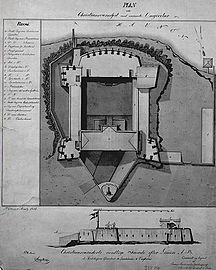
Fort Frederik, also known as Frederiksfort, is a U.S. National Historic Landmark in Frederiksted, United States Virgin Islands. It was built between 1752 and 1760 by Denmark-Norway to defend the economic interests of the natural deep water port of Frederiksted and to ward off pirates. It has red and white painted walls, making it quite different then yellow and white of Fort Christiansværn on the other side of the island. It is located at the north end of Frederiksted, in St. Croix, south of the junction of Mahogany Road and VI 631. It should not be confused with Frederiks Fort, Fortberg Hill, on St. John, which is also listed on the National Register of Historic Places.

<span class="mw-page-title-main">Reef Bay Sugar Factory Historic District</span> United States historic place

Reef Bay Sugar Factory Historic District is a historic section of Saint John, United States Virgin Islands located on the south central coast adjacent to Reef Bay. The land is the site of a sugar factory. The property was added to the U.S. National Register of Historic Places on July 23, 1981.

<span class="mw-page-title-main">Sugar production in the Danish West Indies</span> Historical sugar production in the US Virgin Islands

Sugar production in the United States Virgin Islands was an important part of the economy of the United States Virgin Islands for over two hundred years. Long before the islands became part of the United States in 1917, the islands, in particular the island of Saint Croix, was exploited by the Danish from the early 18th century and by 1800 over 30,000 acres were under cultivation, earning Saint Croix a reputation as the "Garden of the West Indies". Since the closing of the last sugar factory on Saint Croix in 1966, the industry has become only a memory.

Religion in the United States Virgin Islands is varied, though most U.S. Virgin Islanders are Christian. The U.S. Virgin Islands has a history of Judaism and Christianity, with Jews first settling on the islands in 1655. It is estimated that only 5-6% of the population is non-Christian.

<span class="mw-page-title-main">Arnold R. Highfield</span> American poet

Arnold Ray Highfield was an American professor, historian, writer, and poet, best known for his historical works on the Danish West Indies and the United States Virgin Islands.

<span class="mw-page-title-main">U.S. Virgin Islands Governor's Mansion</span>

U.S. Virgin Islands Governor's Mansion may refer to any one of the three official residences owned by the government of the U.S. Virgin Islands and provided to the Governor of the United States Virgin Islands. One residence is located on each of the three largest inhabited islands of this U.S. territory in the Caribbean. The U.S. Virgin Islands maintains more official gubernatorial residences than any other state or territory of the United States.

Slob Historic District, near Christiansted, Virgin Islands, is a historic district which was listed on the National Register of Historic Places in 1987. The listing included nine contributing buildings, three contributing structures, and a contributing site on 9 acres (3.6 ha).

<span class="mw-page-title-main">Estate Rust Op Twist</span>

Estate Rust-Op-Twist, situated near Christiansted on the island of Saint Croix in the U.S. Virgin Islands, is a former colonial sugar plantation. It was a hub of sugar production from 1755 until the early 1900s, and is currently listed on the US National Register of Historic Places.

<span class="mw-page-title-main">The Buccaneer (resort)</span>

The Buccaneer, formally known as The Buccaneer Beach & Golf Resort, is a luxury historic hotel and beach resort about 3 miles (4.8 km) northeast of Christiansted, on the island of Saint Croix, U. S. Virgin Islands, beyond Altona Lagoon. Set in 240 acres with an 18-hole golf course and three private beaches, it was opened by the Armstrong family as an inn in 1947 and was listed on the National Registry of the Historic Hotels of America in 2006.

References

Commons-logo.svg Media related to Christiansted at Wikimedia Commons