
Taxila is a significant archaeological site in the modern city of the same name in Punjab, Pakistan. It lies about 25 km (16 mi) northwest of Islamabad and Rawalpindi, and 25 km (16 mi) southwest of Haripur, Khyber Pakhtunkhwa, just off the famous Grand Trunk Road.

The Maurya Empire was a geographically extensive Iron Age historical power in South Asia based in Magadha, founded by Chandragupta Maurya in 322 BCE, and existing in loose-knit fashion until 185 BCE. The Maurya Empire was centralized by the conquest of the Indo-Gangetic Plain, and its capital city was located at Pataliputra. Outside this imperial center, the empire's geographical extent was dependent on the loyalty of military commanders who controlled the armed cities sprinkling it. During Ashoka's rule the empire briefly controlled the major urban hubs and arteries of the Indian subcontinent excepting the deep south. It declined for about 50 years after Ashoka's rule, and dissolved in 185 BCE with the assassination of Brihadratha by Pushyamitra Shunga and foundation of the Shunga dynasty in Magadha.

Rawalpindi District, is a district located in the northernmost part of the Punjab province of Pakistan. Parts of the district form part of the Islamabad Rawalpindi metropolitan area. Rawalpindi city is the district capital.

Haripur is the main city of the Haripur District in Hazara, Khyber Pukhtunkhwa in Pakistan, with Swabi and Buner to the west, some65 km (40 mi) north of Islamabad and 35 km Khanpur Road Tofkian Valley Taxila and 35 km (22 mi) south of Abbottabad. It is in a hilly plain area at an altitude of 520 m (1,706 ft).

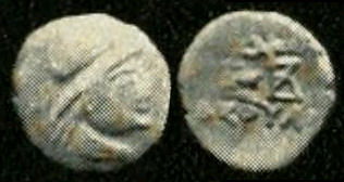
Zeionises was an Indo-Scythian satrap.

Phalia is a city and headquarters of Phalia Tehsil of Mandi Bahauddin District, Punjab, Pakistan.

Shahbaz Garhi, or Shahbazgarhi, is a village and historic site located in Mardan District of Khyber Pakhtunkhwa, Pakistan. It is at an altitude of 293 metres.

Rawalpindi is a tehsil - an administrative subdivision - of Rawalpindi District in the western part of the Punjab province, Pakistan, it contains the district capital - the city of Rawalpindi.

The history of Sindh or Sind refers to the history of the modern-day Pakistani province of Sindh, as well as neighboring regions that periodically came under its sway. Sindh has longer history of dynastic rule than any other province of Pakistan due to its relatively isolated location, as compared to Punjab and Balochistan. Sindh was a cradle of civilization as the center of the ancient Indus Valley civilization, and through its long history was the seat of several dynasties that helped shape its identity.
Chach was a Hindu Brahmin king of Sindh region of the Indian subcontinent in the mid-7th century CE. Chach expanded the kingdom of Sindh, and his successful efforts to subjugate surrounding monarchies and ethnic groups into an empire covering the entire Indus valley and beyond were recorded in the Chach Nama.

Chhachh or Chach is a region located between Peshawar and Islamabad at the northern tip of Attock, consisting of an alluvial plain extending from Attock District of Punjab, Pakistan, southwest of Topi and Swabi.
Hazro is a town located at north-west of Pakistan in Hazro Tehsil of Attock District in Punjab Privince of Pakistan.
Attock Tehsil is one of the six tehsils of Attock District in the Punjab Province of Pakistan. The Indus River bounds it on the north-west, dividing it from the Khyber Pakhtunkhwa, while the Haro River flows through from east to west.
Mong or Mung is a village and Union Council of Mandi Bahauddin District in the Punjab province of Pakistan. It is located at 32.6500°N 73.5167°E at an altitude of 217 metres. It is a historic and densely populated village.
Mahattah, or Matta, was the Rajput chief and later feudatory of Siwistan, in what is now Pakistan. He ruled from Sehwan Sharif, in the Sindh region, in the 7th century CE.

Punjabi Muslims are adherents of Islam who identify linguistically, culturally, and genealogically as Punjabis. Primarily geographically native to the Punjab province of Pakistan today, many have ancestry in the entire Punjab region, split between India and Pakistan in the contemporary era. Forming the majority of the Punjabi ethnicity in the greater Punjab region. Punjabi Muslims speak or identify the Punjabi language as a mother tongue. With a population of more than 90 million, they are the largest ethnic group in Pakistan and the world's third-largest Islam-adhering ethnicity after Arabs and Bengalis. The majority of Punjabi Muslims are adherents of Sunni Islam, while a minority adhere to Shia Islam and other sects, including the Ahmadiyya community which originated in Punjab during the British Raj.
Battle of Chach, was fought in 1008 AD between the Ghaznavid army of Sultan Mahmud bin Sebuktigin and the Hindu Shahi army of Anandapala, near Hazro, resulting in the latter's defeat. This left the north Indian region vulnerable to further invasions.
Hameed is a village in the Chach Valley of Hazro Tehsil in Attock District of Punjab Province, Pakistan.

Taxila is a city in Rawalpindi District of the Punjab, Pakistan. Taxila is located about 32 km (20 mi) north-west of Islamabad and Rawalpindi, along the historic Grand Trunk Road, near the important Sikh pilgrimage centre of Hasan Abdal, and the Mughal-era Wah Gardens.
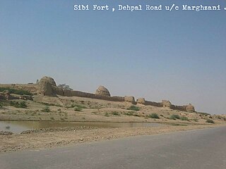
The Sibi Fort is situated in Sibi city of Balochistan Province, Pakistan. The Sibi (Siwi) was popular place of the Chachnama that the King Chach defeated Sewas, pushing them out of this place captured Sibi Fort. The Hindu rulers Sewas had kept this for some time but lost to king Chach in 550 A.D. The Brahman rule continued here till the early part of eighth century A.D. When the young Arab general [Muhammad bin Qasim] conquered the whole of these areas, In the 11th century Sibi was included in Ghaznavid Empire. The Muslims rule remained it included in the Suba Multan under Nasir ul din Kabacha


